Property Record
10777 Kuykendahl Rd, Spring, TX 77382

Property Detail
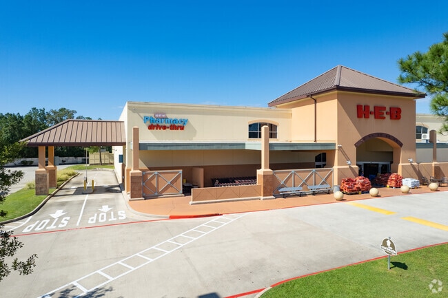
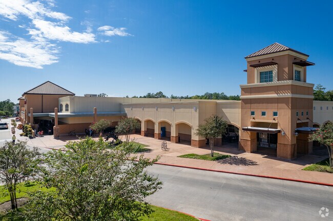
10777 Kuykendahl Rd
Houston-Pasadena-The Woodlands, TX
S827400 - REGENCY WOODLANDS KUYKENDAHL RETAIL LTD, RES A7-C, ACRES 7.2634
8274-00-00708
MONTGOMERY
Commercialnec
Texas
B and X Area of moderate flood hazard, usually the area between the limits of the 100-year and 500-year floods.
d
2024
7.26 AC
2025
Montgomery County
690603
Houston
88,739 SF
NEARBY LISTINGS FOR SALE OR LEASE
DEMOGRAPHICS near 10777 Kuykendahl Rd
1 mile
3 mile
5 mile
2025 Total Population
7,758
81,986
182,911
2030 Population
8,961
93,528
208,924
Pop Growth 2025-2030
+ 15.51%
+ 14.08%
+ 14.22%
Average Age
41
40
39
2025 Total Households
2,700
28,703
67,661
HH Growth 2025-2030
+ 16.04%
+ 14.76%
+ 14.99%
Median Household Inc
$234,924
$150,916
$123,890
Avg Household Size
2.90
2.80
2.70
2025 Avg HH Vehicles
2.00
2.00
2.00
Median Home Value
$623,846
$545,153
$467,062
Median Year Built
2003
2000
2006
Nearby Places
Map Layers
Map Styles
 Street
 Aerial
Layers
 Traffic
 Biking
Places
Listings with unknown addresses are not visible on the map
- Restaurants
- Banks
- Shops
- Fitness
- Groceries
PUBLIC TRANSPORTATION
AIRPORT
George Bush Intcntl/Houston
Drive
Walk
Distance
George Bush Intcntl/Houston
35 min
26.3 mi
Freight Ports
Port of Houston
Drive
Walk
Distance
Port of Houston
58 min
42.0 mi
Nearby Properties
Address
Land Use
TOTAL SIZE
Lot Size
Zoning
Address
Land Use
TOTAL SIZE
Lot Size
Zoning
370,296 SF
14.05 AC
Address
Land Use
TOTAL SIZE
Lot Size
Zoning
392,960 SF
20.01 AC
6
Address
Land Use
TOTAL SIZE
Lot Size
Zoning
289,737 SF
13.83 AC
Address
Land Use
TOTAL SIZE
Lot Size
Zoning
295,608 SF
10.07 AC
6
Address
Land Use
TOTAL SIZE
Lot Size
Zoning
289,611 SF
13.57 AC
Address
Land Use
TOTAL SIZE
Lot Size
Zoning
299,416 SF
50 AC
6
Address
Land Use
TOTAL SIZE
Lot Size
Zoning
297,153 SF
17.13 AC
6
Address
Land Use
TOTAL SIZE
Lot Size
Zoning
163,392 SF
4.53 AC
Address
Land Use
TOTAL SIZE
Lot Size
Zoning
87,445 SF
6.45 AC
Address
Land Use
TOTAL SIZE
Lot Size
Zoning
153,063 SF
17.50 AC
Address
Land Use
TOTAL SIZE
Lot Size
Zoning
385,000 SF
68.27 AC
6
Address
Land Use
TOTAL SIZE
Lot Size
Zoning
139,140 SF
18.22 AC
6
Address
Land Use
TOTAL SIZE
Lot Size
Zoning
138,468 SF
16.33 AC
6
Address
Land Use
TOTAL SIZE
Lot Size
Zoning
123,497 SF
18.77 AC
Address
Land Use
TOTAL SIZE
Lot Size
Zoning
76,841 SF
12.17 AC
Address
Land Use
TOTAL SIZE
Lot Size
Zoning
13.76 AC
Address
Land Use
TOTAL SIZE
Lot Size
Zoning
100,374 SF
11.24 AC
Address
Land Use
TOTAL SIZE
Lot Size
Zoning
61,218 SF
9.30 AC
Address
Land Use
TOTAL SIZE
Lot Size
Zoning
106,015 SF
11.86 AC
6
Address
Land Use
TOTAL SIZE
Lot Size
Zoning
172,784 SF
20.60 AC
2
Address
Land Use
TOTAL SIZE
Lot Size
Zoning
278,939 SF
13.76 AC
Address
Land Use
TOTAL SIZE
Lot Size
Zoning
5,044 SF
42.52 AC
6
Address
Land Use
TOTAL SIZE
Lot Size
Zoning
190,000 SF
24.21 AC
Address
Land Use
TOTAL SIZE
Lot Size
Zoning
108,824 SF
12.44 AC
Address
Land Use
TOTAL SIZE
Lot Size
Zoning
82,051 SF
10.14 AC
6
Address
Land Use
TOTAL SIZE
Lot Size
Zoning
165,218 SF
17.40 AC
2
Address
Land Use
TOTAL SIZE
Lot Size
Zoning
51,134 SF
25 AC
2
Address
Land Use
TOTAL SIZE
Lot Size
Zoning
94,128 SF
51.19 AC
2
Address
Land Use
TOTAL SIZE
Lot Size
Zoning
151,978 SF
21.94 AC
Address
Land Use
TOTAL SIZE
Lot Size
Zoning
48,525 SF
4.68 AC
The World's #1 Commercial Real Estate Marketplace
Connect with us
© 2026 CoStar Group
The information above has been obtained from sources believed reliable. While we do not doubt its accuracy we have not verified it and make no guarantee, warranty or representation about it. It is your responsibility to independently confirm its accuracy and completeness. Any projections, opinions, assumptions, or estimates used are for example only and do not represent the current or future performance of the property. The value of this transaction to you depends on tax and other factors which should be evaluated by your tax, financial, and legal advisors. You and your advisors should conduct a careful, independent investigation of the property to determine to your satisfaction the suitability of the property for your needs.