Property Record
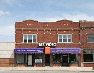
10820 W Warren Ave, Dearborn, MI 48126

Property Detail
10820 W Warren Ave
32-10-054-32-014
LOT 3 & 4 THEISENS AVIATION FIELD SUB
Storebuilding
WAYNE
BB
Michigan
B and X Area of moderate flood hazard, usually the area between the limits of the 100-year and 500-year floods.
3-4
2025
0.09 AC
2025
Detroit E of Woodward
573600
Detroit
4,448 SF
Detroit-Warren-Dearborn, MI
NEARBY LISTINGS FOR SALE OR LEASE
DEMOGRAPHICS near 10820 W Warren Ave
1 mile
3 mile
5 mile
2025 Total Population
9,824
108,716
313,965
2030 Population
10,423
113,351
319,310
Pop Growth 2025-2030
+ 6.10%
+ 4.26%
+ 1.70%
Average Age
40
40
38
2025 Total Households
3,978
44,134
125,888
HH Growth 2025-2030
+ 6.21%
+ 4.02%
+ 1.65%
Median Household Inc
$26,144
$37,922
$43,306
Avg Household Size
2.30
2.30
2.40
2025 Avg HH Vehicles
1.00
1.00
1.00
Median Home Value
$74,064
$86,502
$109,107
Median Year Built
1948
1948
1950
Nearby Places
Map Layers
Map Styles
 Street
 Aerial
Layers
 Traffic
 Biking
Places
Listings with unknown addresses are not visible on the map
- Restaurants
- Banks
- Shops
- Fitness
- Groceries
PUBLIC TRANSPORTATION
COMMUTER RAIL
Drive
Walk
Distance
12 min
5.4 mi
Drive
Walk
Distance
13 min
6.3 mi
AIRPORT
Windsor International
Drive
Walk
Distance
Windsor International
29 min
16.2 mi
Detroit Metro Wayne County
Drive
Walk
Distance
Detroit Metro Wayne County
28 min
17.8 mi
Nearby Properties
Address
Land Use
TOTAL SIZE
Lot Size
Zoning
Address
Land Use
TOTAL SIZE
Lot Size
Zoning
830,075 SF
167.21 AC
BC
Address
Land Use
TOTAL SIZE
Lot Size
Zoning
475,972 SF
42.17 AC
RD
Address
Land Use
TOTAL SIZE
Lot Size
Zoning
1,043,110 SF
35.36 AC
RE
Address
Land Use
TOTAL SIZE
Lot Size
Zoning
153,040 SF
2.13 AC
BC
Address
Land Use
TOTAL SIZE
Lot Size
Zoning
783,976 SF
52.57 AC
M4
Address
Land Use
TOTAL SIZE
Lot Size
Zoning
429,654 SF
49.81 AC
TR
Address
Land Use
TOTAL SIZE
Lot Size
Zoning
551,788 SF
31.52 AC
BC
Address
Land Use
TOTAL SIZE
Lot Size
Zoning
80,861 SF
1.17 AC
BC
Address
Land Use
TOTAL SIZE
Lot Size
Zoning
111,008 SF
26.62 AC
IB
Address
Land Use
TOTAL SIZE
Lot Size
Zoning
365,040 SF
382 AC
M4
Address
Land Use
TOTAL SIZE
Lot Size
Zoning
520,522 SF
51.78 AC
M4
Address
Land Use
TOTAL SIZE
Lot Size
Zoning
192,813 SF
28.92 AC
TR
Address
Land Use
TOTAL SIZE
Lot Size
Zoning
590,652 SF
21.79 AC
TM
Address
Land Use
TOTAL SIZE
Lot Size
Zoning
145,702 SF
16.35 AC
TR
Address
Land Use
TOTAL SIZE
Lot Size
Zoning
303,705 SF
17.28 AC
ID
Address
Land Use
TOTAL SIZE
Lot Size
Zoning
72,326 SF
0.74 AC
BB
Address
Land Use
TOTAL SIZE
Lot Size
Zoning
331,121 SF
21.01 AC
BC
Address
Land Use
TOTAL SIZE
Lot Size
Zoning
102,920 SF
10.72 AC
BB
Address
Land Use
TOTAL SIZE
Lot Size
Zoning
153,668 SF
9.16 AC
RD
Address
Land Use
TOTAL SIZE
Lot Size
Zoning
57,139 SF
35 AC
BC
Address
Land Use
TOTAL SIZE
Lot Size
Zoning
95,908 SF
1.12 AC
BB
Address
Land Use
TOTAL SIZE
Lot Size
Zoning
207,081 SF
8.80 AC
B5
Address
Land Use
TOTAL SIZE
Lot Size
Zoning
189,338 SF
18.10 AC
BB
Address
Land Use
TOTAL SIZE
Lot Size
Zoning
115,159 SF
10.49 AC
BB
Address
Land Use
TOTAL SIZE
Lot Size
Zoning
80,871 SF
4.98 AC
BB
Address
Land Use
TOTAL SIZE
Lot Size
Zoning
83,552 SF
20.32 AC
IC
Address
Land Use
TOTAL SIZE
Lot Size
Zoning
82,196 SF
3.49 AC
BB
Address
Land Use
TOTAL SIZE
Lot Size
Zoning
864,446 SF
17.98 AC
IB
Address
Land Use
TOTAL SIZE
Lot Size
Zoning
95,549 SF
6.46 AC
RE
Address
Land Use
TOTAL SIZE
Lot Size
Zoning
147,942 SF
14 AC
IA
The World's #1 Commercial Real Estate Marketplace
Connect with us
© 2026 CoStar Group
The information above has been obtained from sources believed reliable. While we do not doubt its accuracy we have not verified it and make no guarantee, warranty or representation about it. It is your responsibility to independently confirm its accuracy and completeness. Any projections, opinions, assumptions, or estimates used are for example only and do not represent the current or future performance of the property. The value of this transaction to you depends on tax and other factors which should be evaluated by your tax, financial, and legal advisors. You and your advisors should conduct a careful, independent investigation of the property to determine to your satisfaction the suitability of the property for your needs.