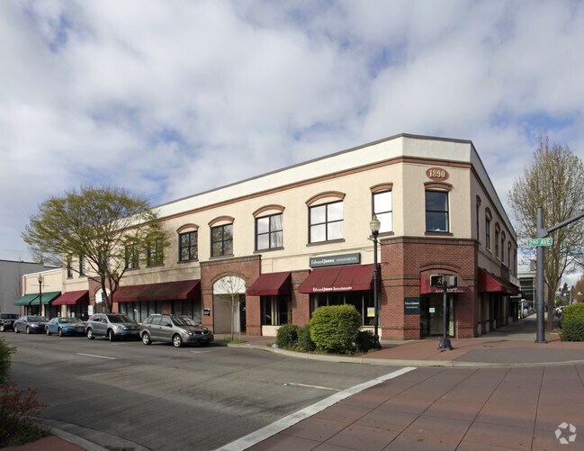
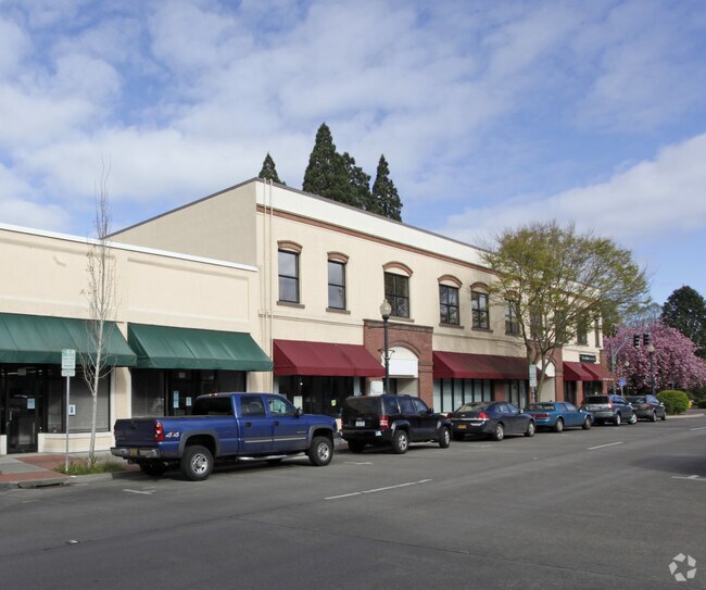
Property Record
109 Se 2Nd Ave, Hillsboro, OR 97123

Property Detail
109 Se 2Nd Ave
R0702323
HILLSBORO, BLOCK 7, LOT PT 4
Commercialbuilding
Washington
SCC-DT
Oregon
B and X Area of moderate flood hazard, usually the area between the limits of the 100-year and 500-year floods.
4
2024
0.30 AC
2026
Sunset Corridor/Hillsboro
032604
Portland
37,740 SF
Portland-Vancouver-Hillsboro, OR-WA
NEARBY LISTINGS FOR SALE OR LEASE
DEMOGRAPHICS near 109 Se 2Nd Ave
1 mile
3 mile
5 mile
2025 Total Population
14,305
64,245
130,037
2030 Population
14,492
65,130
132,163
Pop Growth 2025-2030
+ 1.31%
+ 1.38%
+ 1.63%
Average Age
39
39
39
2025 Total Households
4,792
21,420
46,335
HH Growth 2025-2030
+ 1.29%
+ 1.43%
+ 1.73%
Median Household Inc
$98,086
$103,761
$104,282
Avg Household Size
2.70
2.90
2.70
2025 Avg HH Vehicles
2.00
2.00
2.00
Median Home Value
$477,592
$502,304
$515,841
Median Year Built
1973
1986
1994
Nearby Places
Map Layers
Map Styles
 Street
 Aerial
Transit
 Traffic
 Biking
Places
Listings with unknown addresses are not visible on the map
- Restaurants
- Banks
- Shops
- Fitness
- Groceries
PUBLIC TRANSPORTATION
TRANSIT/SUBWAY
Hillsboro Central/Se 3Rd Transit Center (MAX Blue Line - Tri-County Metropolitan Transportation District of Oregon Rail (TriMet Rail))
Drive
Walk
Distance
Hillsboro Central/Se 3Rd Transit Center (MAX Blue Line - Tri-County Metropolitan Transportation District of Oregon Rail (TriMet Rail))
1 min
3 min
0.2 mi
Hatfield Government Center (MAX Blue Line - Tri-County Metropolitan Transportation District of Oregon Rail (TriMet Rail))
Drive
Walk
Distance
Hatfield Government Center (MAX Blue Line - Tri-County Metropolitan Transportation District of Oregon Rail (TriMet Rail))
1 min
4 min
0.2 mi
Hillsboro Health District Max Station (MAX Blue Line - TriMet)
Drive
Walk
Distance
Hillsboro Health District Max Station (MAX Blue Line - TriMet)
3 min
9 min
0.5 mi
Washington/Se 12Th Avenue (MAX Blue Line - Tri-County Metropolitan Transportation District of Oregon Rail (TriMet Rail))
Drive
Walk
Distance
Washington/Se 12Th Avenue (MAX Blue Line - Tri-County Metropolitan Transportation District of Oregon Rail (TriMet Rail))
4 min
18 min
1.0 mi
AIRPORT
Portland International
Drive
Walk
Distance
Portland International
50 min
29.9 mi
Freight Ports
Port of Portland
Drive
Walk
Distance
Port of Portland
33 min
19.0 mi
SALE & LEASE HISTORY
LISTING DATE
SALE/LEASE

Nov 16, 2017
For Sale
Nearby Properties
Address
Land Use
TOTAL SIZE
Lot Size
Zoning
Address
Land Use
TOTAL SIZE
Lot Size
Zoning
1,619,885 SF
115.71 AC
I-P
Address
Land Use
TOTAL SIZE
Lot Size
Zoning
9.97 AC
SCC-DT
Address
Land Use
TOTAL SIZE
Lot Size
Zoning
60.97 AC
INST
Address
Land Use
TOTAL SIZE
Lot Size
Zoning
5.83 AC
INST
Address
Land Use
TOTAL SIZE
Lot Size
Zoning
248,332 SF
4.26 AC
SCC-DT
Address
Land Use
TOTAL SIZE
Lot Size
Zoning
20.33 AC
I-S
Address
Land Use
TOTAL SIZE
Lot Size
Zoning
53.49 AC
SCFI
Address
Land Use
TOTAL SIZE
Lot Size
Zoning
256,652 SF
48.72 AC
SFR-7
Address
Land Use
TOTAL SIZE
Lot Size
Zoning
13,368 SF
112.70 AC
I-G
Address
Land Use
TOTAL SIZE
Lot Size
Zoning
82,297 SF
175.24 AC
I-G
Address
Land Use
TOTAL SIZE
Lot Size
Zoning
0.06 AC
I-P
Address
Land Use
TOTAL SIZE
Lot Size
Zoning
252,251 SF
2.62 AC
SCC-DT
Address
Land Use
TOTAL SIZE
Lot Size
Zoning
3,616 SF
0.85 AC
SCC-DT
Address
Land Use
TOTAL SIZE
Lot Size
Zoning
6.03 AC
SCR-MD
Address
Land Use
TOTAL SIZE
Lot Size
Zoning
24.26 AC
I-P
Address
Land Use
TOTAL SIZE
Lot Size
Zoning
43,041 SF
9.43 AC
SFR-7
Address
Land Use
TOTAL SIZE
Lot Size
Zoning
240,000 SF
39.66 AC
SFR-7
Address
Land Use
TOTAL SIZE
Lot Size
Zoning
354,705 SF
18.29 AC
C-G
Address
Land Use
TOTAL SIZE
Lot Size
Zoning
147 SF
14.87 AC
I-S
Address
Land Use
TOTAL SIZE
Lot Size
Zoning
205,467 SF
19.44 AC
C-G
Address
Land Use
TOTAL SIZE
Lot Size
Zoning
17.84 AC
SC-BP
Address
Land Use
TOTAL SIZE
Lot Size
Zoning
180,900 SF
6.33 AC
SCR-HD
Address
Land Use
TOTAL SIZE
Lot Size
Zoning
347,362 SF
14.06 AC
C-G
Address
Land Use
TOTAL SIZE
Lot Size
Zoning
285,970 SF
1.58 AC
SCC-DT
Address
Land Use
TOTAL SIZE
Lot Size
Zoning
24.94 AC
SFR-7
Address
Land Use
TOTAL SIZE
Lot Size
Zoning
1.22 AC
I-G
Address
Land Use
TOTAL SIZE
Lot Size
Zoning
83,200 SF
17.96 AC
SFR-7
Address
Land Use
TOTAL SIZE
Lot Size
Zoning
9.47 AC
SFR-7
Address
Land Use
TOTAL SIZE
Lot Size
Zoning
11,904 SF
128.70 AC
The World's #1 Commercial Real Estate Marketplace
Connect with us
© 2026 CoStar Group
The information above has been obtained from sources believed reliable. While we do not doubt its accuracy we have not verified it and make no guarantee, warranty or representation about it. It is your responsibility to independently confirm its accuracy and completeness. Any projections, opinions, assumptions, or estimates used are for example only and do not represent the current or future performance of the property. The value of this transaction to you depends on tax and other factors which should be evaluated by your tax, financial, and legal advisors. You and your advisors should conduct a careful, independent investigation of the property to determine to your satisfaction the suitability of the property for your needs.