Property Record
109 Spinner Dr, Broussard, LA 70518
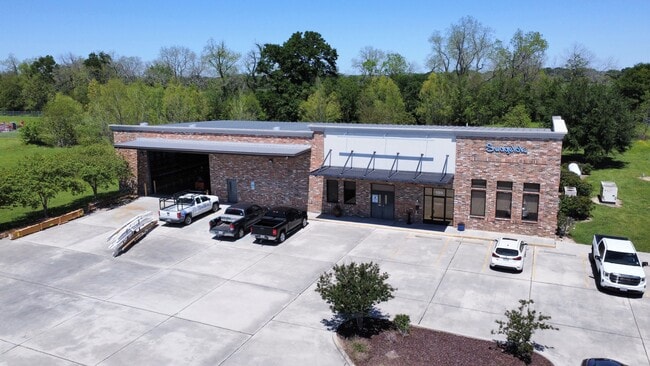


Property Detail
109 Spinner Dr
Lafayette, LA
LOT F SUGAR CREST INDUSTRIAL PARK PH III (2.421 AC)
6131956
LAFAYETTE
Warehouse
Louisiana
B and X Area of moderate flood hazard, usually the area between the limits of the 100-year and 500-year floods.
f
2024
2.42 AC
2024
Outlying Lafayette Parish
001425
Lafayette
7,800 SF
NEARBY LISTINGS FOR SALE OR LEASE
DEMOGRAPHICS near 109 Spinner Dr
1 mile
3 mile
5 mile
2025 Total Population
1,588
13,773
45,776
2030 Population
1,681
14,395
47,666
Pop Growth 2025-2030
+ 5.86%
+ 4.52%
+ 4.13%
Average Age
40
39
38
2025 Total Households
698
5,451
17,766
HH Growth 2025-2030
+ 5.87%
+ 4.64%
+ 4.26%
Median Household Inc
$65,913
$70,735
$76,589
Avg Household Size
2.30
2.50
2.50
2025 Avg HH Vehicles
2.00
2.00
2.00
Median Home Value
$285,980
$269,402
$276,089
Median Year Built
2008
2000
2000
Nearby Places
Map Layers
Map Styles
 Street
 Aerial
Transit
 Traffic
 Biking
Places
Listings with unknown addresses are not visible on the map
- Restaurants
- Banks
- Shops
- Fitness
- Groceries
PUBLIC TRANSPORTATION
COMMUTER RAIL
Lafayette Amtrak Station (Sunset Limited - Amtrak)
Drive
Walk
Distance
Lafayette Amtrak Station (Sunset Limited - Amtrak)
13 min
8.1 mi
AIRPORT
Lafayette Regional/Paul Fournet Field
Drive
Walk
Distance
Lafayette Regional/Paul Fournet Field
12 min
7.1 mi
Freight Ports
Port of Iberia
Drive
Walk
Distance
Port of Iberia
25 min
17.3 mi
SALE & LEASE HISTORY
LISTING DATE
SALE/LEASE

Apr 04, 2024
For Sale
Nearby Properties
Address
Land Use
TOTAL SIZE
Lot Size
Zoning
Address
Land Use
TOTAL SIZE
Lot Size
Zoning
13.87 AC
Address
Land Use
TOTAL SIZE
Lot Size
Zoning
200,194 SF
30.80 AC
Address
Land Use
TOTAL SIZE
Lot Size
Zoning
9.02 AC
Address
Land Use
TOTAL SIZE
Lot Size
Zoning
5,625 SF
25.86 AC
Address
Land Use
TOTAL SIZE
Lot Size
Zoning
25,886 SF
8.39 AC
Address
Land Use
TOTAL SIZE
Lot Size
Zoning
22,489 SF
6.52 AC
Address
Land Use
TOTAL SIZE
Lot Size
Zoning
1.87 AC
Address
Land Use
TOTAL SIZE
Lot Size
Zoning
283,435 SF
39.25 AC
Address
Land Use
TOTAL SIZE
Lot Size
Zoning
4,800 SF
17.84 AC
Address
Land Use
TOTAL SIZE
Lot Size
Zoning
106,776 SF
17.43 AC
Address
Land Use
TOTAL SIZE
Lot Size
Zoning
84,500 SF
15 AC
Address
Land Use
TOTAL SIZE
Lot Size
Zoning
63,154 SF
6.20 AC
Address
Land Use
TOTAL SIZE
Lot Size
Zoning
Address
Land Use
TOTAL SIZE
Lot Size
Zoning
81,000 SF
20.01 AC
Address
Land Use
TOTAL SIZE
Lot Size
Zoning
23,450 SF
9.30 AC
Address
Land Use
TOTAL SIZE
Lot Size
Zoning
14.66 AC
Address
Land Use
TOTAL SIZE
Lot Size
Zoning
52,080 SF
1.78 AC
Address
Land Use
TOTAL SIZE
Lot Size
Zoning
18,592 SF
12.53 AC
Address
Land Use
TOTAL SIZE
Lot Size
Zoning
6.64 AC
Address
Land Use
TOTAL SIZE
Lot Size
Zoning
75,393 SF
20.03 AC
Address
Land Use
TOTAL SIZE
Lot Size
Zoning
55,500 SF
10 AC
Address
Land Use
TOTAL SIZE
Lot Size
Zoning
Address
Land Use
TOTAL SIZE
Lot Size
Zoning
57,585 SF
10.39 AC
Address
Land Use
TOTAL SIZE
Lot Size
Zoning
40,703 SF
4.31 AC
Address
Land Use
TOTAL SIZE
Lot Size
Zoning
49,945 SF
2.29 AC
Address
Land Use
TOTAL SIZE
Lot Size
Zoning
33,978 SF
1.21 AC
Address
Land Use
TOTAL SIZE
Lot Size
Zoning
21,293 SF
2.26 AC
Address
Land Use
TOTAL SIZE
Lot Size
Zoning
1.60 AC
The World's #1 Commercial Real Estate Marketplace
Connect with us
© 2026 CoStar Group
The information above has been obtained from sources believed reliable. While we do not doubt its accuracy we have not verified it and make no guarantee, warranty or representation about it. It is your responsibility to independently confirm its accuracy and completeness. Any projections, opinions, assumptions, or estimates used are for example only and do not represent the current or future performance of the property. The value of this transaction to you depends on tax and other factors which should be evaluated by your tax, financial, and legal advisors. You and your advisors should conduct a careful, independent investigation of the property to determine to your satisfaction the suitability of the property for your needs.