Property Record
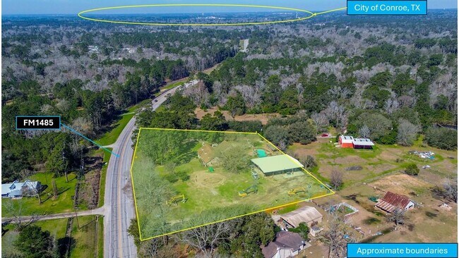
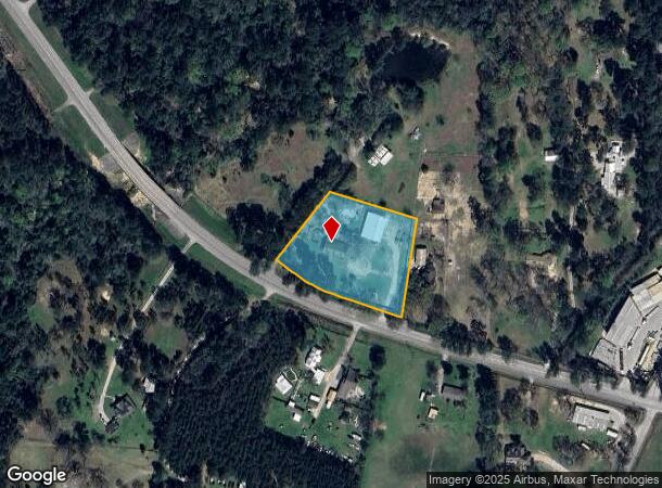
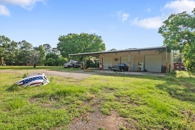
10919 Fm 1485 Rd, Conroe, TX 77306
NEARBY LISTINGS FOR SALE OR LEASE
Property Detail
10919 Fm 1485 Rd
Houston-Pasadena-The Woodlands, TX
Davis John A
0188-00-02001
Montgomery
Sfr
Texas
X
1.41 AC
48339C0425G
The Woodlands/Conroe
4,894 SF
Houston
DEMOGRAPHICS near 10919 Fm 1485 Rd
1 Mile
3 Mile
5 Mile
2024 Total Population
984
13,652
44,869
2029 Population
1,186
16,998
55,357
Pop Growth 2024-2029
+ 20.53%
+ 24.51%
+ 23.37%
Average Age
37
34
36
2024 Total Households
328
4,175
13,885
HH Growth 2024-2029
+ 20.43%
+ 24.50%
+ 23.85%
Median Household Inc
$54,333
$60,396
$59,145
Avg Household Size
2.90
3.10
3.10
2024 Avg HH Vehicles
3.00
3.00
2.00
Median Home Value
$160,714
$170,132
$173,188
Median Year Built
1992
2005
2005
Nearby Places
Map Layers
Map Styles
 Street
 Aerial
- Restaurants
- Banks
- Shops
- Fitness
- Groceries
PUBLIC TRANSPORTATION
AIRPORT
George Bush Intcntl/Houston
DRIVE
WALK
Distance
George Bush Intcntl/Houston
48 min
33.5 mi
Freight Ports
Port of Houston
DRIVE
WALK
Distance
Port of Houston
69 min
48.8 mi
SALE & LEASE HISTORY
LISTING DATE
SALE/LEASE

Mar 04, 2025
For Sale
Jun 18, 2025
For Lease
Nearby Properties
Address
Land Use
TOTAL SIZE
Lot Size
Zoning
Address
Land Use
TOTAL SIZE
Lot Size
Zoning
266,751 SF
12.95 AC
1
Address
Land Use
TOTAL SIZE
Lot Size
Zoning
124,209 SF
9.18 AC
1
Address
Land Use
TOTAL SIZE
Lot Size
Zoning
187,426 SF
61.77 AC
1
Address
Land Use
TOTAL SIZE
Lot Size
Zoning
140,900 SF
83.24 AC
1
Address
Land Use
TOTAL SIZE
Lot Size
Zoning
84,192 SF
23.22 AC
1
Address
Land Use
TOTAL SIZE
Lot Size
Zoning
44,182 SF
6.25 AC
1
Address
Land Use
TOTAL SIZE
Lot Size
Zoning
65,448 SF
10 AC
1
Address
Land Use
TOTAL SIZE
Lot Size
Zoning
Address
Land Use
TOTAL SIZE
Lot Size
Zoning
163,880 SF
11 AC
Address
Land Use
TOTAL SIZE
Lot Size
Zoning
61,000 SF
16.10 AC
1
Address
Land Use
TOTAL SIZE
Lot Size
Zoning
80,948 SF
15 AC
Address
Land Use
TOTAL SIZE
Lot Size
Zoning
23,912 SF
53.69 AC
1
Address
Land Use
TOTAL SIZE
Lot Size
Zoning
75,058 SF
12.66 AC
Address
Land Use
TOTAL SIZE
Lot Size
Zoning
70,794 SF
25.34 AC
1
Address
Land Use
TOTAL SIZE
Lot Size
Zoning
38,020 SF
28.47 AC
1
Address
Land Use
TOTAL SIZE
Lot Size
Zoning
11,929 SF
35.97 AC
1
Address
Land Use
TOTAL SIZE
Lot Size
Zoning
37,300 SF
11.70 AC
1
Address
Land Use
TOTAL SIZE
Lot Size
Zoning
64,868 SF
10.99 AC
1
Address
Land Use
TOTAL SIZE
Lot Size
Zoning
9,582 SF
10.46 AC
1
Address
Land Use
TOTAL SIZE
Lot Size
Zoning
77,512 SF
5.03 AC
Address
Land Use
TOTAL SIZE
Lot Size
Zoning
8,450 SF
2.16 AC
Address
Land Use
TOTAL SIZE
Lot Size
Zoning
41,456 SF
5.99 AC
1
Address
Land Use
TOTAL SIZE
Lot Size
Zoning
9,373 SF
0.93 AC
Address
Land Use
TOTAL SIZE
Lot Size
Zoning
12,866 SF
10.30 AC
1
Address
Land Use
TOTAL SIZE
Lot Size
Zoning
33,400 SF
7.05 AC
Address
Land Use
TOTAL SIZE
Lot Size
Zoning
11,543 SF
17.92 AC
1
Address
Land Use
TOTAL SIZE
Lot Size
Zoning
43,371 SF
5.04 AC
Address
Land Use
TOTAL SIZE
Lot Size
Zoning
13,960 SF
5 AC
Address
Land Use
TOTAL SIZE
Lot Size
Zoning
21,056 SF
3.62 AC
1
Address
Land Use
TOTAL SIZE
Lot Size
Zoning
8,356 SF
1.75 AC
The World's #1 Commercial Real Estate Marketplace
Connect with us
© 2026 CoStar Group
The information above has been obtained from sources believed reliable. While we do not doubt its accuracy we have not verified it and make no guarantee, warranty or representation about it. It is your responsibility to independently confirm its accuracy and completeness. Any projections, opinions, assumptions, or estimates used are for example only and do not represent the current or future performance of the property. The value of this transaction to you depends on tax and other factors which should be evaluated by your tax, financial, and legal advisors. You and your advisors should conduct a careful, independent investigation of the property to determine to your satisfaction the suitability of the property for your needs.