Property Record
1092 By Pass Rd, Vinton, VA 24179
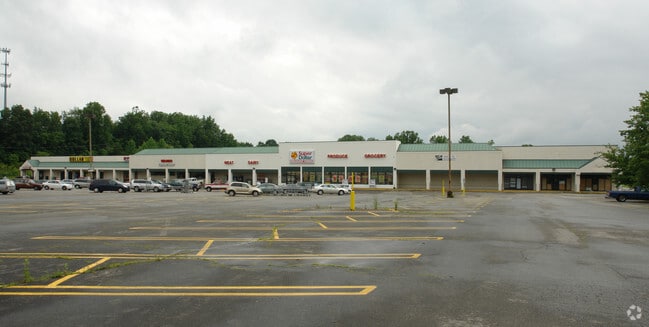

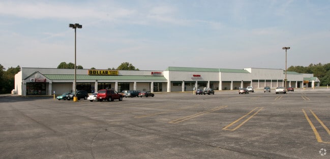
This Property Is For Sale
Property Detail
1092 By Pass Rd
061.13-04-13.02-0000
PAR A SUBD FOR P N C
Stripcommercialcenter
Roanoke
GB
Virginia
B and X Area of moderate flood hazard, usually the area between the limits of the 100-year and 500-year floods.
14.88 AC
2025
Southeast Roanoke
2025
Roanoke
031101
Roanoke, VA
58,190 SF
NEARBY LISTINGS FOR SALE OR LEASE
DEMOGRAPHICS near 1092 By Pass Rd
1 mile
3 mile
5 mile
2025 Total Population
7,855
35,726
91,632
2030 Population
7,923
36,022
91,744
Pop Growth 2025-2030
+ 0.87%
+ 0.83%
+ 0.12%
Average Age
41
40
41
2025 Total Households
3,422
15,007
39,855
HH Growth 2025-2030
+ 0.82%
+ 0.81%
+ 0.08%
Median Household Inc
$61,461
$57,092
$57,241
Avg Household Size
2.20
2.30
2.20
2025 Avg HH Vehicles
2.00
2.00
2.00
Median Home Value
$202,317
$202,193
$228,486
Median Year Built
1970
1970
1965
Nearby Places
Map Layers
Map Styles
 Street
 Aerial
Layers
 Traffic
 Biking
Places
Listings with unknown addresses are not visible on the map
- Restaurants
- Banks
- Shops
- Fitness
- Groceries
PUBLIC TRANSPORTATION
COMMUTER RAIL
Roanoke (Northeast Regional - Amtrak)
Drive
Walk
Distance
Roanoke (Northeast Regional - Amtrak)
9 min
4.2 mi
AIRPORT
Roanoke/Blacksburg Regional (Woodrum Field)
Drive
Walk
Distance
Roanoke/Blacksburg Regional (Woodrum Field)
17 min
8.0 mi
Freight Ports
Virginia Port Authority - Richmond
Drive
Walk
Distance
Virginia Port Authority - Richmond
217 min
161.2 mi
Nearby Properties
Address
Land Use
TOTAL SIZE
Lot Size
Zoning
Address
Land Use
TOTAL SIZE
Lot Size
Zoning
370 SF
105.25 AC
I-2
Address
Land Use
TOTAL SIZE
Lot Size
Zoning
214,543 SF
38.29 AC
R1S
Address
Land Use
TOTAL SIZE
Lot Size
Zoning
96,620 SF
26.84 AC
D
Address
Land Use
TOTAL SIZE
Lot Size
Zoning
87,406 SF
1.15 AC
D
Address
Land Use
TOTAL SIZE
Lot Size
Zoning
4,901 SF
17.41 AC
MXPUD
Address
Land Use
TOTAL SIZE
Lot Size
Zoning
71,696 SF
71.64 AC
INPUD/ROS
Address
Land Use
TOTAL SIZE
Lot Size
Zoning
Address
Land Use
TOTAL SIZE
Lot Size
Zoning
160,537 SF
11.08 AC
I-1
Address
Land Use
TOTAL SIZE
Lot Size
Zoning
402,320 SF
42.13 AC
I1C
Address
Land Use
TOTAL SIZE
Lot Size
Zoning
387,684 SF
27.44 AC
I-1
Address
Land Use
TOTAL SIZE
Lot Size
Zoning
142,048 SF
21.38 AC
I-1
Address
Land Use
TOTAL SIZE
Lot Size
Zoning
2,193 SF
2,914.16 AC
AG3
Address
Land Use
TOTAL SIZE
Lot Size
Zoning
29.63 AC
I-1
Address
Land Use
TOTAL SIZE
Lot Size
Zoning
19,594 SF
11.15 AC
RMF
Address
Land Use
TOTAL SIZE
Lot Size
Zoning
10,704 SF
12.76 AC
D
Address
Land Use
TOTAL SIZE
Lot Size
Zoning
11,694 SF
12.05 AC
RMF
Address
Land Use
TOTAL SIZE
Lot Size
Zoning
1,109 SF
13.44 AC
INPUD
Address
Land Use
TOTAL SIZE
Lot Size
Zoning
446,526 SF
28.10 AC
I-1
Address
Land Use
TOTAL SIZE
Lot Size
Zoning
275,300 SF
25.30 AC
PTD
Address
Land Use
TOTAL SIZE
Lot Size
Zoning
87,057 SF
12.79 AC
GB
Address
Land Use
TOTAL SIZE
Lot Size
Zoning
14,418 SF
6.47 AC
RMF
Address
Land Use
TOTAL SIZE
Lot Size
Zoning
333,572 SF
20 AC
I-1
Address
Land Use
TOTAL SIZE
Lot Size
Zoning
24,909 SF
6.36 AC
D
Address
Land Use
TOTAL SIZE
Lot Size
Zoning
95,819 SF
3.09 AC
IN
Address
Land Use
TOTAL SIZE
Lot Size
Zoning
0.78 AC
D
Address
Land Use
TOTAL SIZE
Lot Size
Zoning
39,354 SF
7.37 AC
RMF
Address
Land Use
TOTAL SIZE
Lot Size
Zoning
48.26 AC
I-1
Address
Land Use
TOTAL SIZE
Lot Size
Zoning
182,070 SF
7.38 AC
CLS
Address
Land Use
TOTAL SIZE
Lot Size
Zoning
196,215 SF
1.75 AC
D
Address
Land Use
TOTAL SIZE
Lot Size
Zoning
63,648 SF
11.51 AC
INPUD
The World's #1 Commercial Real Estate Marketplace
Connect with us
© 2026 CoStar Group
The information above has been obtained from sources believed reliable. While we do not doubt its accuracy we have not verified it and make no guarantee, warranty or representation about it. It is your responsibility to independently confirm its accuracy and completeness. Any projections, opinions, assumptions, or estimates used are for example only and do not represent the current or future performance of the property. The value of this transaction to you depends on tax and other factors which should be evaluated by your tax, financial, and legal advisors. You and your advisors should conduct a careful, independent investigation of the property to determine to your satisfaction the suitability of the property for your needs.