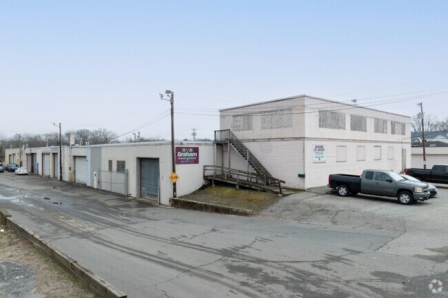
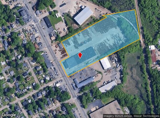
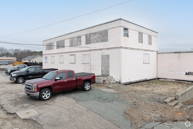
Property Record
1093 N Montello St, Brockton, MA 02301

NEARBY LISTINGS FOR SALE OR LEASE
Property Detail
1093 N Montello St
Truckterminal
Plymouth
A
Massachusetts
25021C0382F
7.71 AC
2025
Route 24
2025
Boston
510501
Boston-Cambridge-Newton, MA-NH
38,934 SF
BROC-000101-000016
DEMOGRAPHICS near 1093 N Montello St
1 Mile
3 Mile
5 Mile
2024 Total Population
10,938
89,398
197,015
2029 Population
10,800
88,364
195,191
Pop Growth 2024-2029
(1.26%)
(1.16%)
(0.93%)
Average Age
39
39
40
2024 Total Households
3,750
31,002
68,966
HH Growth 2024-2029
(1.44%)
(1.24%)
(0.98%)
Median Household Inc
$78,683
$73,657
$86,034
Avg Household Size
2.80
2.70
2.70
2024 Avg HH Vehicles
2.00
2.00
2.00
Median Home Value
$375,376
$369,223
$408,979
Median Year Built
1953
1957
1961
Nearby Places
Map Layers
Map Styles
 Street
 Aerial
- Restaurants
- Banks
- Shops
- Fitness
- Groceries
PUBLIC TRANSPORTATION
COMMUTER RAIL
Montello (Middleborough/Lakeville Line - Massachusetts Bay Transportation Authority Commuter Rail (Purple Line))
DRIVE
WALK
Distance
Montello (Middleborough/Lakeville Line - Massachusetts Bay Transportation Authority Commuter Rail (Purple Line))
3 min
14 min
0.7 mi
Brockton (Middleborough/Lakeville Line - Massachusetts Bay Transportation Authority Commuter Rail (Purple Line))
DRIVE
WALK
Distance
Brockton (Middleborough/Lakeville Line - Massachusetts Bay Transportation Authority Commuter Rail (Purple Line))
4 min
2.2 mi
AIRPORT
General Edward Lawrence Logan International
DRIVE
WALK
Distance
General Edward Lawrence Logan International
36 min
21.6 mi
Rhode Island Tf Green International
DRIVE
WALK
Distance
Rhode Island Tf Green International
69 min
44.3 mi
Nearby Properties
Address
Land Use
TOTAL SIZE
Lot Size
Zoning
Address
Land Use
TOTAL SIZE
Lot Size
Zoning
3,088 SF
1.42 AC
C3
Address
Land Use
TOTAL SIZE
Lot Size
Zoning
780 SF
10.81 AC
C5
Address
Land Use
TOTAL SIZE
Lot Size
Zoning
235,150 SF
36.67 AC
R1
Address
Land Use
TOTAL SIZE
Lot Size
Zoning
1,292 SF
36.06 AC
C5
Address
Land Use
TOTAL SIZE
Lot Size
Zoning
403,163 SF
24.58 AC
I
Address
Land Use
TOTAL SIZE
Lot Size
Zoning
8.09 AC
R1C
Address
Land Use
TOTAL SIZE
Lot Size
Zoning
27,951 SF
1.19 AC
R3
Address
Land Use
TOTAL SIZE
Lot Size
Zoning
920 SF
13.48 AC
R1C
Address
Land Use
TOTAL SIZE
Lot Size
Zoning
3,088 SF
1.38 AC
C3
Address
Land Use
TOTAL SIZE
Lot Size
Zoning
4,524 SF
12.31 AC
R1C
Address
Land Use
TOTAL SIZE
Lot Size
Zoning
3,438 SF
1.15 AC
C2
Address
Land Use
TOTAL SIZE
Lot Size
Zoning
379,908 SF
15.14 AC
Address
Land Use
TOTAL SIZE
Lot Size
Zoning
88,957 SF
0.57 AC
R2
Address
Land Use
TOTAL SIZE
Lot Size
Zoning
4,074 SF
3.82 AC
R3
Address
Land Use
TOTAL SIZE
Lot Size
Zoning
2,062 SF
5.01 AC
C2
Address
Land Use
TOTAL SIZE
Lot Size
Zoning
2,600 SF
334.97 AC
R1C
Address
Land Use
TOTAL SIZE
Lot Size
Zoning
3,812 SF
0.64 AC
C3
Address
Land Use
TOTAL SIZE
Lot Size
Zoning
1,660 SF
31.95 AC
R1B
Address
Land Use
TOTAL SIZE
Lot Size
Zoning
299,062 SF
22.73 AC
R2
Address
Land Use
TOTAL SIZE
Lot Size
Zoning
1,172 SF
32.67 AC
R1C
Address
Land Use
TOTAL SIZE
Lot Size
Zoning
6,110 SF
14.03 AC
R1A
Address
Land Use
TOTAL SIZE
Lot Size
Zoning
3,255 SF
1 AC
C3
Address
Land Use
TOTAL SIZE
Lot Size
Zoning
34.45 AC
HB
Address
Land Use
TOTAL SIZE
Lot Size
Zoning
289,562 SF
13.59 AC
Address
Land Use
TOTAL SIZE
Lot Size
Zoning
253,912 SF
10.33 AC
R3
Address
Land Use
TOTAL SIZE
Lot Size
Zoning
126,237 SF
20.42 AC
R3
Address
Land Use
TOTAL SIZE
Lot Size
Zoning
285,036 SF
20.45 AC
R3
Address
Land Use
TOTAL SIZE
Lot Size
Zoning
1,204 SF
15.08 AC
R1C
Address
Land Use
TOTAL SIZE
Lot Size
Zoning
1,871 SF
39.63 AC
C2
Address
Land Use
TOTAL SIZE
Lot Size
Zoning
130,080 SF
2.82 AC
R3
The World's #1 Commercial Real Estate Marketplace
Connect with us
© 2025 CoStar Group
The information above has been obtained from sources believed reliable. While we do not doubt its accuracy we have not verified it and make no guarantee, warranty or representation about it. It is your responsibility to independently confirm its accuracy and completeness. Any projections, opinions, assumptions, or estimates used are for example only and do not represent the current or future performance of the property. The value of this transaction to you depends on tax and other factors which should be evaluated by your tax, financial, and legal advisors. You and your advisors should conduct a careful, independent investigation of the property to determine to your satisfaction the suitability of the property for your needs.