Property Record
1095 Close Ave, Bronx, NY 10472
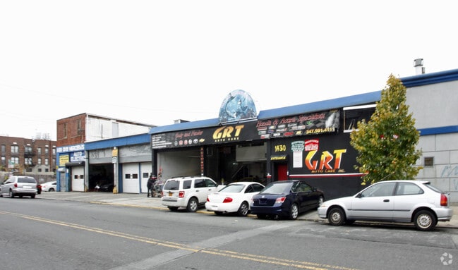

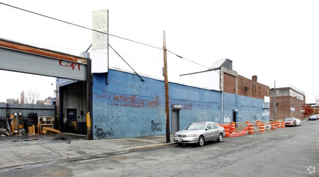
Property Detail
1095 Close Ave
03709-0040
Bronx
Autorepair
New York
M1-1
40
B and X Area of moderate flood hazard, usually the area between the limits of the 100-year and 500-year floods.
1.36 AC
2024
Bronx
2025
Westchester/So Connecticut
005200
New York-Jersey City-White Plains, NY-NJ
10,000 SF
NEARBY LISTINGS FOR SALE OR LEASE
DEMOGRAPHICS near 1095 Close Ave
1 mile
3 mile
5 mile
2025 Total Population
141,844
974,639
2,320,341
2030 Population
138,545
955,517
2,314,418
Pop Growth 2025-2030
(2.33%)
(1.96%)
(0.26%)
Average Age
37
38
40
2025 Total Households
48,470
335,692
868,394
HH Growth 2025-2030
(2.76%)
(2.34%)
(0.13%)
Median Household Inc
$36,832
$40,998
$56,750
Avg Household Size
2.80
2.70
2.50
2025 Avg HH Vehicles
.00
.00
.00
Median Home Value
$637,843
$562,122
$647,975
Median Year Built
1959
1955
1953
Nearby Places
Map Layers
Map Styles
 Street
 Aerial
Transit
 Traffic
 Biking
Places
Listings with unknown addresses are not visible on the map
- Restaurants
- Banks
- Shops
- Fitness
- Groceries
Nearby Properties
Address
Land Use
TOTAL SIZE
Lot Size
Zoning
Address
Land Use
TOTAL SIZE
Lot Size
Zoning
5,519,372 SF
409.21 AC
C8-2
Address
Land Use
TOTAL SIZE
Lot Size
Zoning
1,743,584 SF
77.87 AC
R6
Address
Land Use
TOTAL SIZE
Lot Size
Zoning
1,427,393 SF
39.94 AC
R4
Address
Land Use
TOTAL SIZE
Lot Size
Zoning
481,172 SF
205.58 AC
PARK
Address
Land Use
TOTAL SIZE
Lot Size
Zoning
1,311,800 SF
9.89 AC
C4-4
Address
Land Use
TOTAL SIZE
Lot Size
Zoning
207.09 AC
PARK
Address
Land Use
TOTAL SIZE
Lot Size
Zoning
1,012,000 SF
7.79 AC
R6
Address
Land Use
TOTAL SIZE
Lot Size
Zoning
892,550 SF
2.93 AC
M13R8
Address
Land Use
TOTAL SIZE
Lot Size
Zoning
667,405 SF
5.51 AC
R6
Address
Land Use
TOTAL SIZE
Lot Size
Zoning
2,531,670 SF
17.15 AC
R7-2
Address
Land Use
TOTAL SIZE
Lot Size
Zoning
390,750 SF
265 AC
PARK
Address
Land Use
TOTAL SIZE
Lot Size
Zoning
631,237 SF
30.93 AC
R5
Address
Land Use
TOTAL SIZE
Lot Size
Zoning
480,769 SF
1.21 AC
R8
Address
Land Use
TOTAL SIZE
Lot Size
Zoning
1,392,950 SF
19.67 AC
M2-1
Address
Land Use
TOTAL SIZE
Lot Size
Zoning
293,848 SF
2.98 AC
C8-3
Address
Land Use
TOTAL SIZE
Lot Size
Zoning
851,821 SF
7.95 AC
R4
Address
Land Use
TOTAL SIZE
Lot Size
Zoning
426,172 SF
14.30 AC
M3-1
Address
Land Use
TOTAL SIZE
Lot Size
Zoning
491,007 SF
11.85 AC
M3-1
Address
Land Use
TOTAL SIZE
Lot Size
Zoning
566,233 SF
13.25 AC
M3-1
Address
Land Use
TOTAL SIZE
Lot Size
Zoning
291,885 SF
8.86 AC
R8
Address
Land Use
TOTAL SIZE
Lot Size
Zoning
14,681 SF
97 AC
PARK
Address
Land Use
TOTAL SIZE
Lot Size
Zoning
127,000 SF
16.53 AC
M3-1
Address
Land Use
TOTAL SIZE
Lot Size
Zoning
447,145 SF
8.05 AC
M3-1
Address
Land Use
TOTAL SIZE
Lot Size
Zoning
489,326 SF
19.18 AC
C8-1
Address
Land Use
TOTAL SIZE
Lot Size
Zoning
245,002 SF
9.12 AC
C8-3
Address
Land Use
TOTAL SIZE
Lot Size
Zoning
224,037 SF
0.82 AC
C45X
Address
Land Use
TOTAL SIZE
Lot Size
Zoning
238,500 SF
1.13 AC
C4-4
Address
Land Use
TOTAL SIZE
Lot Size
Zoning
361,354 SF
C4-2
Address
Land Use
TOTAL SIZE
Lot Size
Zoning
340,364 SF
4.10 AC
C4-6
Address
Land Use
TOTAL SIZE
Lot Size
Zoning
429,149 SF
4.79 AC
C4-4
The World's #1 Commercial Real Estate Marketplace
Connect with us
© 2026 CoStar Group
The information above has been obtained from sources believed reliable. While we do not doubt its accuracy we have not verified it and make no guarantee, warranty or representation about it. It is your responsibility to independently confirm its accuracy and completeness. Any projections, opinions, assumptions, or estimates used are for example only and do not represent the current or future performance of the property. The value of this transaction to you depends on tax and other factors which should be evaluated by your tax, financial, and legal advisors. You and your advisors should conduct a careful, independent investigation of the property to determine to your satisfaction the suitability of the property for your needs.