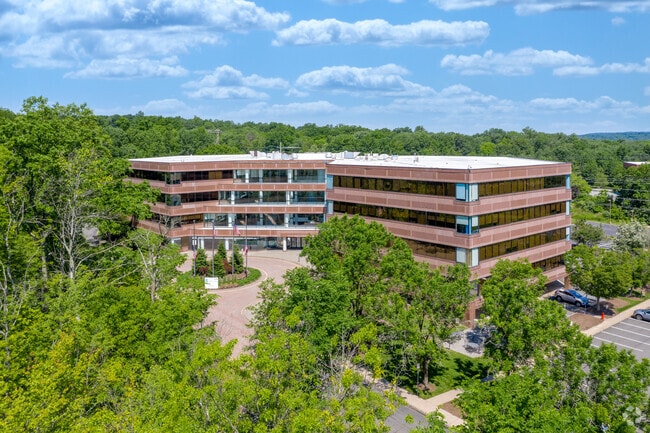
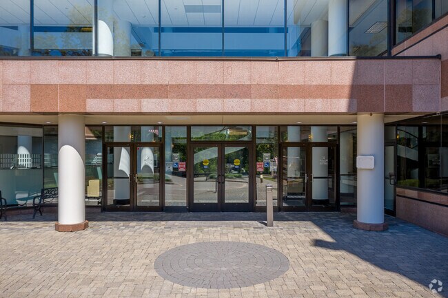
Property Record
110 Allen Rd, Basking Ridge, NJ 07920


Current Lease Availabilities
Property Detail
110 Allen Rd
Lakewood-New Brunswick, NJ
ADDITIONAL LOTS: 201781 SF NET 212000 GROSS
02-11201-0000-00015
Somerset
Officebuilding
New Jersey
E2
15
B and X Area of moderate flood hazard, usually the area between the limits of the 100-year and 500-year floods.
25.64 AC
2024
Route 78 East
2025
Northern New Jersey
052604
NEARBY LISTINGS FOR SALE OR LEASE
DEMOGRAPHICS near 110 Allen Rd
1 mile
3 mile
5 mile
2025 Total Population
1,924
36,460
79,163
2030 Population
1,986
37,802
82,087
Pop Growth 2025-2030
+ 3.22%
+ 3.68%
+ 3.69%
Average Age
43
44
43
2025 Total Households
791
14,243
29,455
HH Growth 2025-2030
+ 3.41%
+ 3.87%
+ 3.87%
Median Household Inc
$153,218
$171,021
$180,103
Avg Household Size
2.30
2.50
2.60
2025 Avg HH Vehicles
2.00
2.00
2.00
Median Home Value
$553,125
$733,725
$763,062
Median Year Built
1987
1986
1983
Nearby Places
Map Layers
Map Styles
 Street
 Aerial
Transit
 Traffic
 Biking
Places
Listings with unknown addresses are not visible on the map
- Restaurants
- Banks
- Shops
- Fitness
- Groceries
Nearby Properties
Address
Land Use
TOTAL SIZE
Lot Size
Zoning
Address
Land Use
TOTAL SIZE
Lot Size
Zoning
Address
Land Use
TOTAL SIZE
Lot Size
Zoning
294,624 SF
56.79 AC
R2
Address
Land Use
TOTAL SIZE
Lot Size
Zoning
155.97 AC
P4
Address
Land Use
TOTAL SIZE
Lot Size
Zoning
206,077 SF
22.03 AC
B5
Address
Land Use
TOTAL SIZE
Lot Size
Zoning
141.44 AC
P4
Address
Land Use
TOTAL SIZE
Lot Size
Zoning
85,000 SF
25.62 AC
E3
Address
Land Use
TOTAL SIZE
Lot Size
Zoning
46.96 AC
OR
Address
Land Use
TOTAL SIZE
Lot Size
Zoning
115.79 AC
OR
Address
Land Use
TOTAL SIZE
Lot Size
Zoning
15 AC
R2
Address
Land Use
TOTAL SIZE
Lot Size
Zoning
146.60 AC
SED
Address
Land Use
TOTAL SIZE
Lot Size
Zoning
7,082 SF
10 AC
R3
Address
Land Use
TOTAL SIZE
Lot Size
Zoning
2,848 SF
22.47 AC
ORVM
Address
Land Use
TOTAL SIZE
Lot Size
Zoning
17.63 AC
OR
Address
Land Use
TOTAL SIZE
Lot Size
Zoning
Address
Land Use
TOTAL SIZE
Lot Size
Zoning
68,160 SF
11.66 AC
R6
Address
Land Use
TOTAL SIZE
Lot Size
Zoning
1,096 SF
15.12 AC
R5
Address
Land Use
TOTAL SIZE
Lot Size
Zoning
12.94 AC
SED
Address
Land Use
TOTAL SIZE
Lot Size
Zoning
126,360 SF
36.03 AC
E3
Address
Land Use
TOTAL SIZE
Lot Size
Zoning
31.58 AC
OR
Address
Land Use
TOTAL SIZE
Lot Size
Zoning
13.07 AC
OR
Address
Land Use
TOTAL SIZE
Lot Size
Zoning
1,428 SF
19.52 AC
E2
Address
Land Use
TOTAL SIZE
Lot Size
Zoning
61,059 SF
9.10 AC
R6
Address
Land Use
TOTAL SIZE
Lot Size
Zoning
62,250 SF
14.43 AC
E2
Address
Land Use
TOTAL SIZE
Lot Size
Zoning
15.22 AC
OR
Address
Land Use
TOTAL SIZE
Lot Size
Zoning
34.61 AC
E3
Address
Land Use
TOTAL SIZE
Lot Size
Zoning
93,035 SF
41.85 AC
R1
Address
Land Use
TOTAL SIZE
Lot Size
Zoning
12 AC
P3
Address
Land Use
TOTAL SIZE
Lot Size
Zoning
5.71 AC
OR
Address
Land Use
TOTAL SIZE
Lot Size
Zoning
128,856 SF
7.98 AC
E3
The World's #1 Commercial Real Estate Marketplace
Connect with us
© 2026 CoStar Group
The information above has been obtained from sources believed reliable. While we do not doubt its accuracy we have not verified it and make no guarantee, warranty or representation about it. It is your responsibility to independently confirm its accuracy and completeness. Any projections, opinions, assumptions, or estimates used are for example only and do not represent the current or future performance of the property. The value of this transaction to you depends on tax and other factors which should be evaluated by your tax, financial, and legal advisors. You and your advisors should conduct a careful, independent investigation of the property to determine to your satisfaction the suitability of the property for your needs.