Property Record
1100 42Nd St, Evans, CO 80620
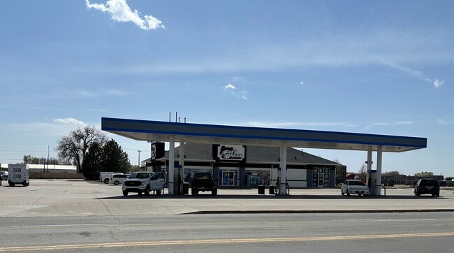

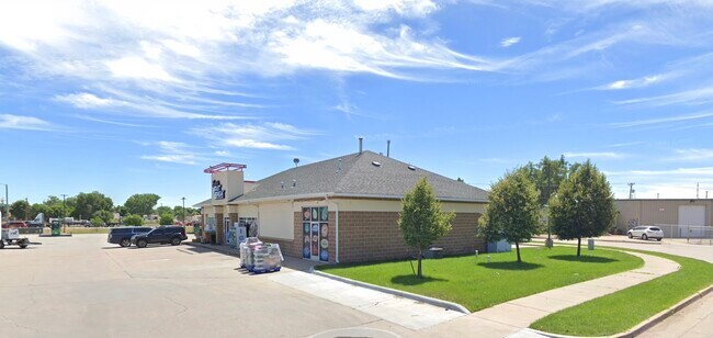
Property Detail
1100 42Nd St
Greeley, CO
EVS WER L1 WERNSMAN
R2448203
Weld
Commercialnec
Colorado
B and X Area of moderate flood hazard, usually the area between the limits of the 100-year and 500-year floods.
1
2024
1.03 AC
2025
Greeley
001005
Denver
4,140 SF
NEARBY LISTINGS FOR SALE OR LEASE
DEMOGRAPHICS near 1100 42Nd St
1 mile
3 mile
5 mile
2024 Total Population
6,844
69,555
129,308
2029 Population
7,410
76,858
142,469
Pop Growth 2024-2029
+ 8.27%
+ 10.50%
+ 10.18%
Average Age
37
34
36
2024 Total Households
2,406
24,048
46,216
HH Growth 2024-2029
+ 8.40%
+ 11.30%
+ 10.84%
Median Household Inc
$59,982
$60,455
$62,491
Avg Household Size
2.80
2.70
2.70
2024 Avg HH Vehicles
2.00
2.00
2.00
Median Home Value
$328,960
$344,420
$362,406
Median Year Built
1984
1990
1985
Nearby Places
Map Layers
Map Styles
 Street
 Aerial
Transit
 Traffic
 Biking
Places
Listings with unknown addresses are not visible on the map
- Restaurants
- Banks
- Shops
- Fitness
- Groceries
SALE & LEASE HISTORY
LISTING DATE
SALE/LEASE

May 01, 2025
For Sale
Feb 04, 2020
For Sale
Aug 08, 2018
For Sale
Nearby Properties
Address
Land Use
TOTAL SIZE
Lot Size
Zoning
Address
Land Use
TOTAL SIZE
Lot Size
Zoning
1,682,342 SF
134.62 AC
Address
Land Use
TOTAL SIZE
Lot Size
Zoning
280,000 SF
43.91 AC
Address
Land Use
TOTAL SIZE
Lot Size
Zoning
536,281 SF
33.91 AC
Address
Land Use
TOTAL SIZE
Lot Size
Zoning
237,575 SF
10.77 AC
Address
Land Use
TOTAL SIZE
Lot Size
Zoning
150,693 SF
20 AC
Address
Land Use
TOTAL SIZE
Lot Size
Zoning
219,178 SF
22.28 AC
Address
Land Use
TOTAL SIZE
Lot Size
Zoning
309,821 SF
13.55 AC
Address
Land Use
TOTAL SIZE
Lot Size
Zoning
202,130 SF
25.35 AC
Address
Land Use
TOTAL SIZE
Lot Size
Zoning
405,388 SF
17.36 AC
Address
Land Use
TOTAL SIZE
Lot Size
Zoning
239,925 SF
6.06 AC
Address
Land Use
TOTAL SIZE
Lot Size
Zoning
75,376 SF
11.70 AC
Address
Land Use
TOTAL SIZE
Lot Size
Zoning
114,879 SF
27.73 AC
Address
Land Use
TOTAL SIZE
Lot Size
Zoning
144,758 SF
18.99 AC
Address
Land Use
TOTAL SIZE
Lot Size
Zoning
13,704 SF
3.91 AC
Address
Land Use
TOTAL SIZE
Lot Size
Zoning
73,945 SF
3.21 AC
Address
Land Use
TOTAL SIZE
Lot Size
Zoning
202,085 SF
9.78 AC
Address
Land Use
TOTAL SIZE
Lot Size
Zoning
60,672 SF
10 AC
Address
Land Use
TOTAL SIZE
Lot Size
Zoning
170,991 SF
8.92 AC
Address
Land Use
TOTAL SIZE
Lot Size
Zoning
49,488 SF
46.63 AC
Address
Land Use
TOTAL SIZE
Lot Size
Zoning
114,213 SF
9.91 AC
Address
Land Use
TOTAL SIZE
Lot Size
Zoning
208,944 SF
7.72 AC
Address
Land Use
TOTAL SIZE
Lot Size
Zoning
45,473 SF
5.40 AC
Address
Land Use
TOTAL SIZE
Lot Size
Zoning
198,035 SF
9.94 AC
Address
Land Use
TOTAL SIZE
Lot Size
Zoning
69,526 SF
7.40 AC
Address
Land Use
TOTAL SIZE
Lot Size
Zoning
93,750 SF
8.03 AC
Address
Land Use
TOTAL SIZE
Lot Size
Zoning
43,168 SF
4.99 AC
Address
Land Use
TOTAL SIZE
Lot Size
Zoning
43,821 SF
4 AC
Address
Land Use
TOTAL SIZE
Lot Size
Zoning
90,880 SF
8.46 AC
Address
Land Use
TOTAL SIZE
Lot Size
Zoning
113,218 SF
10.23 AC
Address
Land Use
TOTAL SIZE
Lot Size
Zoning
321,331 SF
15.63 AC
The World's #1 Commercial Real Estate Marketplace
Connect with us
© 2026 CoStar Group
The information above has been obtained from sources believed reliable. While we do not doubt its accuracy we have not verified it and make no guarantee, warranty or representation about it. It is your responsibility to independently confirm its accuracy and completeness. Any projections, opinions, assumptions, or estimates used are for example only and do not represent the current or future performance of the property. The value of this transaction to you depends on tax and other factors which should be evaluated by your tax, financial, and legal advisors. You and your advisors should conduct a careful, independent investigation of the property to determine to your satisfaction the suitability of the property for your needs.