Property Record
1101 Eldert Lane, Brooklyn, NY 11208
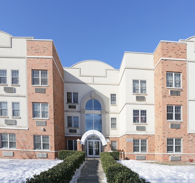
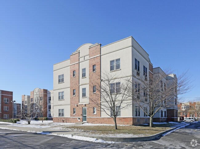
Property Detail
1101 Eldert Lane
04571-0001
KINGS
Apartment
New York
R4
1
AE The base floodplain where base flood elevations are provided. AE Zones are now used on new format FIRMs instead of A1-A30 Zones.
1.24 AC
0
Spring Creek
2026
Long Island (New York)
119600
New York-Jersey City-White Plains, NY-NJ
37,765 SF
NEARBY LISTINGS FOR SALE OR LEASE
DEMOGRAPHICS near 1101 Eldert Lane
1 mile
3 mile
5 mile
2025 Total Population
54,832
511,259
1,670,475
2030 Population
53,848
491,573
1,632,445
Pop Growth 2025-2030
(1.79%)
(3.85%)
(2.28%)
Average Age
41
40
41
2025 Total Households
19,905
164,937
585,059
HH Growth 2025-2030
(1.94%)
(4.26%)
(2.55%)
Median Household Inc
$60,617
$64,937
$73,820
Avg Household Size
2.70
2.90
2.70
2025 Avg HH Vehicles
1.00
1.00
1.00
Median Home Value
$554,387
$709,404
$723,364
Median Year Built
1965
1951
1949
Nearby Places
Map Layers
Map Styles
 Street
 Aerial
Layers
 Traffic
 Biking
Places
Listings with unknown addresses are not visible on the map
- Restaurants
- Banks
- Shops
- Fitness
- Groceries
PUBLIC TRANSPORTATION
COMMUTER RAIL
Kew Gardens Station (Babylon Branch - Long Island Rail Road, Hempstead Branch - Long Island Rail Road, Long Beach Branch - Long Island Rail Road, Port Jefferson Branch - Long Island Rail Road)
Drive
Walk
Distance
Kew Gardens Station (Babylon Branch - Long Island Rail Road, Hempstead Branch - Long Island Rail Road, Long Beach Branch - Long Island Rail Road, Port Jefferson Branch - Long Island Rail Road)
14 min
5.6 mi
East New York Station (Far Rockaway Branch - Long Island Rail Road, Long Beach Branch - Long Island Rail Road, West Hempstead Branch - Long Island Rail Road)
Drive
Walk
Distance
East New York Station (Far Rockaway Branch - Long Island Rail Road, Long Beach Branch - Long Island Rail Road, West Hempstead Branch - Long Island Rail Road)
11 min
5.7 mi
AIRPORT
John F Kennedy International
Drive
Walk
Distance
John F Kennedy International
11 min
6.5 mi
LaGuardia
Drive
Walk
Distance
LaGuardia
23 min
13.3 mi
Newark Liberty International
Drive
Walk
Distance
Newark Liberty International
44 min
24.8 mi
Freight Ports
NY - Red Hook Container Terminal
Drive
Walk
Distance
NY - Red Hook Container Terminal
20 min
10.3 mi
Nearby Properties
Address
Land Use
TOTAL SIZE
Lot Size
Zoning
Address
Land Use
TOTAL SIZE
Lot Size
Zoning
477.04 AC
PARKUS
Address
Land Use
TOTAL SIZE
Lot Size
Zoning
266.30 AC
PARK
Address
Land Use
TOTAL SIZE
Lot Size
Zoning
1,845,252 SF
172 AC
C8-1
Address
Land Use
TOTAL SIZE
Lot Size
Zoning
104 AC
PARK
Address
Land Use
TOTAL SIZE
Lot Size
Zoning
54,170 SF
229.57 AC
PARK
Address
Land Use
TOTAL SIZE
Lot Size
Zoning
5,302 SF
366.15 AC
PARK
Address
Land Use
TOTAL SIZE
Lot Size
Zoning
1,688,760 SF
24.65 AC
R5
Address
Land Use
TOTAL SIZE
Lot Size
Zoning
1,526,800 SF
32.39 AC
R5
Address
Land Use
TOTAL SIZE
Lot Size
Zoning
600 SF
33.07 AC
PARK
Address
Land Use
TOTAL SIZE
Lot Size
Zoning
126.85 AC
PARK
Address
Land Use
TOTAL SIZE
Lot Size
Zoning
1,493,793 SF
14.19 AC
R5
Address
Land Use
TOTAL SIZE
Lot Size
Zoning
6,000 SF
110.42 AC
PARK
Address
Land Use
TOTAL SIZE
Lot Size
Zoning
1,420,000 SF
19.61 AC
R5
Address
Land Use
TOTAL SIZE
Lot Size
Zoning
1,485,000 SF
20.28 AC
R5
Address
Land Use
TOTAL SIZE
Lot Size
Zoning
511,776 SF
2.33 AC
R6
Address
Land Use
TOTAL SIZE
Lot Size
Zoning
363,548 SF
1.81 AC
Address
Land Use
TOTAL SIZE
Lot Size
Zoning
333,424 SF
1.78 AC
C45D
Address
Land Use
TOTAL SIZE
Lot Size
Zoning
24,400 SF
33.98 AC
C4-2
Address
Land Use
TOTAL SIZE
Lot Size
Zoning
28.64 AC
PARK
Address
Land Use
TOTAL SIZE
Lot Size
Zoning
1,136,208 SF
30.25 AC
R5
Address
Land Use
TOTAL SIZE
Lot Size
Zoning
997,720 SF
8.23 AC
R5
Address
Land Use
TOTAL SIZE
Lot Size
Zoning
4,761.05 AC
PARK
Address
Land Use
TOTAL SIZE
Lot Size
Zoning
158,402 SF
3.64 AC
C4-2
Address
Land Use
TOTAL SIZE
Lot Size
Zoning
940,800 SF
11.55 AC
R5
Address
Land Use
TOTAL SIZE
Lot Size
Zoning
230,580 SF
3.41 AC
C8-1
Address
Land Use
TOTAL SIZE
Lot Size
Zoning
203,132 SF
3.09 AC
C4-2
Address
Land Use
TOTAL SIZE
Lot Size
Zoning
1,622,073 SF
10.69 AC
R6
Address
Land Use
TOTAL SIZE
Lot Size
Zoning
29.68 AC
C4-2
Address
Land Use
TOTAL SIZE
Lot Size
Zoning
279,162 SF
9.90 AC
M1-1
Address
Land Use
TOTAL SIZE
Lot Size
Zoning
552,216 SF
9.41 AC
R4
The World's #1 Commercial Real Estate Marketplace
Connect with us
© 2026 CoStar Group
The information above has been obtained from sources believed reliable. While we do not doubt its accuracy we have not verified it and make no guarantee, warranty or representation about it. It is your responsibility to independently confirm its accuracy and completeness. Any projections, opinions, assumptions, or estimates used are for example only and do not represent the current or future performance of the property. The value of this transaction to you depends on tax and other factors which should be evaluated by your tax, financial, and legal advisors. You and your advisors should conduct a careful, independent investigation of the property to determine to your satisfaction the suitability of the property for your needs.