Property Record
1104 Valley Rd, Menasha, WI 54952

Save to a Folder
{{folder.Name}}
{{folder.ListingIds.length}} Properties
{{folder.ListingIds.length}} Property
Create a New Folder
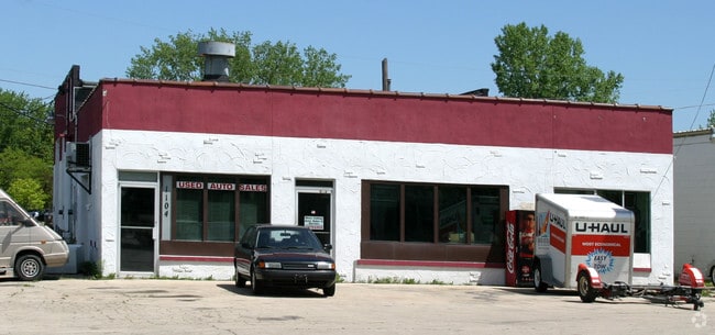
Property Detail
1104 Valley Rd
Oshkosh-Neenah, WI
BALDWIN HEIGHTS LOT 7 BLK 6 .16 A.
008-0977
WINNEBAGO
Commercialnec
Wisconsin
B3
7
B and X Area of moderate flood hazard, usually the area between the limits of the 100-year and 500-year floods.
0.17 AC
2024
Appleton/Oshkosh
2025
Other Market Areas
002500
NEARBY LISTINGS FOR SALE OR LEASE
DEMOGRAPHICS near 1104 Valley Rd
1 mile
3 mile
5 mile
2025 Total Population
8,935
80,458
156,384
2030 Population
9,036
81,863
159,196
Pop Growth 2025-2030
+ 1.13%
+ 1.75%
+ 1.80%
Average Age
40
39
40
2025 Total Households
3,968
34,087
65,590
HH Growth 2025-2030
+ 1.06%
+ 1.91%
+ 1.86%
Median Household Inc
$61,061
$69,179
$76,385
Avg Household Size
2.20
2.20
2.30
2025 Avg HH Vehicles
2.00
2.00
2.00
Median Home Value
$247,431
$210,688
$237,050
Median Year Built
1975
1970
1975
Nearby Places
Map Layers
Map Styles
 Street
 Aerial
Layers
 Traffic
 Biking
Places
Listings with unknown addresses are not visible on the map
- Restaurants
- Banks
- Shops
- Fitness
- Groceries
PUBLIC TRANSPORTATION
AIRPORT
Appleton International
Drive
Walk
Distance
Appleton International
14 min
8.0 mi
Green Bay/Austin Straubel International
Drive
Walk
Distance
Green Bay/Austin Straubel International
39 min
30.2 mi
Nearby Properties
Address
Land Use
TOTAL SIZE
Lot Size
Zoning
Address
Land Use
TOTAL SIZE
Lot Size
Zoning
8.61 AC
R5
Address
Land Use
TOTAL SIZE
Lot Size
Zoning
46,300 SF
23.21 AC
M2
Address
Land Use
TOTAL SIZE
Lot Size
Zoning
207,455 SF
3.42 AC
PDC2
Address
Land Use
TOTAL SIZE
Lot Size
Zoning
267,069 SF
26.76 AC
Address
Land Use
TOTAL SIZE
Lot Size
Zoning
17.51 AC
Address
Land Use
TOTAL SIZE
Lot Size
Zoning
278,801 SF
20.94 AC
Address
Land Use
TOTAL SIZE
Lot Size
Zoning
20.37 AC
PDC2
Address
Land Use
TOTAL SIZE
Lot Size
Zoning
191,466 SF
1.21 AC
CBD
Address
Land Use
TOTAL SIZE
Lot Size
Zoning
249,444 SF
18.81 AC
Address
Land Use
TOTAL SIZE
Lot Size
Zoning
11,340 SF
0.92 AC
C2
Address
Land Use
TOTAL SIZE
Lot Size
Zoning
29,742 SF
5.95 AC
R3
Address
Land Use
TOTAL SIZE
Lot Size
Zoning
53,321 SF
2.51 AC
CBD
Address
Land Use
TOTAL SIZE
Lot Size
Zoning
44,164 SF
0.62 AC
CBD
Address
Land Use
TOTAL SIZE
Lot Size
Zoning
17.43 AC
M2
Address
Land Use
TOTAL SIZE
Lot Size
Zoning
25.59 AC
Address
Land Use
TOTAL SIZE
Lot Size
Zoning
23,134 SF
0.08 AC
Address
Land Use
TOTAL SIZE
Lot Size
Zoning
20.92 AC
R5
Address
Land Use
TOTAL SIZE
Lot Size
Zoning
146,812 SF
8.93 AC
R3
Address
Land Use
TOTAL SIZE
Lot Size
Zoning
25.62 AC
I2
Address
Land Use
TOTAL SIZE
Lot Size
Zoning
20,874 SF
11.57 AC
R4
Address
Land Use
TOTAL SIZE
Lot Size
Zoning
205,111 SF
18.40 AC
PDC2
Address
Land Use
TOTAL SIZE
Lot Size
Zoning
161,991 SF
0.30 AC
Address
Land Use
TOTAL SIZE
Lot Size
Zoning
5,394 SF
0.30 AC
CBD
Address
Land Use
TOTAL SIZE
Lot Size
Zoning
62,673 SF
3.19 AC
PDC2
Address
Land Use
TOTAL SIZE
Lot Size
Zoning
21,540 SF
0.79 AC
CBD
Address
Land Use
TOTAL SIZE
Lot Size
Zoning
42,402 SF
3.39 AC
Address
Land Use
TOTAL SIZE
Lot Size
Zoning
6,540 SF
0.15 AC
CBD
Address
Land Use
TOTAL SIZE
Lot Size
Zoning
25,705 SF
2.03 AC
PDR3
Address
Land Use
TOTAL SIZE
Lot Size
Zoning
112,030 SF
9.23 AC
Address
Land Use
TOTAL SIZE
Lot Size
Zoning
92,296 SF
13.33 AC
R1
The World's #1 Commercial Real Estate Marketplace
Connect with us
© 2026 CoStar Group
The information above has been obtained from sources believed reliable. While we do not doubt its accuracy we have not verified it and make no guarantee, warranty or representation about it. It is your responsibility to independently confirm its accuracy and completeness. Any projections, opinions, assumptions, or estimates used are for example only and do not represent the current or future performance of the property. The value of this transaction to you depends on tax and other factors which should be evaluated by your tax, financial, and legal advisors. You and your advisors should conduct a careful, independent investigation of the property to determine to your satisfaction the suitability of the property for your needs.