Property Record
111 2Nd St, Sausalito, CA 94965
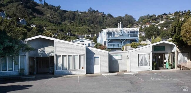


This Property Is For Sale
Property Detail
111 2Nd St
San Rafael, CA
L4-6* B6 /B3P86 OR #3 SAUSALITO BAY LA
065-267-37
Marin
Commercialnec
California
B and X Area of moderate flood hazard, usually the area between the limits of the 100-year and 500-year floods.
4-6
2025
0.23 AC
2025
Corte Madera/Mill Valley
130201
North Bay/Santa Rosa
4,050 SF
NEARBY LISTINGS FOR SALE OR LEASE
DEMOGRAPHICS near 111 2Nd St
1 mile
3 mile
5 mile
2025 Total Population
4,832
18,856
177,223
2030 Population
4,811
18,745
179,397
Pop Growth 2025-2030
(0.43%)
(0.59%)
+ 1.23%
Average Age
52
49
43
2025 Total Households
2,615
9,098
82,702
HH Growth 2025-2030
(0.57%)
(0.75%)
+ 1.28%
Median Household Inc
$177,601
$164,007
$172,510
Avg Household Size
1.80
2.00
2.10
2025 Avg HH Vehicles
2.00
2.00
1.00
Median Home Value
$1,139,295
$1,122,340
$1,122,649
Median Year Built
1950
1966
1950
Nearby Places
Map Layers
Map Styles
 Street
 Aerial
Transit
 Traffic
 Biking
Places
Listings with unknown addresses are not visible on the map
- Restaurants
- Banks
- Shops
- Fitness
- Groceries
PUBLIC TRANSPORTATION
COMMUTER RAIL
San Francisco 4th & King (Caltrain - Caltrain (Caltrain))
Drive
Walk
Distance
San Francisco 4th & King (Caltrain - Caltrain (Caltrain))
26 min
9.5 mi
AIRPORT
San Francisco International
Drive
Walk
Distance
San Francisco International
36 min
21.2 mi
Metro Oakland International
Drive
Walk
Distance
Metro Oakland International
48 min
27.3 mi
Freight Ports
Port of San Francisco
Drive
Walk
Distance
Port of San Francisco
1 min
5.9 mi
Nearby Properties
Address
Land Use
TOTAL SIZE
Lot Size
Zoning
Address
Land Use
TOTAL SIZE
Lot Size
Zoning
115,264 SF
6.29 AC
Address
Land Use
TOTAL SIZE
Lot Size
Zoning
175,913 SF
19.81 AC
Address
Land Use
TOTAL SIZE
Lot Size
Zoning
100,000 SF
6.30 AC
Address
Land Use
TOTAL SIZE
Lot Size
Zoning
54,424 SF
2.31 AC
Address
Land Use
TOTAL SIZE
Lot Size
Zoning
83,323 SF
7.58 AC
Address
Land Use
TOTAL SIZE
Lot Size
Zoning
72,126 SF
4.36 AC
Address
Land Use
TOTAL SIZE
Lot Size
Zoning
85,883 SF
3.52 AC
Address
Land Use
TOTAL SIZE
Lot Size
Zoning
79,070 SF
3.85 AC
Address
Land Use
TOTAL SIZE
Lot Size
Zoning
31,645 SF
0.61 AC
Address
Land Use
TOTAL SIZE
Lot Size
Zoning
25,517 SF
13.29 AC
Address
Land Use
TOTAL SIZE
Lot Size
Zoning
19,363 SF
2.83 AC
Address
Land Use
TOTAL SIZE
Lot Size
Zoning
66,197 SF
3.60 AC
Address
Land Use
TOTAL SIZE
Lot Size
Zoning
3.53 AC
Address
Land Use
TOTAL SIZE
Lot Size
Zoning
20,352 SF
0.63 AC
Address
Land Use
TOTAL SIZE
Lot Size
Zoning
33,332 SF
1.29 AC
Address
Land Use
TOTAL SIZE
Lot Size
Zoning
Address
Land Use
TOTAL SIZE
Lot Size
Zoning
29,392 SF
0.45 AC
Address
Land Use
TOTAL SIZE
Lot Size
Zoning
15,166 SF
0.63 AC
Address
Land Use
TOTAL SIZE
Lot Size
Zoning
1.05 AC
Address
Land Use
TOTAL SIZE
Lot Size
Zoning
43,227 SF
1 AC
Address
Land Use
TOTAL SIZE
Lot Size
Zoning
103,284 SF
1.90 AC
Address
Land Use
TOTAL SIZE
Lot Size
Zoning
Address
Land Use
TOTAL SIZE
Lot Size
Zoning
2.72 AC
Address
Land Use
TOTAL SIZE
Lot Size
Zoning
Address
Land Use
TOTAL SIZE
Lot Size
Zoning
13,125 SF
0.28 AC
Address
Land Use
TOTAL SIZE
Lot Size
Zoning
1.96 AC
Address
Land Use
TOTAL SIZE
Lot Size
Zoning
Address
Land Use
TOTAL SIZE
Lot Size
Zoning
26,940 SF
1.21 AC
Address
Land Use
TOTAL SIZE
Lot Size
Zoning
6,516 SF
0.55 AC
Address
Land Use
TOTAL SIZE
Lot Size
Zoning
18,388 SF
0.55 AC
The World's #1 Commercial Real Estate Marketplace
Connect with us
© 2026 CoStar Group
The information above has been obtained from sources believed reliable. While we do not doubt its accuracy we have not verified it and make no guarantee, warranty or representation about it. It is your responsibility to independently confirm its accuracy and completeness. Any projections, opinions, assumptions, or estimates used are for example only and do not represent the current or future performance of the property. The value of this transaction to you depends on tax and other factors which should be evaluated by your tax, financial, and legal advisors. You and your advisors should conduct a careful, independent investigation of the property to determine to your satisfaction the suitability of the property for your needs.