Property Record
111 Coopers Ridge Blvd, Ladson, SC 29456


NEARBY LISTINGS FOR SALE OR LEASE
-
-
View all Ladson listings for sale on LoopNet.com
Property Detail
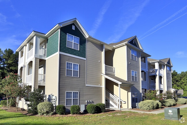
111 Coopers Ridge Blvd
154-00-00-067
Coopers Ridge Apt
Apartment
TRACT 2 SUBD: COOPERS RIDGE APT
X
Dorchester
45019C0260K
South Carolina
2025
26.90 AC
2025
Summerville
010815
Charleston/N Charleston
299,616 SF
Charleston-North Charleston, SC
DEMOGRAPHICS near 111 Coopers Ridge Blvd
1 Mile
3 Mile
5 Mile
2024 Total Population
10,486
63,018
157,039
2029 Population
11,235
67,974
172,369
Pop Growth 2024-2029
+ 7.14%
+ 7.86%
+ 9.76%
Average Age
36
37
38
2024 Total Households
4,065
24,225
59,945
HH Growth 2024-2029
+ 7.01%
+ 7.72%
+ 9.58%
Median Household Inc
$71,124
$69,426
$70,180
Avg Household Size
2.50
2.60
2.50
2024 Avg HH Vehicles
2.00
2.00
2.00
Median Home Value
$206,954
$248,825
$249,578
Median Year Built
2002
2001
1997
Nearby Places
Map Layers
Map Styles
 Street
 Aerial
- Restaurants
- Banks
- Shops
- Fitness
- Groceries
PUBLIC TRANSPORTATION
AIRPORT
Charleston AFB/International
DRIVE
WALK
Distance
Charleston AFB/International
16 min
10.7 mi
Freight Ports
North Charleston Terminal
DRIVE
WALK
Distance
North Charleston Terminal
19 min
12.7 mi
Nearby Properties
Address
Land Use
TOTAL SIZE
Lot Size
Zoning
Address
Land Use
TOTAL SIZE
Lot Size
Zoning
Address
Land Use
TOTAL SIZE
Lot Size
Zoning
1,520 SF
12 AC
BERKELEY C
Address
Land Use
TOTAL SIZE
Lot Size
Zoning
48.89 AC
Address
Land Use
TOTAL SIZE
Lot Size
Zoning
1,430 SF
28.27 AC
Address
Land Use
TOTAL SIZE
Lot Size
Zoning
182,112 SF
38.64 AC
Address
Land Use
TOTAL SIZE
Lot Size
Zoning
152,460 SF
26.94 AC
Address
Land Use
TOTAL SIZE
Lot Size
Zoning
28,770 SF
15.53 AC
Address
Land Use
TOTAL SIZE
Lot Size
Zoning
14.75 AC
Address
Land Use
TOTAL SIZE
Lot Size
Zoning
16.40 AC
Address
Land Use
TOTAL SIZE
Lot Size
Zoning
16.53 AC
Address
Land Use
TOTAL SIZE
Lot Size
Zoning
1,272 SF
18.46 AC
Address
Land Use
TOTAL SIZE
Lot Size
Zoning
Address
Land Use
TOTAL SIZE
Lot Size
Zoning
33.62 AC
Address
Land Use
TOTAL SIZE
Lot Size
Zoning
14.33 AC
Address
Land Use
TOTAL SIZE
Lot Size
Zoning
181,427 SF
16.47 AC
Address
Land Use
TOTAL SIZE
Lot Size
Zoning
194,515 SF
26.73 AC
Address
Land Use
TOTAL SIZE
Lot Size
Zoning
30,790 SF
7.59 AC
BERKELEY C
Address
Land Use
TOTAL SIZE
Lot Size
Zoning
Address
Land Use
TOTAL SIZE
Lot Size
Zoning
124,678 SF
65.93 AC
Address
Land Use
TOTAL SIZE
Lot Size
Zoning
13,620 SF
9.44 AC
BERKELEY C
Address
Land Use
TOTAL SIZE
Lot Size
Zoning
33,884 SF
10.49 AC
NORTH CHAR
Address
Land Use
TOTAL SIZE
Lot Size
Zoning
67,082 SF
12.07 AC
Address
Land Use
TOTAL SIZE
Lot Size
Zoning
112.78 AC
Address
Land Use
TOTAL SIZE
Lot Size
Zoning
20,070 SF
8.03 AC
BERKELEY C
Address
Land Use
TOTAL SIZE
Lot Size
Zoning
Address
Land Use
TOTAL SIZE
Lot Size
Zoning
43,740 SF
18.06 AC
BERKELEY C
Address
Land Use
TOTAL SIZE
Lot Size
Zoning
3.71 AC
Address
Land Use
TOTAL SIZE
Lot Size
Zoning
94,384 SF
27.24 AC
BERKELEY C
Address
Land Use
TOTAL SIZE
Lot Size
Zoning
22.80 AC
Address
Land Use
TOTAL SIZE
Lot Size
Zoning
1,332 SF
21.31 AC
The World's #1 Commercial Real Estate Marketplace
Connect with us
© 2026 CoStar Group
The information above has been obtained from sources believed reliable. While we do not doubt its accuracy we have not verified it and make no guarantee, warranty or representation about it. It is your responsibility to independently confirm its accuracy and completeness. Any projections, opinions, assumptions, or estimates used are for example only and do not represent the current or future performance of the property. The value of this transaction to you depends on tax and other factors which should be evaluated by your tax, financial, and legal advisors. You and your advisors should conduct a careful, independent investigation of the property to determine to your satisfaction the suitability of the property for your needs.