Property Record
111 N White Sands Blvd, Alamogordo, NM 88310


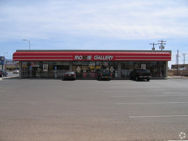
Property Detail
111 N White Sands Blvd
R021884
SUBD: CHIHUAHUA ADDITION REPLAT C BLK B LOT 14C BLOCK: B
Storebuilding
Otero
C-3
New Mexico
AH Areas with a 1% annual chance of shallow flooding, usually in the form of a pond, withan average depth ranging from 1 to 3 feet. These areas have a 26% chance of flooding over the life of a 30-year mortgage.
14c
2025
0.33 AC
2025
Las Cruces/Alamogordo
000100
Other Market Areas
4,500 SF
Alamogordo, NM
NEARBY LISTINGS FOR SALE OR LEASE
DEMOGRAPHICS near 111 N White Sands Blvd
1 mile
3 mile
5 mile
2025 Total Population
3,815
28,561
32,306
2030 Population
3,890
28,734
32,516
Pop Growth 2025-2030
+ 1.97%
+ 0.61%
+ 0.65%
Average Age
39
40
40
2025 Total Households
1,701
12,301
13,860
HH Growth 2025-2030
+ 1.59%
+ 0.44%
+ 0.48%
Median Household Inc
$47,960
$49,864
$52,019
Avg Household Size
2.10
2.20
2.20
2025 Avg HH Vehicles
2.00
2.00
2.00
Median Home Value
$139,970
$168,603
$175,521
Median Year Built
1967
1977
1979
Nearby Places
Map Layers
Map Styles
 Street
 Aerial
Transit
 Traffic
 Biking
Places
Listings with unknown addresses are not visible on the map
- Restaurants
- Banks
- Shops
- Fitness
- Groceries
Nearby Properties
Address
Land Use
TOTAL SIZE
Lot Size
Zoning
Address
Land Use
TOTAL SIZE
Lot Size
Zoning
252,192 SF
21.50 AC
C-3
Address
Land Use
TOTAL SIZE
Lot Size
Zoning
5,378 SF
18.65 AC
C-3
Address
Land Use
TOTAL SIZE
Lot Size
Zoning
7,534 SF
66.27 AC
R-1
Address
Land Use
TOTAL SIZE
Lot Size
Zoning
21,306 SF
8.85 AC
R-1
Address
Land Use
TOTAL SIZE
Lot Size
Zoning
33.74 AC
R-1
Address
Land Use
TOTAL SIZE
Lot Size
Zoning
366,561 SF
16.31 AC
C-3
Address
Land Use
TOTAL SIZE
Lot Size
Zoning
76,539 SF
8.24 AC
R-1
Address
Land Use
TOTAL SIZE
Lot Size
Zoning
211,757 SF
4.86 AC
Address
Land Use
TOTAL SIZE
Lot Size
Zoning
22,893 SF
2.18 AC
C-3
Address
Land Use
TOTAL SIZE
Lot Size
Zoning
56,121 SF
1.81 AC
C-3
Address
Land Use
TOTAL SIZE
Lot Size
Zoning
6,928 SF
30.66 AC
R-1
Address
Land Use
TOTAL SIZE
Lot Size
Zoning
102,439 SF
12.52 AC
R-2
Address
Land Use
TOTAL SIZE
Lot Size
Zoning
53,799 SF
3.97 AC
C-3
Address
Land Use
TOTAL SIZE
Lot Size
Zoning
42,104 SF
6.70 AC
C-3
Address
Land Use
TOTAL SIZE
Lot Size
Zoning
32,430 SF
1.81 AC
C-3
Address
Land Use
TOTAL SIZE
Lot Size
Zoning
39,856 SF
1.97 AC
C-3
Address
Land Use
TOTAL SIZE
Lot Size
Zoning
2,440 SF
22.25 AC
M-2
Address
Land Use
TOTAL SIZE
Lot Size
Zoning
20,889 SF
3.12 AC
C-3
Address
Land Use
TOTAL SIZE
Lot Size
Zoning
40,607 SF
3.06 AC
M-2
Address
Land Use
TOTAL SIZE
Lot Size
Zoning
45,123 SF
2.03 AC
C-3
Address
Land Use
TOTAL SIZE
Lot Size
Zoning
54,880 SF
5.17 AC
C-3
Address
Land Use
TOTAL SIZE
Lot Size
Zoning
2,304 SF
4.19 AC
C-3
Address
Land Use
TOTAL SIZE
Lot Size
Zoning
46,761 SF
2.42 AC
C-3
Address
Land Use
TOTAL SIZE
Lot Size
Zoning
56,021 SF
4.80 AC
C-3
Address
Land Use
TOTAL SIZE
Lot Size
Zoning
126,688 SF
19.62 AC
R-1
Address
Land Use
TOTAL SIZE
Lot Size
Zoning
1,064 SF
15.91 AC
Address
Land Use
TOTAL SIZE
Lot Size
Zoning
11,240 SF
125.04 AC
R-1
Address
Land Use
TOTAL SIZE
Lot Size
Zoning
4,768 SF
4 AC
R-1
Address
Land Use
TOTAL SIZE
Lot Size
Zoning
26,933 SF
3.52 AC
C-3
Address
Land Use
TOTAL SIZE
Lot Size
Zoning
26,215 SF
5.04 AC
C-3
The World's #1 Commercial Real Estate Marketplace
Connect with us
© 2026 CoStar Group
The information above has been obtained from sources believed reliable. While we do not doubt its accuracy we have not verified it and make no guarantee, warranty or representation about it. It is your responsibility to independently confirm its accuracy and completeness. Any projections, opinions, assumptions, or estimates used are for example only and do not represent the current or future performance of the property. The value of this transaction to you depends on tax and other factors which should be evaluated by your tax, financial, and legal advisors. You and your advisors should conduct a careful, independent investigation of the property to determine to your satisfaction the suitability of the property for your needs.