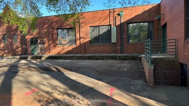
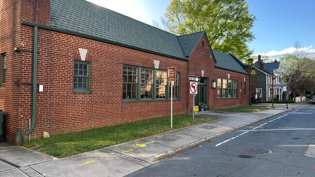
Property Record
111 W Bank St, Salisbury, NC 28144

Property Detail
111 W Bank St
010-1600
1429 796
Warehouse
Rowan
B and X Area of moderate flood hazard, usually the area between the limits of the 100-year and 500-year floods.
North Carolina
2025
0.39 AC
2025
Rowan County
052000
Charlotte
12,588 SF
Charlotte-Concord-Gastonia, NC-SC
NEARBY LISTINGS FOR SALE OR LEASE
DEMOGRAPHICS near 111 W Bank St
1 mile
3 mile
5 mile
2025 Total Population
8,790
35,384
59,324
2030 Population
9,250
37,018
61,922
Pop Growth 2025-2030
+ 5.23%
+ 4.62%
+ 4.38%
Average Age
38
40
41
2025 Total Households
3,527
14,130
23,429
HH Growth 2025-2030
+ 5.61%
+ 4.92%
+ 4.61%
Median Household Inc
$38,880
$56,905
$58,231
Avg Household Size
2.20
2.30
2.30
2025 Avg HH Vehicles
1.00
2.00
2.00
Median Home Value
$236,978
$247,764
$257,769
Median Year Built
1956
1972
1978
Nearby Places
Map Layers
Map Styles
 Street
 Aerial
Layers
 Traffic
 Biking
Places
Listings with unknown addresses are not visible on the map
- Restaurants
- Banks
- Shops
- Fitness
- Groceries
PUBLIC TRANSPORTATION
TRANSIT/SUBWAY
Salisbury Station (Piedmont - North Carolina by Train (NC Train))
Drive
Walk
Distance
Salisbury Station (Piedmont - North Carolina by Train (NC Train))
3 min
8 min
0.4 mi
COMMUTER RAIL
Salisbury Station (Piedmont - North Carolina by Train (NC Train))
Drive
Walk
Distance
Salisbury Station (Piedmont - North Carolina by Train (NC Train))
3 min
8 min
0.4 mi
AIRPORT
Concord-Padgett Regional
Drive
Walk
Distance
Concord-Padgett Regional
40 min
28.8 mi
SALE & LEASE HISTORY
LISTING DATE
SALE/LEASE

Sep 25, 2016
For Lease
Sep 24, 2016
For Sale
Apr 10, 2024
For Lease
Nearby Properties
Address
Land Use
TOTAL SIZE
Lot Size
Zoning
Address
Land Use
TOTAL SIZE
Lot Size
Zoning
221,875 SF
7.31 AC
Address
Land Use
TOTAL SIZE
Lot Size
Zoning
193,040 SF
73.85 AC
Address
Land Use
TOTAL SIZE
Lot Size
Zoning
116,333 SF
30.31 AC
Address
Land Use
TOTAL SIZE
Lot Size
Zoning
61,191 SF
33.96 AC
Address
Land Use
TOTAL SIZE
Lot Size
Zoning
165,360 SF
76.51 AC
Address
Land Use
TOTAL SIZE
Lot Size
Zoning
41,142 SF
16.18 AC
Address
Land Use
TOTAL SIZE
Lot Size
Zoning
48,865 SF
55.30 AC
HB:HIGHWAY
Address
Land Use
TOTAL SIZE
Lot Size
Zoning
27,321 SF
11.66 AC
Address
Land Use
TOTAL SIZE
Lot Size
Zoning
99,416 SF
31.69 AC
Address
Land Use
TOTAL SIZE
Lot Size
Zoning
144,720 SF
14.53 AC
Address
Land Use
TOTAL SIZE
Lot Size
Zoning
27,932 SF
108.40 AC
Address
Land Use
TOTAL SIZE
Lot Size
Zoning
59,528 SF
25.35 AC
Address
Land Use
TOTAL SIZE
Lot Size
Zoning
206,758 SF
24.40 AC
Address
Land Use
TOTAL SIZE
Lot Size
Zoning
37,281 SF
10 AC
Address
Land Use
TOTAL SIZE
Lot Size
Zoning
12,960 SF
22.04 AC
Address
Land Use
TOTAL SIZE
Lot Size
Zoning
56,676 SF
2.73 AC
HB:HIGHWAY
Address
Land Use
TOTAL SIZE
Lot Size
Zoning
86,517 SF
14 AC
Address
Land Use
TOTAL SIZE
Lot Size
Zoning
25,068 SF
7.18 AC
HB:HIGHWAY
Address
Land Use
TOTAL SIZE
Lot Size
Zoning
59,092 SF
1.73 AC
Address
Land Use
TOTAL SIZE
Lot Size
Zoning
31,327 SF
1.86 AC
Address
Land Use
TOTAL SIZE
Lot Size
Zoning
69,072 SF
11.32 AC
HB:HIGHWAY
Address
Land Use
TOTAL SIZE
Lot Size
Zoning
141,593 SF
34.61 AC
HB:HIGHWAY
Address
Land Use
TOTAL SIZE
Lot Size
Zoning
19,626 SF
2.29 AC
HB:HIGHWAY
Address
Land Use
TOTAL SIZE
Lot Size
Zoning
71,353 SF
37.10 AC
Address
Land Use
TOTAL SIZE
Lot Size
Zoning
63,227 SF
9.23 AC
HB:HIGHWAY
Address
Land Use
TOTAL SIZE
Lot Size
Zoning
151.25 AC
Address
Land Use
TOTAL SIZE
Lot Size
Zoning
81,700 SF
9.67 AC
HB:HIGHWAY
Address
Land Use
TOTAL SIZE
Lot Size
Zoning
37,692 SF
2.80 AC
Address
Land Use
TOTAL SIZE
Lot Size
Zoning
23,526 SF
9.36 AC
Address
Land Use
TOTAL SIZE
Lot Size
Zoning
18,200 SF
2.94 AC
The World's #1 Commercial Real Estate Marketplace
Connect with us
© 2026 CoStar Group
The information above has been obtained from sources believed reliable. While we do not doubt its accuracy we have not verified it and make no guarantee, warranty or representation about it. It is your responsibility to independently confirm its accuracy and completeness. Any projections, opinions, assumptions, or estimates used are for example only and do not represent the current or future performance of the property. The value of this transaction to you depends on tax and other factors which should be evaluated by your tax, financial, and legal advisors. You and your advisors should conduct a careful, independent investigation of the property to determine to your satisfaction the suitability of the property for your needs.