Property Record
1110 Performance Dr, Stockton, CA 95206
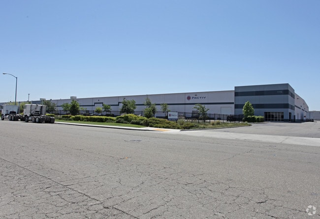


Property Detail
1110 Performance Dr
177-450-13
REDRAWN NOV-04-2008 FROM ORIGINAL APN 177-340-81
Lightindustrial
San Joaquin
A Areas with a 1% annual chance of flooding and a 26% chance of flooding over the life of a 30-year mortgage.
California
2025
20.42 AC
2025
SE Stockton
003803
Stockton/Modesto
452,000 SF
Stockton-Lodi, CA
NEARBY LISTINGS FOR SALE OR LEASE
DEMOGRAPHICS near 1110 Performance Dr
1 mile
3 mile
5 mile
2025 Total Population
243
46,581
140,073
2030 Population
246
48,351
145,661
Pop Growth 2025-2030
+ 1.23%
+ 3.80%
+ 3.99%
Average Age
37
35
36
2025 Total Households
71
11,561
37,971
HH Growth 2025-2030
+ 1.41%
+ 4.13%
+ 4.33%
Median Household Inc
$93,749
$72,622
$69,357
Avg Household Size
3.30
3.70
3.40
2025 Avg HH Vehicles
2.00
2.00
2.00
Median Home Value
$428,571
$413,119
$429,934
Median Year Built
1965
1991
1984
Nearby Places
Map Layers
Map Styles
 Street
 Aerial
Layers
 Traffic
 Biking
Places
Listings with unknown addresses are not visible on the map
- Restaurants
- Banks
- Shops
- Fitness
- Groceries
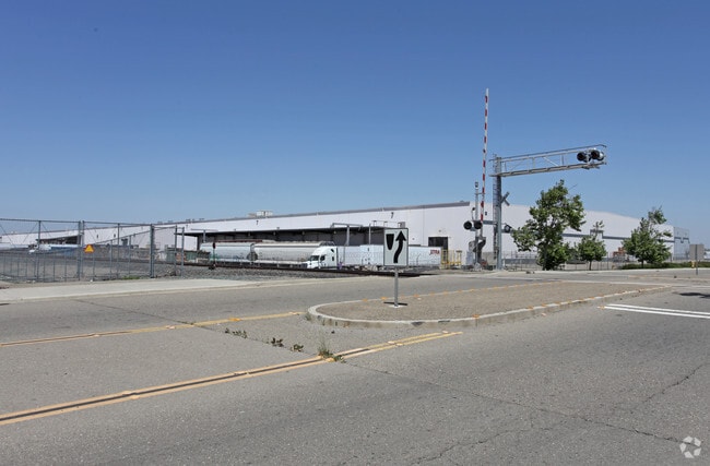
PUBLIC TRANSPORTATION
COMMUTER RAIL
Stockton- Robert J Cabral Station (ACE Train - Altamont Corridor Express)
Drive
Walk
Distance
Stockton- Robert J Cabral Station (ACE Train - Altamont Corridor Express)
11 min
5.2 mi
Stockton (San Joaquins - Amtrak)
Drive
Walk
Distance
Stockton (San Joaquins - Amtrak)
11 min
5.3 mi
AIRPORT
Stockton Metro
Drive
Walk
Distance
Stockton Metro
5 min
1.1 mi
Freight Ports
Port of Stockton
Drive
Walk
Distance
Port of Stockton
14 min
7.7 mi
Nearby Properties
Address
Land Use
TOTAL SIZE
Lot Size
Zoning
Address
Land Use
TOTAL SIZE
Lot Size
Zoning
57.72 AC
Address
Land Use
TOTAL SIZE
Lot Size
Zoning
240,210 SF
66.15 AC
Address
Land Use
TOTAL SIZE
Lot Size
Zoning
615,440 SF
76.23 AC
IG
Address
Land Use
TOTAL SIZE
Lot Size
Zoning
39.06 AC
Address
Land Use
TOTAL SIZE
Lot Size
Zoning
830,175 SF
46.57 AC
IG
Address
Land Use
TOTAL SIZE
Lot Size
Zoning
824,735 SF
52.87 AC
Address
Land Use
TOTAL SIZE
Lot Size
Zoning
326,934 SF
56.52 AC
IG
Address
Land Use
TOTAL SIZE
Lot Size
Zoning
545,832 SF
29.07 AC
Address
Land Use
TOTAL SIZE
Lot Size
Zoning
574,560 SF
32.34 AC
Address
Land Use
TOTAL SIZE
Lot Size
Zoning
419,608 SF
23.01 AC
IG
Address
Land Use
TOTAL SIZE
Lot Size
Zoning
511,718 SF
21.18 AC
Address
Land Use
TOTAL SIZE
Lot Size
Zoning
508,800 SF
24 AC
Address
Land Use
TOTAL SIZE
Lot Size
Zoning
434,900 SF
17.05 AC
Address
Land Use
TOTAL SIZE
Lot Size
Zoning
512,000 SF
20.16 AC
Address
Land Use
TOTAL SIZE
Lot Size
Zoning
521,500 SF
12.06 AC
Address
Land Use
TOTAL SIZE
Lot Size
Zoning
513,778 SF
11.88 AC
Address
Land Use
TOTAL SIZE
Lot Size
Zoning
69,954 SF
24.92 AC
Address
Land Use
TOTAL SIZE
Lot Size
Zoning
586,610 SF
27.36 AC
Address
Land Use
TOTAL SIZE
Lot Size
Zoning
522,400 SF
23.72 AC
Address
Land Use
TOTAL SIZE
Lot Size
Zoning
350,892 SF
20.34 AC
Address
Land Use
TOTAL SIZE
Lot Size
Zoning
42,267 SF
10.53 AC
Address
Land Use
TOTAL SIZE
Lot Size
Zoning
443,640 SF
24.30 AC
Address
Land Use
TOTAL SIZE
Lot Size
Zoning
178,761 SF
11.43 AC
Address
Land Use
TOTAL SIZE
Lot Size
Zoning
164,000 SF
7.62 AC
Address
Land Use
TOTAL SIZE
Lot Size
Zoning
1,568 SF
129.97 AC
IG
Address
Land Use
TOTAL SIZE
Lot Size
Zoning
223,470 SF
21.05 AC
Address
Land Use
TOTAL SIZE
Lot Size
Zoning
295,680 SF
37.65 AC
Address
Land Use
TOTAL SIZE
Lot Size
Zoning
500,000 SF
28.38 AC
The World's #1 Commercial Real Estate Marketplace
Connect with us
© 2026 CoStar Group
The information above has been obtained from sources believed reliable. While we do not doubt its accuracy we have not verified it and make no guarantee, warranty or representation about it. It is your responsibility to independently confirm its accuracy and completeness. Any projections, opinions, assumptions, or estimates used are for example only and do not represent the current or future performance of the property. The value of this transaction to you depends on tax and other factors which should be evaluated by your tax, financial, and legal advisors. You and your advisors should conduct a careful, independent investigation of the property to determine to your satisfaction the suitability of the property for your needs.