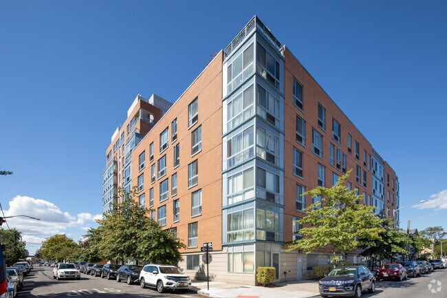
Property Record
1115 Banner Ave, Brooklyn, NY 11235


NEARBY LISTINGS FOR SALE OR LEASE
Property Detail
1115 Banner Ave
08763-0007
ID2005112700095013
Cooperative
Kings
AE
New York
3604970354F
13
2024
0.51 AC
2025
Brighton Beach
060800
Long Island (New York)
56,652 SF
New York-Jersey City-White Plains, NY-NJ
DEMOGRAPHICS near 1115 Banner Ave
1 mile
3 mile
5 mile
2024 Total Population
110,858
517,165
1,172,129
2029 Population
103,911
483,215
1,088,249
Pop Growth 2024-2029
(6.27%)
(6.56%)
(7.16%)
Average Age
45
42
40
2024 Total Households
44,976
185,477
404,470
HH Growth 2024-2029
(6.49%)
(6.92%)
(7.44%)
Median Household Inc
$58,338
$60,666
$65,049
Avg Household Size
2.40
2.70
2.80
2024 Avg HH Vehicles
1.00
1.00
1.00
Median Home Value
$667,838
$758,820
$777,147
Median Year Built
1956
1949
1948
Nearby Places
Map Layers
Map Styles
 Street
 Aerial
Transit
 Traffic
 Biking
Places
Listings with unknown addresses are not visible on the map
- Restaurants
- Banks
- Shops
- Fitness
- Groceries
PUBLIC TRANSPORTATION
TRANSIT/SUBWAY
Sheepshead Bay (B - New York MTA Subway (The Subway), Q - New York MTA Subway (The Subway))
Drive
Walk
Distance
Sheepshead Bay (B - New York MTA Subway (The Subway), Q - New York MTA Subway (The Subway))
3 min
11 min
0.6 mi
Brighton Beach (B - New York MTA Subway (The Subway), Q - New York MTA Subway (The Subway))
Drive
Walk
Distance
Brighton Beach (B - New York MTA Subway (The Subway), Q - New York MTA Subway (The Subway))
2 min
12 min
0.6 mi
Ocean Parkway (Q - New York MTA Subway (The Subway))
Drive
Walk
Distance
Ocean Parkway (Q - New York MTA Subway (The Subway))
3 min
19 min
1.0 mi
Neptune Avenue (F - New York MTA Subway (The Subway))
Drive
Walk
Distance
Neptune Avenue (F - New York MTA Subway (The Subway))
3 min
20 min
1.0 mi
COMMUTER RAIL
Nostrand Avenue Station (Far Rockaway Branch - Long Island Rail Road, Hempstead Branch - Long Island Rail Road, Long Beach Branch - Long Island Rail Road, West Hempstead Branch - Long Island Rail Road)
Drive
Walk
Distance
Nostrand Avenue Station (Far Rockaway Branch - Long Island Rail Road, Hempstead Branch - Long Island Rail Road, Long Beach Branch - Long Island Rail Road, West Hempstead Branch - Long Island Rail Road)
19 min
8.0 mi
Grasmere (Staten Island Railway - New York MTA Subway (The Subway))
Drive
Walk
Distance
Grasmere (Staten Island Railway - New York MTA Subway (The Subway))
17 min
9.0 mi
AIRPORT
John F Kennedy International
Drive
Walk
Distance
John F Kennedy International
25 min
14.6 mi
LaGuardia
Drive
Walk
Distance
LaGuardia
35 min
21.6 mi
Newark Liberty International
Drive
Walk
Distance
Newark Liberty International
38 min
24.2 mi
Freight Ports
NY - Red Hook Container Terminal
Drive
Walk
Distance
NY - Red Hook Container Terminal
17 min
8.4 mi
Nearby Properties
Address
Land Use
TOTAL SIZE
Lot Size
Zoning
Address
Land Use
TOTAL SIZE
Lot Size
Zoning
200 SF
281.30 AC
R4
Address
Land Use
TOTAL SIZE
Lot Size
Zoning
200 SF
281.30 AC
R4
Address
Land Use
TOTAL SIZE
Lot Size
Zoning
200 SF
281.30 AC
R4
Address
Land Use
TOTAL SIZE
Lot Size
Zoning
200 SF
281.30 AC
R4
Address
Land Use
TOTAL SIZE
Lot Size
Zoning
200 SF
281.30 AC
R4
Address
Land Use
TOTAL SIZE
Lot Size
Zoning
200 SF
281.30 AC
R4
Address
Land Use
TOTAL SIZE
Lot Size
Zoning
200 SF
281.30 AC
R4
Address
Land Use
TOTAL SIZE
Lot Size
Zoning
200 SF
281.30 AC
R4
Address
Land Use
TOTAL SIZE
Lot Size
Zoning
200 SF
281.30 AC
R4
Address
Land Use
TOTAL SIZE
Lot Size
Zoning
200 SF
281.30 AC
R4
Address
Land Use
TOTAL SIZE
Lot Size
Zoning
200 SF
281.30 AC
R4
Address
Land Use
TOTAL SIZE
Lot Size
Zoning
200 SF
281.30 AC
R4
Address
Land Use
TOTAL SIZE
Lot Size
Zoning
200 SF
281.30 AC
R4
Address
Land Use
TOTAL SIZE
Lot Size
Zoning
200 SF
281.30 AC
R4
Address
Land Use
TOTAL SIZE
Lot Size
Zoning
200 SF
281.30 AC
R4
Address
Land Use
TOTAL SIZE
Lot Size
Zoning
200 SF
281.30 AC
R4
Address
Land Use
TOTAL SIZE
Lot Size
Zoning
200 SF
281.30 AC
R4
Address
Land Use
TOTAL SIZE
Lot Size
Zoning
200 SF
281.30 AC
R4
Address
Land Use
TOTAL SIZE
Lot Size
Zoning
200 SF
281.30 AC
R4
Address
Land Use
TOTAL SIZE
Lot Size
Zoning
200 SF
281.30 AC
R4
Address
Land Use
TOTAL SIZE
Lot Size
Zoning
200 SF
281.30 AC
R4
Address
Land Use
TOTAL SIZE
Lot Size
Zoning
200 SF
281.30 AC
R4
Address
Land Use
TOTAL SIZE
Lot Size
Zoning
200 SF
281.30 AC
R4
Address
Land Use
TOTAL SIZE
Lot Size
Zoning
200 SF
281.30 AC
R4
Address
Land Use
TOTAL SIZE
Lot Size
Zoning
200 SF
281.30 AC
R4
Address
Land Use
TOTAL SIZE
Lot Size
Zoning
200 SF
281.30 AC
R4
Address
Land Use
TOTAL SIZE
Lot Size
Zoning
200 SF
281.30 AC
R4
Address
Land Use
TOTAL SIZE
Lot Size
Zoning
200 SF
281.30 AC
R4
Address
Land Use
TOTAL SIZE
Lot Size
Zoning
200 SF
281.30 AC
R4
Address
Land Use
TOTAL SIZE
Lot Size
Zoning
200 SF
281.30 AC
R4
The World's #1 Commercial Real Estate Marketplace
Connect with us
© 2026 CoStar Group
The information above has been obtained from sources believed reliable. While we do not doubt its accuracy we have not verified it and make no guarantee, warranty or representation about it. It is your responsibility to independently confirm its accuracy and completeness. Any projections, opinions, assumptions, or estimates used are for example only and do not represent the current or future performance of the property. The value of this transaction to you depends on tax and other factors which should be evaluated by your tax, financial, and legal advisors. You and your advisors should conduct a careful, independent investigation of the property to determine to your satisfaction the suitability of the property for your needs.