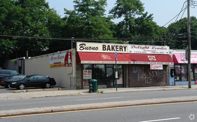
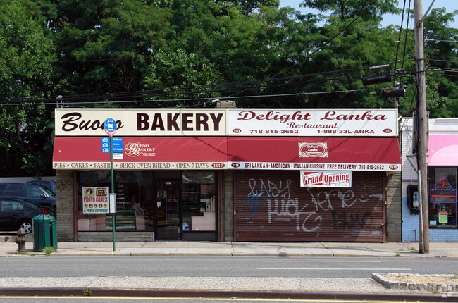
Property Record
1115 Hylan Blvd, Staten Island, NY 10305
NEARBY LISTINGS FOR SALE OR LEASE
Property Detail
1115 Hylan Blvd
New York-Jersey City-White Plains, NY-NJ
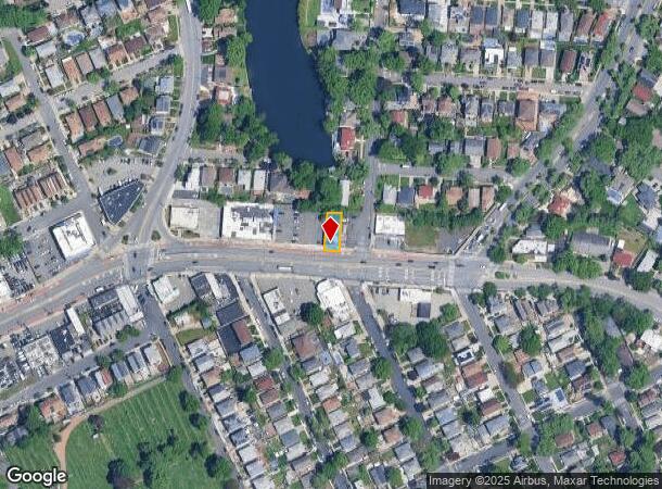
Cameron Park Map
03227-0003
PRIOR REF 121243 04/14/2006; SOME INFO KEYED FROM LEGAL DESCRIPTION, BUT COMPLETE LEGAL NOT CAPTURED
Storebuilding
Staten Island
X
New York
3604970327F
3
2024
0.09 AC
2025
Staten Island
006400
Long Island (New York)
2,520 SF
DEMOGRAPHICS near 1115 Hylan Blvd
1 Mile
3 Mile
5 Mile
2024 Total Population
44,224
214,696
728,244
2029 Population
43,740
211,790
693,074
Pop Growth 2024-2029
(1.09%)
(1.35%)
(4.83%)
Average Age
42
41
41
2024 Total Households
15,263
77,944
252,802
HH Growth 2024-2029
(1.15%)
(1.58%)
(4.94%)
Median Household Inc
$76,919
$80,886
$71,581
Avg Household Size
2.80
2.60
2.80
2024 Avg HH Vehicles
1.00
1.00
1.00
Median Home Value
$656,271
$669,583
$687,498
Median Year Built
1972
1963
1955
Nearby Places
- Restaurants
- Banks
- Shops
- Fitness
- Groceries
PUBLIC TRANSPORTATION
COMMUTER RAIL
Grasmere (Staten Island Railway - New York MTA Subway (The Subway))
DRIVE
WALK
Distance
Grasmere (Staten Island Railway - New York MTA Subway (The Subway))
1 min
9 min
0.5 mi
Old Town (Staten Island Railway - New York MTA Subway (The Subway))
DRIVE
WALK
Distance
Old Town (Staten Island Railway - New York MTA Subway (The Subway))
1 min
10 min
0.5 mi
AIRPORT
Newark Liberty International
DRIVE
WALK
Distance
Newark Liberty International
26 min
16.3 mi
LaGuardia
DRIVE
WALK
Distance
LaGuardia
35 min
20.7 mi
John F Kennedy International
DRIVE
WALK
Distance
John F Kennedy International
35 min
23.4 mi
Freight Ports
GCT Bayonne
DRIVE
WALK
Distance
GCT Bayonne
23 min
12.1 mi
Nearby Properties
Address
Land Use
TOTAL SIZE
Lot Size
Zoning
Address
Land Use
TOTAL SIZE
Lot Size
Zoning
1,524,659 SF
170.96 AC
R4
Address
Land Use
TOTAL SIZE
Lot Size
Zoning
686,130 SF
189.62 AC
R3-2
Address
Land Use
TOTAL SIZE
Lot Size
Zoning
640,077 SF
19.34 AC
R3-1
Address
Land Use
TOTAL SIZE
Lot Size
Zoning
135,000 SF
117.71 AC
PARK
Address
Land Use
TOTAL SIZE
Lot Size
Zoning
236,591 SF
207.66 AC
R3-2
Address
Land Use
TOTAL SIZE
Lot Size
Zoning
310,560 SF
15.90 AC
C4-1
Address
Land Use
TOTAL SIZE
Lot Size
Zoning
538,240 SF
12.08 AC
R2
Address
Land Use
TOTAL SIZE
Lot Size
Zoning
494,840 SF
34.77 AC
R3-2
Address
Land Use
TOTAL SIZE
Lot Size
Zoning
286,000 SF
12.63 AC
PARK
Address
Land Use
TOTAL SIZE
Lot Size
Zoning
521,405 SF
52.79 AC
R3-1
Address
Land Use
TOTAL SIZE
Lot Size
Zoning
421,275 SF
18.95 AC
R3-2
Address
Land Use
TOTAL SIZE
Lot Size
Zoning
111,000 SF
186.03 AC
PARK
Address
Land Use
TOTAL SIZE
Lot Size
Zoning
183,215 SF
3.47 AC
C4-2
Address
Land Use
TOTAL SIZE
Lot Size
Zoning
240 SF
47.41 AC
R3-2
Address
Land Use
TOTAL SIZE
Lot Size
Zoning
476,145 SF
50.97 AC
R3-1
Address
Land Use
TOTAL SIZE
Lot Size
Zoning
43,068 SF
216.83 AC
PARK
Address
Land Use
TOTAL SIZE
Lot Size
Zoning
146,855 SF
16.50 AC
R3-1
Address
Land Use
TOTAL SIZE
Lot Size
Zoning
414,400 SF
2.70 AC
R7A
Address
Land Use
TOTAL SIZE
Lot Size
Zoning
77,502 SF
1.29 AC
R3-1
Address
Land Use
TOTAL SIZE
Lot Size
Zoning
900 SF
50 AC
R1-1
Address
Land Use
TOTAL SIZE
Lot Size
Zoning
294,125 SF
2.43 AC
R3A
Address
Land Use
TOTAL SIZE
Lot Size
Zoning
654,030 SF
13.94 AC
R5
Address
Land Use
TOTAL SIZE
Lot Size
Zoning
330,780 SF
676.51 AC
C4-2A
Address
Land Use
TOTAL SIZE
Lot Size
Zoning
151,637 SF
7.41 AC
C4-1
Address
Land Use
TOTAL SIZE
Lot Size
Zoning
45,570 SF
206.38 AC
PARKUS
Address
Land Use
TOTAL SIZE
Lot Size
Zoning
7,410 SF
44.60 AC
R1-1
Address
Land Use
TOTAL SIZE
Lot Size
Zoning
151,080 SF
17.59 AC
R1-2
Address
Land Use
TOTAL SIZE
Lot Size
Zoning
348,000 SF
1.37 AC
R5
Address
Land Use
TOTAL SIZE
Lot Size
Zoning
37.30 AC
PARK
Address
Land Use
TOTAL SIZE
Lot Size
Zoning
19,102 SF
67.84 AC
PARK
The World's #1 Commercial Real Estate Marketplace
Connect with us
© 2025 CoStar Group
The information above has been obtained from sources believed reliable. While we do not doubt its accuracy we have not verified it and make no guarantee, warranty or representation about it. It is your responsibility to independently confirm its accuracy and completeness. Any projections, opinions, assumptions, or estimates used are for example only and do not represent the current or future performance of the property. The value of this transaction to you depends on tax and other factors which should be evaluated by your tax, financial, and legal advisors. You and your advisors should conduct a careful, independent investigation of the property to determine to your satisfaction the suitability of the property for your needs.