Property Record
1115 Trinity Ln, Ashland, KY 41102
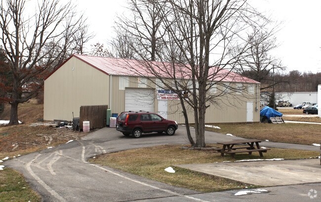


Property Detail
1115 Trinity Ln
024-07-00-008.00
TRINITY LANE
Communitycenter
BOYD
Z03
Kentucky
B and X Area of moderate flood hazard, usually the area between the limits of the 100-year and 500-year floods.
2.19 AC
2025
Outlying Boyd County
2025
Huntington/Ashland
031003
Huntington-Ashland, WV-KY-OH
1,120 SF
NEARBY LISTINGS FOR SALE OR LEASE
DEMOGRAPHICS near 1115 Trinity Ln
1 mile
3 mile
5 mile
2025 Total Population
3,479
12,040
38,235
2030 Population
3,459
11,944
37,798
Pop Growth 2025-2030
(0.57%)
(0.80%)
(1.14%)
Average Age
45
44
42
2025 Total Households
843
4,201
15,063
HH Growth 2025-2030
(0.95%)
(0.93%)
(1.18%)
Median Household Inc
$74,923
$71,278
$62,593
Avg Household Size
2.50
2.40
2.40
2025 Avg HH Vehicles
2.00
2.00
2.00
Median Home Value
$164,780
$163,523
$146,743
Median Year Built
1979
1975
1970
Nearby Places
Map Layers
Map Styles
 Street
 Aerial
Transit
 Traffic
 Biking
Places
Listings with unknown addresses are not visible on the map
- Restaurants
- Banks
- Shops
- Fitness
- Groceries
PUBLIC TRANSPORTATION
COMMUTER RAIL
Ashland Amtrak Station (Cardinal - Amtrak)
Drive
Walk
Distance
Ashland Amtrak Station (Cardinal - Amtrak)
10 min
5.9 mi
AIRPORT
Tri-State/Milton J Ferguson Field
Drive
Walk
Distance
Tri-State/Milton J Ferguson Field
24 min
13.3 mi
Freight Ports
Port of Toledo
Drive
Walk
Distance
Port of Toledo
341 min
262.9 mi
Nearby Properties
Address
Land Use
TOTAL SIZE
Lot Size
Zoning
Address
Land Use
TOTAL SIZE
Lot Size
Zoning
0.52 AC
Address
Land Use
TOTAL SIZE
Lot Size
Zoning
87.12 AC
COMMERCIAL
Address
Land Use
TOTAL SIZE
Lot Size
Zoning
149,000 SF
0.18 AC
COMMERCIAL
Address
Land Use
TOTAL SIZE
Lot Size
Zoning
72.48 AC
COMMERCIAL
Address
Land Use
TOTAL SIZE
Lot Size
Zoning
11 AC
COMMERCIAL
Address
Land Use
TOTAL SIZE
Lot Size
Zoning
22 AC
OTHER
Address
Land Use
TOTAL SIZE
Lot Size
Zoning
22,592 SF
43.50 AC
OTHER
Address
Land Use
TOTAL SIZE
Lot Size
Zoning
33,980 SF
2.03 AC
COMMERCIAL
Address
Land Use
TOTAL SIZE
Lot Size
Zoning
31,220 SF
1.78 AC
COMMERCIAL
Address
Land Use
TOTAL SIZE
Lot Size
Zoning
Address
Land Use
TOTAL SIZE
Lot Size
Zoning
Address
Land Use
TOTAL SIZE
Lot Size
Zoning
1.04 AC
COMMERCIAL
Address
Land Use
TOTAL SIZE
Lot Size
Zoning
6.72 AC
Address
Land Use
TOTAL SIZE
Lot Size
Zoning
25,524 SF
2 AC
Address
Land Use
TOTAL SIZE
Lot Size
Zoning
6,840 SF
24 AC
COMMERCIAL
Address
Land Use
TOTAL SIZE
Lot Size
Zoning
1.02 AC
COMMERCIAL
Address
Land Use
TOTAL SIZE
Lot Size
Zoning
9.03 AC
Z02
Address
Land Use
TOTAL SIZE
Lot Size
Zoning
Address
Land Use
TOTAL SIZE
Lot Size
Zoning
2.44 AC
COMMERCIAL
Address
Land Use
TOTAL SIZE
Lot Size
Zoning
1.09 AC
COMMERCIAL
Address
Land Use
TOTAL SIZE
Lot Size
Zoning
1.10 AC
Address
Land Use
TOTAL SIZE
Lot Size
Zoning
1.11 AC
COMMERCIAL
Address
Land Use
TOTAL SIZE
Lot Size
Zoning
28,239 SF
2.17 AC
Address
Land Use
TOTAL SIZE
Lot Size
Zoning
19,488 SF
0.28 AC
COMMERCIAL
Address
Land Use
TOTAL SIZE
Lot Size
Zoning
12.86 AC
Z02
Address
Land Use
TOTAL SIZE
Lot Size
Zoning
1 AC
Z02
Address
Land Use
TOTAL SIZE
Lot Size
Zoning
0.11 AC
COMMERCIAL
Address
Land Use
TOTAL SIZE
Lot Size
Zoning
1.29 AC
Address
Land Use
TOTAL SIZE
Lot Size
Zoning
52.68 AC
Address
Land Use
TOTAL SIZE
Lot Size
Zoning
5,580 SF
1.06 AC
Z02
The World's #1 Commercial Real Estate Marketplace
Connect with us
© 2026 CoStar Group
The information above has been obtained from sources believed reliable. While we do not doubt its accuracy we have not verified it and make no guarantee, warranty or representation about it. It is your responsibility to independently confirm its accuracy and completeness. Any projections, opinions, assumptions, or estimates used are for example only and do not represent the current or future performance of the property. The value of this transaction to you depends on tax and other factors which should be evaluated by your tax, financial, and legal advisors. You and your advisors should conduct a careful, independent investigation of the property to determine to your satisfaction the suitability of the property for your needs.