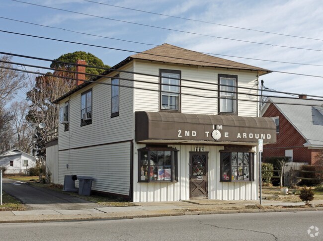
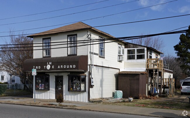
Property Record
112 Buckroe Ave, Hampton, VA 23664

Property Detail
112 Buckroe Ave
12006747
BUCKROE BCH& CHES LD CO L4. B7
Officebuilding
Hampton City
9 R-M MULT
Virginia
C and X Area of minimal flood hazard, usually depicted on FIRMs as above the 500-year flood level.
4
2025
0.16 AC
2025
Fox Hill
011001
Hampton Roads
1,888 SF
Virginia Beach-Chesapeake-Norfolk, VA-NC
NEARBY LISTINGS FOR SALE OR LEASE
DEMOGRAPHICS near 112 Buckroe Ave
1 mile
3 mile
5 mile
2024 Total Population
6,867
44,555
75,983
2029 Population
6,909
44,348
76,138
Pop Growth 2024-2029
+ 0.61%
(0.46%)
+ 0.20%
Average Age
42
40
39
2024 Total Households
3,005
17,845
31,035
HH Growth 2024-2029
+ 0.73%
(0.15%)
+ 0.34%
Median Household Inc
$70,746
$77,601
$72,549
Avg Household Size
2.20
2.30
2.30
2024 Avg HH Vehicles
2.00
2.00
2.00
Median Home Value
$267,963
$256,476
$250,172
Median Year Built
1975
1971
1971
Nearby Places
Map Layers
Map Styles
 Street
 Aerial
Transit
 Traffic
 Biking
Places
Listings with unknown addresses are not visible on the map
- Restaurants
- Banks
- Shops
- Fitness
- Groceries
PUBLIC TRANSPORTATION
AIRPORT
Norfolk International
Drive
Walk
Distance
Norfolk International
28 min
16.5 mi
Newport News/Williamsburg International
Drive
Walk
Distance
Newport News/Williamsburg International
28 min
17.0 mi
Freight Ports
Virginia Port Authority - Newport News
Drive
Walk
Distance
Virginia Port Authority - Newport News
19 min
11.0 mi
Nearby Properties
Address
Land Use
TOTAL SIZE
Lot Size
Zoning
Address
Land Use
TOTAL SIZE
Lot Size
Zoning
1 SF
92.67 AC
5 R-13 ONE
Address
Land Use
TOTAL SIZE
Lot Size
Zoning
83.50 AC
5 R-13 ONE
Address
Land Use
TOTAL SIZE
Lot Size
Zoning
7,644 SF
322.21 AC
19 PO-1 GE
Address
Land Use
TOTAL SIZE
Lot Size
Zoning
204,584 SF
34.79 AC
6 R-11 ONE
Address
Land Use
TOTAL SIZE
Lot Size
Zoning
240,000 SF
30.38 AC
7 R-9 ONE
Address
Land Use
TOTAL SIZE
Lot Size
Zoning
4.99 AC
47 PH-2 PH
Address
Land Use
TOTAL SIZE
Lot Size
Zoning
140,649 SF
25.29 AC
7 R-9 ONE
Address
Land Use
TOTAL SIZE
Lot Size
Zoning
253,896 SF
13.32 AC
9 R-M MULT
Address
Land Use
TOTAL SIZE
Lot Size
Zoning
123,151 SF
21.81 AC
5 R-13 ONE
Address
Land Use
TOTAL SIZE
Lot Size
Zoning
127,600 SF
27.95 AC
5 R-13 ONE
Address
Land Use
TOTAL SIZE
Lot Size
Zoning
27,710 SF
14.38 AC
0 MD-2 MUL
Address
Land Use
TOTAL SIZE
Lot Size
Zoning
31,748 SF
5.30 AC
5 R-13 ONE
Address
Land Use
TOTAL SIZE
Lot Size
Zoning
11,772 SF
10.86 AC
0 MD-2 MUL
Address
Land Use
TOTAL SIZE
Lot Size
Zoning
122,256 SF
4.80 AC
11 MD-4 MU
Address
Land Use
TOTAL SIZE
Lot Size
Zoning
808 SF
112.03 AC
19 PO-1 GE
Address
Land Use
TOTAL SIZE
Lot Size
Zoning
2,204 SF
90.11 AC
19 PO-1 GE
Address
Land Use
TOTAL SIZE
Lot Size
Zoning
148,176 SF
10.20 AC
18 MD-1 TO
Address
Land Use
TOTAL SIZE
Lot Size
Zoning
203,695 SF
0.51 AC
29 DT-2 DO
Address
Land Use
TOTAL SIZE
Lot Size
Zoning
23,680 SF
4.60 AC
11 MD-4 MU
Address
Land Use
TOTAL SIZE
Lot Size
Zoning
43,404 SF
26.97 AC
13 C-1 NEI
Address
Land Use
TOTAL SIZE
Lot Size
Zoning
20,312 SF
12.36 AC
6 R-11 ONE
Address
Land Use
TOTAL SIZE
Lot Size
Zoning
7,516 SF
6 AC
0 MD-2 MUL
Address
Land Use
TOTAL SIZE
Lot Size
Zoning
25,501 SF
14.50 AC
19 PO-1 GE
Address
Land Use
TOTAL SIZE
Lot Size
Zoning
50,757 SF
16.07 AC
5 R-13 ONE
Address
Land Use
TOTAL SIZE
Lot Size
Zoning
112,540 SF
8.71 AC
0 MD-2 MUL
Address
Land Use
TOTAL SIZE
Lot Size
Zoning
52,420 SF
14.68 AC
6 R-11 ONE
Address
Land Use
TOTAL SIZE
Lot Size
Zoning
47,094 SF
13.62 AC
7 R-9 ONE
Address
Land Use
TOTAL SIZE
Lot Size
Zoning
46,057 SF
14.28 AC
7 R-9 ONE
Address
Land Use
TOTAL SIZE
Lot Size
Zoning
109,326 SF
5.84 AC
7 R-9 ONE
Address
Land Use
TOTAL SIZE
Lot Size
Zoning
42,200 SF
17.77 AC
7 R-9 ONE
The World's #1 Commercial Real Estate Marketplace
Connect with us
© 2026 CoStar Group
The information above has been obtained from sources believed reliable. While we do not doubt its accuracy we have not verified it and make no guarantee, warranty or representation about it. It is your responsibility to independently confirm its accuracy and completeness. Any projections, opinions, assumptions, or estimates used are for example only and do not represent the current or future performance of the property. The value of this transaction to you depends on tax and other factors which should be evaluated by your tax, financial, and legal advisors. You and your advisors should conduct a careful, independent investigation of the property to determine to your satisfaction the suitability of the property for your needs.