Property Record
11200 Main St, Huntley, IL 60142

Save to a Folder
{{folder.Name}}
{{folder.ListingIds.length}} Properties
{{folder.ListingIds.length}} Property
Create a New Folder
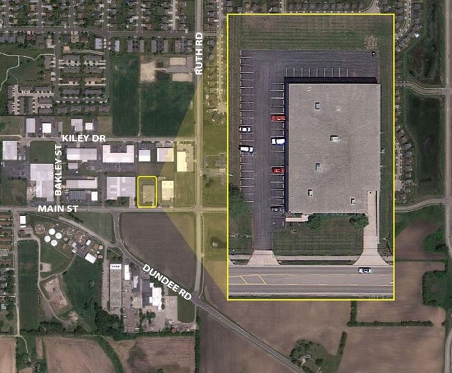
Property Detail
11200 Main St
Chicago-Naperville-Elgin, IL-IN
DOC 2013R0041133 LT 9 BAKLEYS 14TH ADDN
18-28-476-012
McHenry
Industrialgeneral
Illinois
B and X Area of moderate flood hazard, usually the area between the limits of the 100-year and 500-year floods.
9
2024
2.07 AC
2024
McHenry County
871114
Chicago
22,980 SF
NEARBY LISTINGS FOR SALE OR LEASE
DEMOGRAPHICS near 11200 Main St
1 mile
3 mile
5 mile
2025 Total Population
9,180
46,610
96,408
2030 Population
9,395
47,411
97,966
Pop Growth 2025-2030
+ 2.34%
+ 1.72%
+ 1.62%
Average Age
38
42
42
2025 Total Households
2,959
16,387
34,767
HH Growth 2025-2030
+ 2.47%
+ 1.79%
+ 1.66%
Median Household Inc
$114,262
$112,984
$112,304
Avg Household Size
3.00
2.80
2.70
2025 Avg HH Vehicles
2.00
2.00
2.00
Median Home Value
$342,163
$355,076
$349,318
Median Year Built
2001
2002
1999
Nearby Places
Map Layers
Map Styles
 Street
 Aerial
Layers
 Traffic
 Biking
Places
Listings with unknown addresses are not visible on the map
- Restaurants
- Banks
- Shops
- Fitness
- Groceries
PUBLIC TRANSPORTATION
AIRPORT
Chicago O'Hare International
Drive
Walk
Distance
Chicago O'Hare International
66 min
38.4 mi
Chicago/Rockford International
Drive
Walk
Distance
Chicago/Rockford International
60 min
44.8 mi
Nearby Properties
Address
Land Use
TOTAL SIZE
Lot Size
Zoning
Address
Land Use
TOTAL SIZE
Lot Size
Zoning
Address
Land Use
TOTAL SIZE
Lot Size
Zoning
Address
Land Use
TOTAL SIZE
Lot Size
Zoning
Address
Land Use
TOTAL SIZE
Lot Size
Zoning
Address
Land Use
TOTAL SIZE
Lot Size
Zoning
7.26 AC
Address
Land Use
TOTAL SIZE
Lot Size
Zoning
11.86 AC
Address
Land Use
TOTAL SIZE
Lot Size
Zoning
189,735 SF
21.85 AC
Address
Land Use
TOTAL SIZE
Lot Size
Zoning
3.50 AC
Address
Land Use
TOTAL SIZE
Lot Size
Zoning
Address
Land Use
TOTAL SIZE
Lot Size
Zoning
0.71 AC
Address
Land Use
TOTAL SIZE
Lot Size
Zoning
66,164 SF
9.90 AC
Address
Land Use
TOTAL SIZE
Lot Size
Zoning
9.28 AC
Address
Land Use
TOTAL SIZE
Lot Size
Zoning
8.23 AC
Address
Land Use
TOTAL SIZE
Lot Size
Zoning
57,813 SF
4.11 AC
Address
Land Use
TOTAL SIZE
Lot Size
Zoning
Address
Land Use
TOTAL SIZE
Lot Size
Zoning
11.15 AC
Address
Land Use
TOTAL SIZE
Lot Size
Zoning
92,850 SF
5 AC
Address
Land Use
TOTAL SIZE
Lot Size
Zoning
24,700 SF
3.08 AC
Address
Land Use
TOTAL SIZE
Lot Size
Zoning
3,144 SF
4.81 AC
Address
Land Use
TOTAL SIZE
Lot Size
Zoning
85,500 SF
7 AC
Address
Land Use
TOTAL SIZE
Lot Size
Zoning
2.55 AC
Address
Land Use
TOTAL SIZE
Lot Size
Zoning
22,200 SF
3.01 AC
Address
Land Use
TOTAL SIZE
Lot Size
Zoning
5.40 AC
Address
Land Use
TOTAL SIZE
Lot Size
Zoning
14,606 SF
2.14 AC
Address
Land Use
TOTAL SIZE
Lot Size
Zoning
0.27 AC
Address
Land Use
TOTAL SIZE
Lot Size
Zoning
24,157 SF
1.97 AC
Address
Land Use
TOTAL SIZE
Lot Size
Zoning
22,502 SF
4.92 AC
Address
Land Use
TOTAL SIZE
Lot Size
Zoning
71,064 SF
7 AC
Address
Land Use
TOTAL SIZE
Lot Size
Zoning
65,235 SF
4.74 AC
Address
Land Use
TOTAL SIZE
Lot Size
Zoning
48,150 SF
3.42 AC
The World's #1 Commercial Real Estate Marketplace
Connect with us
© 2026 CoStar Group
The information above has been obtained from sources believed reliable. While we do not doubt its accuracy we have not verified it and make no guarantee, warranty or representation about it. It is your responsibility to independently confirm its accuracy and completeness. Any projections, opinions, assumptions, or estimates used are for example only and do not represent the current or future performance of the property. The value of this transaction to you depends on tax and other factors which should be evaluated by your tax, financial, and legal advisors. You and your advisors should conduct a careful, independent investigation of the property to determine to your satisfaction the suitability of the property for your needs.