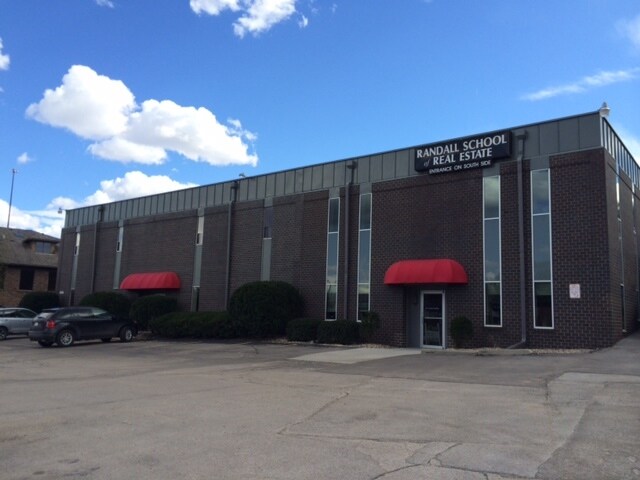
Property Record
11217 Wright Cir, Omaha, NE 68144


Property Detail
11217 Wright Cir
4805-0532-17
MILLERS PLAZA LOT 6 BLOCK 0 W 142 FT LT 6
Officebuilding
Douglas
GO
Nebraska
B and X Area of moderate flood hazard, usually the area between the limits of the 100-year and 500-year floods.
6
2024
0.75 AC
2025
Southwest Omaha
006903
Omaha/Council Bluffs
10,944 SF
Omaha, NE-IA
NEARBY LISTINGS FOR SALE OR LEASE
DEMOGRAPHICS near 11217 Wright Cir
1 mile
3 mile
5 mile
2025 Total Population
9,089
80,766
243,443
2030 Population
9,200
82,394
249,108
Pop Growth 2025-2030
+ 1.22%
+ 2.02%
+ 2.33%
Average Age
41
40
40
2025 Total Households
3,653
35,872
103,187
HH Growth 2025-2030
+ 1.40%
+ 2.24%
+ 2.55%
Median Household Inc
$97,359
$76,248
$80,342
Avg Household Size
2.50
2.20
2.30
2025 Avg HH Vehicles
2.00
2.00
2.00
Median Home Value
$288,195
$281,412
$272,617
Median Year Built
1964
1973
1978
Nearby Places
Map Layers
Map Styles
 Street
 Aerial
Transit
 Traffic
 Biking
Places
Listings with unknown addresses are not visible on the map
- Restaurants
- Banks
- Shops
- Fitness
- Groceries
PUBLIC TRANSPORTATION
AIRPORT
Eppley Airfield
Drive
Walk
Distance
Eppley Airfield
24 min
14.8 mi
Freight Ports
Tulsa Port Of Catoosa
Drive
Walk
Distance
Tulsa Port Of Catoosa
470 min
423.9 mi
SALE & LEASE HISTORY
LISTING DATE
SALE/LEASE

Sep 25, 2016
For Lease
Oct 22, 2018
For Lease
Nov 30, 2018
For Lease
Feb 23, 2024
For Lease
Feb 01, 2018
For Lease
Nearby Properties
Address
Land Use
TOTAL SIZE
Lot Size
Zoning
Address
Land Use
TOTAL SIZE
Lot Size
Zoning
866,622 SF
20.67 AC
Address
Land Use
TOTAL SIZE
Lot Size
Zoning
496,976 SF
12 AC
Address
Land Use
TOTAL SIZE
Lot Size
Zoning
856,187 SF
36.41 AC
Address
Land Use
TOTAL SIZE
Lot Size
Zoning
549,971 SF
42.84 AC
R6
Address
Land Use
TOTAL SIZE
Lot Size
Zoning
702,563 SF
18.85 AC
Address
Land Use
TOTAL SIZE
Lot Size
Zoning
209,917 SF
9.52 AC
Address
Land Use
TOTAL SIZE
Lot Size
Zoning
545,041 SF
22.69 AC
R6
Address
Land Use
TOTAL SIZE
Lot Size
Zoning
370,890 SF
11.20 AC
CC
Address
Land Use
TOTAL SIZE
Lot Size
Zoning
503,886 SF
25.40 AC
Address
Land Use
TOTAL SIZE
Lot Size
Zoning
250,386 SF
17.06 AC
Address
Land Use
TOTAL SIZE
Lot Size
Zoning
398,593 SF
10.80 AC
Address
Land Use
TOTAL SIZE
Lot Size
Zoning
130,286 SF
4.31 AC
GO
Address
Land Use
TOTAL SIZE
Lot Size
Zoning
96,871 SF
9.98 AC
Address
Land Use
TOTAL SIZE
Lot Size
Zoning
238,954 SF
14.65 AC
Address
Land Use
TOTAL SIZE
Lot Size
Zoning
282,180 SF
13.96 AC
Address
Land Use
TOTAL SIZE
Lot Size
Zoning
897,738 SF
52.16 AC
Address
Land Use
TOTAL SIZE
Lot Size
Zoning
329,515 SF
6.37 AC
Address
Land Use
TOTAL SIZE
Lot Size
Zoning
354,299 SF
22.85 AC
R6
Address
Land Use
TOTAL SIZE
Lot Size
Zoning
423,905 SF
21.96 AC
GI
Address
Land Use
TOTAL SIZE
Lot Size
Zoning
281,964 SF
18.15 AC
R6
Address
Land Use
TOTAL SIZE
Lot Size
Zoning
199,152 SF
13.44 AC
R6
Address
Land Use
TOTAL SIZE
Lot Size
Zoning
271,344 SF
9.78 AC
Address
Land Use
TOTAL SIZE
Lot Size
Zoning
274,072 SF
12.06 AC
Address
Land Use
TOTAL SIZE
Lot Size
Zoning
271,404 SF
17.51 AC
Address
Land Use
TOTAL SIZE
Lot Size
Zoning
309,162 SF
15.54 AC
Address
Land Use
TOTAL SIZE
Lot Size
Zoning
234,332 SF
12.30 AC
Address
Land Use
TOTAL SIZE
Lot Size
Zoning
268,545 SF
7.53 AC
Address
Land Use
TOTAL SIZE
Lot Size
Zoning
124,820 SF
9.69 AC
MU
Address
Land Use
TOTAL SIZE
Lot Size
Zoning
286,445 SF
16.18 AC
R6
The World's #1 Commercial Real Estate Marketplace
Connect with us
© 2026 CoStar Group
The information above has been obtained from sources believed reliable. While we do not doubt its accuracy we have not verified it and make no guarantee, warranty or representation about it. It is your responsibility to independently confirm its accuracy and completeness. Any projections, opinions, assumptions, or estimates used are for example only and do not represent the current or future performance of the property. The value of this transaction to you depends on tax and other factors which should be evaluated by your tax, financial, and legal advisors. You and your advisors should conduct a careful, independent investigation of the property to determine to your satisfaction the suitability of the property for your needs.