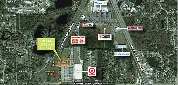
Property Record
1122 Dale Mabry Hwy, Lutz, FL 33548


NEARBY LISTINGS FOR SALE OR LEASE
Property Detail
1122 Dale Mabry Hwy
Tampa-St. Petersburg-Clearwater, FL
Dale Mabry Town Center
35-26-18-0140-00000-0010
Pasco
Financialbuilding
Florida
X
1.40 AC
12101C0411F
Pasco County
4,095 SF
Tampa/St Petersburg
DEMOGRAPHICS near 1122 Dale Mabry Hwy
1 Mile
3 Mile
5 Mile
2024 Total Population
5,243
39,245
114,965
2029 Population
6,266
45,531
133,489
Pop Growth 2024-2029
+ 19.51%
+ 16.02%
+ 16.11%
Average Age
41
41
40
2024 Total Households
2,056
14,578
42,401
HH Growth 2024-2029
+ 19.80%
+ 16.46%
+ 16.23%
Median Household Inc
$98,247
$112,197
$100,069
Avg Household Size
2.50
2.70
2.70
2024 Avg HH Vehicles
2.00
2.00
2.00
Median Home Value
$374,474
$388,996
$364,882
Median Year Built
2000
2000
2000
Nearby Places
Map Layers
Map Styles
 Street
 Aerial
- Restaurants
- Banks
- Shops
- Fitness
- Groceries
PUBLIC TRANSPORTATION
AIRPORT
Tampa International
DRIVE
WALK
Distance
Tampa International
32 min
21.4 mi
St Pete-Clearwater International
DRIVE
WALK
Distance
St Pete-Clearwater International
52 min
33.0 mi
Freight Ports
Port of Tampa Bay
DRIVE
WALK
Distance
Port of Tampa Bay
34 min
19.6 mi
SALE & LEASE HISTORY
LISTING DATE
SALE/LEASE

Nov 27, 2019
For Sale
Nearby Properties
Address
Land Use
TOTAL SIZE
Lot Size
Zoning
Address
Land Use
TOTAL SIZE
Lot Size
Zoning
444,470 SF
147.09 AC
AR
Address
Land Use
TOTAL SIZE
Lot Size
Zoning
400,232 SF
59.04 AC
MPUD
Address
Land Use
TOTAL SIZE
Lot Size
Zoning
366,691 SF
51.90 AC
MPUD
Address
Land Use
TOTAL SIZE
Lot Size
Zoning
341,679 SF
19.87 AC
MPUD
Address
Land Use
TOTAL SIZE
Lot Size
Zoning
291,175 SF
19.43 AC
MPUD
Address
Land Use
TOTAL SIZE
Lot Size
Zoning
285,532 SF
57.73 AC
MF1
Address
Land Use
TOTAL SIZE
Lot Size
Zoning
207,337 SF
11.54 AC
PD
Address
Land Use
TOTAL SIZE
Lot Size
Zoning
138,949 SF
11.74 AC
MPUD
Address
Land Use
TOTAL SIZE
Lot Size
Zoning
2,850 SF
68.38 AC
PD
Address
Land Use
TOTAL SIZE
Lot Size
Zoning
92,467 SF
26.90 AC
MPUD
Address
Land Use
TOTAL SIZE
Lot Size
Zoning
62,050 SF
11.17 AC
PD
Address
Land Use
TOTAL SIZE
Lot Size
Zoning
85,151 SF
23.18 AC
C2
Address
Land Use
TOTAL SIZE
Lot Size
Zoning
102,882 SF
42.29 AC
MPUD
Address
Land Use
TOTAL SIZE
Lot Size
Zoning
74,366 SF
22.46 AC
PD
Address
Land Use
TOTAL SIZE
Lot Size
Zoning
88,803 SF
6.46 AC
C2
Address
Land Use
TOTAL SIZE
Lot Size
Zoning
63,500 SF
32.29 AC
PD
Address
Land Use
TOTAL SIZE
Lot Size
Zoning
129,324 SF
4.95 AC
C2
Address
Land Use
TOTAL SIZE
Lot Size
Zoning
80,719 SF
8.14 AC
PD
Address
Land Use
TOTAL SIZE
Lot Size
Zoning
109,726 SF
4.54 AC
C2
Address
Land Use
TOTAL SIZE
Lot Size
Zoning
195,182 SF
22.91 AC
MPUD
Address
Land Use
TOTAL SIZE
Lot Size
Zoning
133,367 SF
11.98 AC
CG
Address
Land Use
TOTAL SIZE
Lot Size
Zoning
91,241 SF
8.38 AC
ASC-1
Address
Land Use
TOTAL SIZE
Lot Size
Zoning
98,701 SF
2.09 AC
MPUD
Address
Land Use
TOTAL SIZE
Lot Size
Zoning
65,365 SF
8.68 AC
PD
Address
Land Use
TOTAL SIZE
Lot Size
Zoning
75,630 SF
8.17 AC
PD
Address
Land Use
TOTAL SIZE
Lot Size
Zoning
104,550 SF
14.03 AC
C2
Address
Land Use
TOTAL SIZE
Lot Size
Zoning
120,547 SF
40.64 AC
C2
Address
Land Use
TOTAL SIZE
Lot Size
Zoning
96,779 SF
7.10 AC
MPUD
Address
Land Use
TOTAL SIZE
Lot Size
Zoning
97,656 SF
1.87 AC
C2
Address
Land Use
TOTAL SIZE
Lot Size
Zoning
85,626 SF
14.47 AC
PD
The World's #1 Commercial Real Estate Marketplace
Connect with us
© 2025 CoStar Group
The information above has been obtained from sources believed reliable. While we do not doubt its accuracy we have not verified it and make no guarantee, warranty or representation about it. It is your responsibility to independently confirm its accuracy and completeness. Any projections, opinions, assumptions, or estimates used are for example only and do not represent the current or future performance of the property. The value of this transaction to you depends on tax and other factors which should be evaluated by your tax, financial, and legal advisors. You and your advisors should conduct a careful, independent investigation of the property to determine to your satisfaction the suitability of the property for your needs.