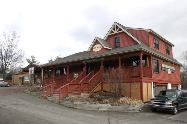
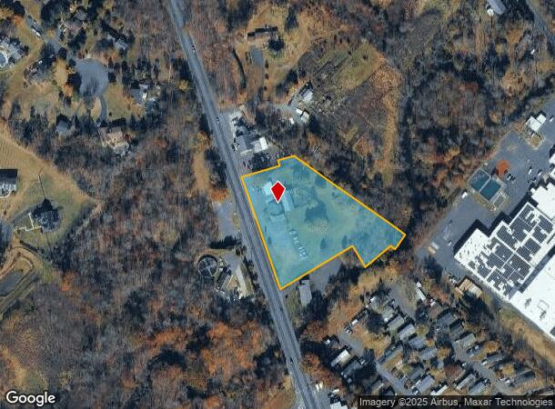
Property Record
1127 N Easton Rd, Doylestown, PA 18902
NEARBY LISTINGS FOR SALE OR LEASE
Property Detail
1127 N Easton Rd
34-011-060-005
3.135A E S US611 1570 FT S LR09021
Storebuilding
Bucks
A
Pennsylvania
42017C0282J
3.14 AC
2024
Upper Bucks County
2025
Philadelphia
104203
Philadelphia-Camden-Wilmington, PA-NJ-DE-MD
7,136 SF
DEMOGRAPHICS near 1127 N Easton Rd
1 Mile
3 Mile
5 Mile
2024 Total Population
1,362
21,236
58,072
2029 Population
1,345
20,998
57,944
Pop Growth 2024-2029
(1.25%)
(1.12%)
(0.22%)
Average Age
40
41
44
2024 Total Households
462
7,535
22,281
HH Growth 2024-2029
(1.52%)
(1.15%)
(0.04%)
Median Household Inc
$125,227
$132,087
$120,807
Avg Household Size
2.80
2.80
2.50
2024 Avg HH Vehicles
2.00
2.00
2.00
Median Home Value
$555,693
$512,057
$513,930
Median Year Built
1991
1992
1982
Nearby Places
Map Layers
Map Styles
 Street
 Aerial
- Restaurants
- Banks
- Shops
- Fitness
- Groceries
PUBLIC TRANSPORTATION
COMMUTER RAIL
Doylestown (R5 - Southeastern Pennsylvania Transportation Authority Regional Rail (SEPTA Regional Rail))
DRIVE
WALK
Distance
Doylestown (R5 - Southeastern Pennsylvania Transportation Authority Regional Rail (SEPTA Regional Rail))
8 min
4.6 mi
Delaware Valley College (R5 - Southeastern Pennsylvania Transportation Authority Regional Rail (SEPTA Regional Rail))
DRIVE
WALK
Distance
Delaware Valley College (R5 - Southeastern Pennsylvania Transportation Authority Regional Rail (SEPTA Regional Rail))
9 min
5.5 mi
AIRPORT
Trenton Mercer
DRIVE
WALK
Distance
Trenton Mercer
41 min
24.8 mi
Lehigh Valley International
DRIVE
WALK
Distance
Lehigh Valley International
56 min
32.5 mi
Freight Ports
Port of Philadelphia
DRIVE
WALK
Distance
Port of Philadelphia
53 min
29.8 mi
Nearby Properties
Address
Land Use
TOTAL SIZE
Lot Size
Zoning
Address
Land Use
TOTAL SIZE
Lot Size
Zoning
192,365 SF
30.81 AC
C2
Address
Land Use
TOTAL SIZE
Lot Size
Zoning
91,222 SF
13.75 AC
R2
Address
Land Use
TOTAL SIZE
Lot Size
Zoning
109,660 SF
9.81 AC
R3
Address
Land Use
TOTAL SIZE
Lot Size
Zoning
97,496 SF
12.67 AC
R3
Address
Land Use
TOTAL SIZE
Lot Size
Zoning
60,500 SF
5.90 AC
C2
Address
Land Use
TOTAL SIZE
Lot Size
Zoning
32,319 SF
7.30 AC
C1
Address
Land Use
TOTAL SIZE
Lot Size
Zoning
50,049 SF
5.45 AC
PC1
Address
Land Use
TOTAL SIZE
Lot Size
Zoning
515 SF
128.48 AC
R1
Address
Land Use
TOTAL SIZE
Lot Size
Zoning
66,008 SF
13.28 AC
C3
Address
Land Use
TOTAL SIZE
Lot Size
Zoning
25,479 SF
15.35 AC
I
Address
Land Use
TOTAL SIZE
Lot Size
Zoning
234,274 SF
24.12 AC
C4
Address
Land Use
TOTAL SIZE
Lot Size
Zoning
85,416 SF
4.30 AC
PC1
Address
Land Use
TOTAL SIZE
Lot Size
Zoning
72,320 SF
17.82 AC
I
Address
Land Use
TOTAL SIZE
Lot Size
Zoning
15,336 SF
9.10 AC
R3
Address
Land Use
TOTAL SIZE
Lot Size
Zoning
45,953 SF
2.12 AC
C2
Address
Land Use
TOTAL SIZE
Lot Size
Zoning
27,042 SF
4.02 AC
C1
Address
Land Use
TOTAL SIZE
Lot Size
Zoning
2,000 SF
8.62 AC
PI
Address
Land Use
TOTAL SIZE
Lot Size
Zoning
19,348 SF
4.86 AC
I
Address
Land Use
TOTAL SIZE
Lot Size
Zoning
61,059 SF
11.43 AC
I
Address
Land Use
TOTAL SIZE
Lot Size
Zoning
23,975 SF
4.34 AC
C1
Address
Land Use
TOTAL SIZE
Lot Size
Zoning
25,008 SF
4.05 AC
I
Address
Land Use
TOTAL SIZE
Lot Size
Zoning
12,309 SF
2.24 AC
C2
Address
Land Use
TOTAL SIZE
Lot Size
Zoning
10,671 SF
5.44 AC
P1
Address
Land Use
TOTAL SIZE
Lot Size
Zoning
78,057 SF
10.50 AC
I
Address
Land Use
TOTAL SIZE
Lot Size
Zoning
18,010 SF
4.34 AC
C2
Address
Land Use
TOTAL SIZE
Lot Size
Zoning
36,664 SF
5.10 AC
I
Address
Land Use
TOTAL SIZE
Lot Size
Zoning
12,824 SF
4.03 AC
C2
Address
Land Use
TOTAL SIZE
Lot Size
Zoning
40,000 SF
7.36 AC
P1
Address
Land Use
TOTAL SIZE
Lot Size
Zoning
49,383 SF
4.45 AC
I
Address
Land Use
TOTAL SIZE
Lot Size
Zoning
1,808 SF
3 AC
I
The World's #1 Commercial Real Estate Marketplace
Connect with us
© 2025 CoStar Group
The information above has been obtained from sources believed reliable. While we do not doubt its accuracy we have not verified it and make no guarantee, warranty or representation about it. It is your responsibility to independently confirm its accuracy and completeness. Any projections, opinions, assumptions, or estimates used are for example only and do not represent the current or future performance of the property. The value of this transaction to you depends on tax and other factors which should be evaluated by your tax, financial, and legal advisors. You and your advisors should conduct a careful, independent investigation of the property to determine to your satisfaction the suitability of the property for your needs.