Property Record
113 Heden Rd, Chehalis, WA 98532
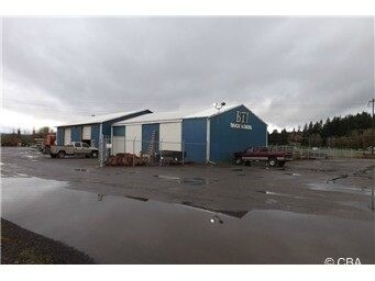

Property Detail
113 Heden Rd
Centralia, WA
SECTION 01 TOWNSHIP 13N RANGE 03W PTN GOV LOT 10 LY NWLY SLOUGH
018493-002-001
Lewis
Commercialnec
Washington
ARL
10
2024
9.30 AC
2025
Washington State Area
971400
Other Market Areas
1,404 SF
NEARBY LISTINGS FOR SALE OR LEASE
DEMOGRAPHICS near 113 Heden Rd
1 mile
3 mile
5 mile
2025 Total Population
337
9,577
21,743
2030 Population
346
9,873
22,529
Pop Growth 2025-2030
+ 2.67%
+ 3.09%
+ 3.61%
Average Age
44
40
40
2025 Total Households
124
3,613
8,307
HH Growth 2025-2030
+ 3.23%
+ 3.04%
+ 3.60%
Median Household Inc
$122,499
$83,832
$76,418
Avg Household Size
2.70
2.50
2.50
2025 Avg HH Vehicles
3.00
2.00
2.00
Median Home Value
$578,704
$421,154
$414,942
Median Year Built
1990
1973
1980
Nearby Places
Map Layers
Map Styles
 Street
 Aerial
Layers
 Traffic
 Biking
Places
Listings with unknown addresses are not visible on the map
- Restaurants
- Banks
- Shops
- Fitness
- Groceries
PUBLIC TRANSPORTATION
COMMUTER RAIL
Drive
Walk
Distance
13 min
6.8 mi
Freight Ports
Port of Long View, WA
Drive
Walk
Distance
Port of Long View, WA
56 min
43.8 mi
Nearby Properties
Address
Land Use
TOTAL SIZE
Lot Size
Zoning
Address
Land Use
TOTAL SIZE
Lot Size
Zoning
83,945 SF
3.12 AC
ILCG
Address
Land Use
TOTAL SIZE
Lot Size
Zoning
15,000 SF
66.30 AC
EPFI
Address
Land Use
TOTAL SIZE
Lot Size
Zoning
62,057 SF
2.08 AC
EPFG
Address
Land Use
TOTAL SIZE
Lot Size
Zoning
1,714 SF
220.30 AC
EPFA
Address
Land Use
TOTAL SIZE
Lot Size
Zoning
222,077 SF
Address
Land Use
TOTAL SIZE
Lot Size
Zoning
82,667 SF
Address
Land Use
TOTAL SIZE
Lot Size
Zoning
43,477 SF
8.64 AC
CG
Address
Land Use
TOTAL SIZE
Lot Size
Zoning
1,820 SF
34.64 AC
STMU
Address
Land Use
TOTAL SIZE
Lot Size
Zoning
3,742 SF
21.83 AC
EPFU
Address
Land Use
TOTAL SIZE
Lot Size
Zoning
2,741 SF
20.47 AC
EPFS
Address
Land Use
TOTAL SIZE
Lot Size
Zoning
4,361 SF
5.41 AC
R2
Address
Land Use
TOTAL SIZE
Lot Size
Zoning
94,044 SF
Address
Land Use
TOTAL SIZE
Lot Size
Zoning
13.11 AC
Address
Land Use
TOTAL SIZE
Lot Size
Zoning
83,043 SF
6.76 AC
CG
Address
Land Use
TOTAL SIZE
Lot Size
Zoning
31,418 SF
1.75 AC
CF
Address
Land Use
TOTAL SIZE
Lot Size
Zoning
56,121 SF
4.05 AC
ILCG
Address
Land Use
TOTAL SIZE
Lot Size
Zoning
22,974 SF
8.73 AC
CF
Address
Land Use
TOTAL SIZE
Lot Size
Zoning
23,490 SF
10.75 AC
RDD5
Address
Land Use
TOTAL SIZE
Lot Size
Zoning
4,185 SF
22.32 AC
EPFU
Address
Land Use
TOTAL SIZE
Lot Size
Zoning
1,040 SF
1.15 AC
CF
Address
Land Use
TOTAL SIZE
Lot Size
Zoning
36,846 SF
1.43 AC
R1
Address
Land Use
TOTAL SIZE
Lot Size
Zoning
4,128 SF
11.58 AC
EPFP
Address
Land Use
TOTAL SIZE
Lot Size
Zoning
38,712 SF
7.13 AC
ILCG
Address
Land Use
TOTAL SIZE
Lot Size
Zoning
39,680 SF
0.51 AC
EPFG
Address
Land Use
TOTAL SIZE
Lot Size
Zoning
10,063 SF
1.48 AC
R1
Address
Land Use
TOTAL SIZE
Lot Size
Zoning
39,670 SF
2.61 AC
ILCG
Address
Land Use
TOTAL SIZE
Lot Size
Zoning
16,730 SF
3.14 AC
EPFI
Address
Land Use
TOTAL SIZE
Lot Size
Zoning
37,522 SF
2.01 AC
CG
Address
Land Use
TOTAL SIZE
Lot Size
Zoning
28,088 SF
7.69 AC
CF
Address
Land Use
TOTAL SIZE
Lot Size
Zoning
10.36 AC
The World's #1 Commercial Real Estate Marketplace
Connect with us
© 2026 CoStar Group
The information above has been obtained from sources believed reliable. While we do not doubt its accuracy we have not verified it and make no guarantee, warranty or representation about it. It is your responsibility to independently confirm its accuracy and completeness. Any projections, opinions, assumptions, or estimates used are for example only and do not represent the current or future performance of the property. The value of this transaction to you depends on tax and other factors which should be evaluated by your tax, financial, and legal advisors. You and your advisors should conduct a careful, independent investigation of the property to determine to your satisfaction the suitability of the property for your needs.