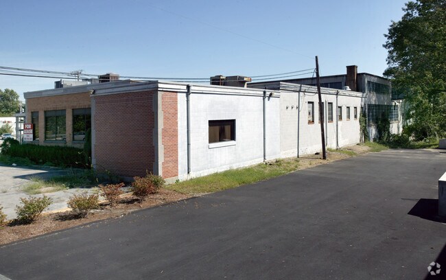
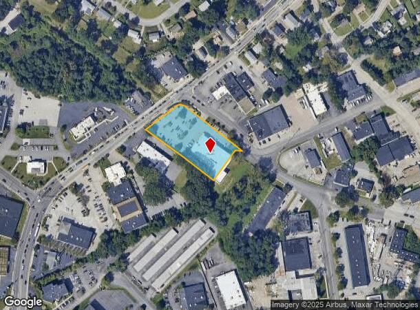
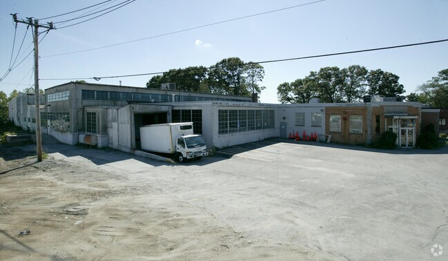
Property Record
1138 Pontiac Ave, Cranston, RI 02920
NEARBY LISTINGS FOR SALE OR LEASE
Property Detail
1138 Pontiac Ave
CRAN-000010-000004-000748
Providence
Commercialbuilding
Rhode Island
X
748
44003C0014H
1.08 AC
2025
Cranston
2025
Providence
013900
Providence-Warwick, RI-MA
17,588 SF
DEMOGRAPHICS near 1138 Pontiac Ave
1 Mile
3 Mile
5 Mile
2024 Total Population
6,738
90,869
266,109
2029 Population
6,743
90,850
265,093
Pop Growth 2024-2029
+ 0.07%
(0.02%)
(0.38%)
Average Age
44
43
40
2024 Total Households
3,037
37,319
106,467
HH Growth 2024-2029
0.00%
0.00%
(0.27%)
Median Household Inc
$73,558
$73,367
$63,772
Avg Household Size
2.20
2.30
2.40
2024 Avg HH Vehicles
2.00
2.00
2.00
Median Home Value
$306,905
$295,097
$297,041
Median Year Built
1958
1957
1956
Nearby Places
Map Layers
Map Styles
 Street
 Aerial
- Restaurants
- Banks
- Shops
- Fitness
- Groceries
PUBLIC TRANSPORTATION
COMMUTER RAIL
Tf Green Airport (Providence/Stoughton Line - MBTA)
DRIVE
WALK
Distance
Tf Green Airport (Providence/Stoughton Line - MBTA)
8 min
3.5 mi
Providence (Providence/Stoughton Line - Massachusetts Bay Transportation Authority Commuter Rail (Purple Line))
DRIVE
WALK
Distance
Providence (Providence/Stoughton Line - Massachusetts Bay Transportation Authority Commuter Rail (Purple Line))
14 min
7.5 mi
AIRPORT
Rhode Island Tf Green International
DRIVE
WALK
Distance
Rhode Island Tf Green International
10 min
4.4 mi
Freight Ports
Port of Davisville, RI
DRIVE
WALK
Distance
Port of Davisville, RI
27 min
15.8 mi
Nearby Properties
Address
Land Use
TOTAL SIZE
Lot Size
Zoning
Address
Land Use
TOTAL SIZE
Lot Size
Zoning
39.98 AC
S1
Address
Land Use
TOTAL SIZE
Lot Size
Zoning
45,000 SF
22.22 AC
M2
Address
Land Use
TOTAL SIZE
Lot Size
Zoning
13.40 AC
C3
Address
Land Use
TOTAL SIZE
Lot Size
Zoning
36.43 AC
S1
Address
Land Use
TOTAL SIZE
Lot Size
Zoning
33.13 AC
S1
Address
Land Use
TOTAL SIZE
Lot Size
Zoning
6,720 SF
0.01 AC
GB
Address
Land Use
TOTAL SIZE
Lot Size
Zoning
9.38 AC
S1
Address
Land Use
TOTAL SIZE
Lot Size
Zoning
4,954 SF
11.22 AC
C5
Address
Land Use
TOTAL SIZE
Lot Size
Zoning
4,212 SF
32.62 AC
S1
Address
Land Use
TOTAL SIZE
Lot Size
Zoning
485,238 SF
2.05 AC
GB
Address
Land Use
TOTAL SIZE
Lot Size
Zoning
6,702 SF
49.97 AC
GI
Address
Land Use
TOTAL SIZE
Lot Size
Zoning
411,032 SF
31.40 AC
GB
Address
Land Use
TOTAL SIZE
Lot Size
Zoning
27.47 AC
S1
Address
Land Use
TOTAL SIZE
Lot Size
Zoning
27.46 AC
C4
Address
Land Use
TOTAL SIZE
Lot Size
Zoning
517,743 SF
3.55 AC
GI
Address
Land Use
TOTAL SIZE
Lot Size
Zoning
102,425 SF
11.66 AC
S1
Address
Land Use
TOTAL SIZE
Lot Size
Zoning
491,496 SF
46.72 AC
LI
Address
Land Use
TOTAL SIZE
Lot Size
Zoning
247,671 SF
10.78 AC
A7
Address
Land Use
TOTAL SIZE
Lot Size
Zoning
10.78 AC
MPD
Address
Land Use
TOTAL SIZE
Lot Size
Zoning
57,068 SF
3.73 AC
Address
Land Use
TOTAL SIZE
Lot Size
Zoning
25 AC
CI
Address
Land Use
TOTAL SIZE
Lot Size
Zoning
Address
Land Use
TOTAL SIZE
Lot Size
Zoning
2,308 SF
12.82 AC
B2
Address
Land Use
TOTAL SIZE
Lot Size
Zoning
12.81 AC
A8
Address
Land Use
TOTAL SIZE
Lot Size
Zoning
81,129 SF
5.75 AC
A8
Address
Land Use
TOTAL SIZE
Lot Size
Zoning
100,638 SF
6.80 AC
GB
Address
Land Use
TOTAL SIZE
Lot Size
Zoning
139,256 SF
29.40 AC
GB
Address
Land Use
TOTAL SIZE
Lot Size
Zoning
243,057 SF
9.59 AC
GB
Address
Land Use
TOTAL SIZE
Lot Size
Zoning
116,940 SF
23.17 AC
Address
Land Use
TOTAL SIZE
Lot Size
Zoning
11.17 AC
A20
The World's #1 Commercial Real Estate Marketplace
Connect with us
© 2025 CoStar Group
The information above has been obtained from sources believed reliable. While we do not doubt its accuracy we have not verified it and make no guarantee, warranty or representation about it. It is your responsibility to independently confirm its accuracy and completeness. Any projections, opinions, assumptions, or estimates used are for example only and do not represent the current or future performance of the property. The value of this transaction to you depends on tax and other factors which should be evaluated by your tax, financial, and legal advisors. You and your advisors should conduct a careful, independent investigation of the property to determine to your satisfaction the suitability of the property for your needs.