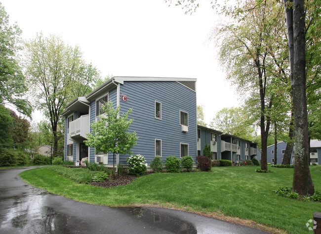
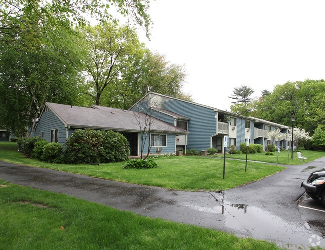
Property Record
114 Emerson Rd, Longmeadow, MA 01106

Save to a Folder
{{folder.Name}}
{{folder.ListingIds.length}} Properties
{{folder.ListingIds.length}} Property
Create a New Folder
Property Detail
114 Emerson Rd
LONG-000276-000028-000010
Hampden
Apartment
Massachusetts
RA1
10
B and X Area of moderate flood hazard, usually the area between the limits of the 100-year and 500-year floods.
11.51 AC
2025
East Hampden County
2025
Hartford
813301
Springfield, MA
NEARBY LISTINGS FOR SALE OR LEASE
DEMOGRAPHICS near 114 Emerson Rd
1 mile
3 mile
5 mile
2025 Total Population
5,913
66,971
188,572
2030 Population
5,900
66,682
188,722
Pop Growth 2025-2030
(0.22%)
(0.43%)
+ 0.08%
Average Age
41
40
40
2025 Total Households
2,059
25,822
72,534
HH Growth 2025-2030
(0.29%)
(0.41%)
+ 0.09%
Median Household Inc
$152,330
$68,331
$60,817
Avg Household Size
2.80
2.50
2.40
2025 Avg HH Vehicles
2.00
2.00
1.00
Median Home Value
$422,351
$322,513
$286,980
Median Year Built
1948
1953
1953
Nearby Places
Map Layers
Map Styles
 Street
 Aerial
Layers
 Traffic
 Biking
Places
Listings with unknown addresses are not visible on the map
- Restaurants
- Banks
- Shops
- Fitness
- Groceries
PUBLIC TRANSPORTATION
COMMUTER RAIL
Springfield (Hartford Line - CONN DOT)
Drive
Walk
Distance
Springfield (Hartford Line - CONN DOT)
9 min
4.3 mi
AIRPORT
Bradley International
Drive
Walk
Distance
Bradley International
32 min
13.1 mi
Freight Ports
Port of New Haven
Drive
Walk
Distance
Port of New Haven
83 min
61.8 mi
Nearby Properties
Address
Land Use
TOTAL SIZE
Lot Size
Zoning
Address
Land Use
TOTAL SIZE
Lot Size
Zoning
236,616 SF
31.07 AC
RA1
Address
Land Use
TOTAL SIZE
Lot Size
Zoning
162,232 SF
3.06 AC
R2
Address
Land Use
TOTAL SIZE
Lot Size
Zoning
82,248 SF
4.57 AC
SR3C1
Address
Land Use
TOTAL SIZE
Lot Size
Zoning
227,072 SF
4.37 AC
B3
Address
Land Use
TOTAL SIZE
Lot Size
Zoning
69.62 AC
MFHD
Address
Land Use
TOTAL SIZE
Lot Size
Zoning
839,347 SF
2.05 AC
B3
Address
Land Use
TOTAL SIZE
Lot Size
Zoning
100,000 SF
17.80 AC
WC
Address
Land Use
TOTAL SIZE
Lot Size
Zoning
8,712 SF
25.08 AC
RA1
Address
Land Use
TOTAL SIZE
Lot Size
Zoning
42,412 SF
2.22 AC
SR2B1
Address
Land Use
TOTAL SIZE
Lot Size
Zoning
24,835 SF
2.16 AC
B3
Address
Land Use
TOTAL SIZE
Lot Size
Zoning
9.69 AC
B
Address
Land Use
TOTAL SIZE
Lot Size
Zoning
1,840 SF
148.78 AC
BB
Address
Land Use
TOTAL SIZE
Lot Size
Zoning
84,605 SF
13.15 AC
RB
Address
Land Use
TOTAL SIZE
Lot Size
Zoning
4,400 SF
675 AC
SR1R2
Address
Land Use
TOTAL SIZE
Lot Size
Zoning
65.52 AC
BR
Address
Land Use
TOTAL SIZE
Lot Size
Zoning
137,450 SF
16 AC
Address
Land Use
TOTAL SIZE
Lot Size
Zoning
62,548 SF
10.50 AC
R1
Address
Land Use
TOTAL SIZE
Lot Size
Zoning
19,380 SF
3.30 AC
R2
Address
Land Use
TOTAL SIZE
Lot Size
Zoning
171,105 SF
14.21 AC
Address
Land Use
TOTAL SIZE
Lot Size
Zoning
55,881 SF
2 AC
R2
Address
Land Use
TOTAL SIZE
Lot Size
Zoning
53,298 SF
7.23 AC
PRO
Address
Land Use
TOTAL SIZE
Lot Size
Zoning
183,248 SF
4.47 AC
R4
Address
Land Use
TOTAL SIZE
Lot Size
Zoning
154,126 SF
9.27 AC
Address
Land Use
TOTAL SIZE
Lot Size
Zoning
48,012 SF
0.25 AC
R2
Address
Land Use
TOTAL SIZE
Lot Size
Zoning
80,144 SF
CR
Address
Land Use
TOTAL SIZE
Lot Size
Zoning
19,122 SF
2.30 AC
R2
Address
Land Use
TOTAL SIZE
Lot Size
Zoning
18.51 AC
BA
Address
Land Use
TOTAL SIZE
Lot Size
Zoning
51,555 SF
4.11 AC
Address
Land Use
TOTAL SIZE
Lot Size
Zoning
56,700 SF
1.74 AC
R3
Address
Land Use
TOTAL SIZE
Lot Size
Zoning
144,591 SF
2.36 AC
B3
The World's #1 Commercial Real Estate Marketplace
Connect with us
© 2026 CoStar Group
The information above has been obtained from sources believed reliable. While we do not doubt its accuracy we have not verified it and make no guarantee, warranty or representation about it. It is your responsibility to independently confirm its accuracy and completeness. Any projections, opinions, assumptions, or estimates used are for example only and do not represent the current or future performance of the property. The value of this transaction to you depends on tax and other factors which should be evaluated by your tax, financial, and legal advisors. You and your advisors should conduct a careful, independent investigation of the property to determine to your satisfaction the suitability of the property for your needs.