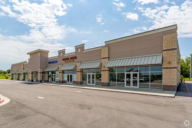
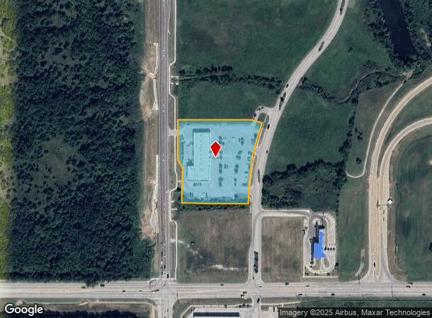
Property Record
1140 N 38Th St, Broken Arrow, OK 74014
NEARBY LISTINGS FOR SALE OR LEASE
Property Detail
1140 N 38Th St
Tulsa, OK
Northeast Crossroads
730080947
NORTHEAST CROSSROADS PT OF LOT 1 BLOCK 2 DESC AS COMM AT THE SW CORN OF SD LOT 1 BLK 2, THENCE N01D 24'32"W 160.65', THENCE N
Communitycenter
Wagoner
X
Oklahoma
40145C0105J
1
2024
2.82 AC
2025
Wagoner County
030508
Tulsa
16,790 SF
DEMOGRAPHICS near 1140 N 38Th St
1 Mile
3 Mile
5 Mile
2024 Total Population
2,915
39,125
102,175
2029 Population
3,380
43,397
111,016
Pop Growth 2024-2029
+ 15.95%
+ 10.92%
+ 8.65%
Average Age
37
38
38
2024 Total Households
1,009
14,963
38,330
HH Growth 2024-2029
+ 15.86%
+ 10.64%
+ 8.37%
Median Household Inc
$59,530
$72,795
$76,636
Avg Household Size
2.80
2.60
2.60
2024 Avg HH Vehicles
2.00
2.00
2.00
Median Home Value
$174,273
$208,805
$205,293
Median Year Built
1984
2000
1996
Nearby Places
Map Layers
Map Styles
 Street
 Aerial
- Restaurants
- Banks
- Shops
- Fitness
- Groceries
PUBLIC TRANSPORTATION
AIRPORT
Tulsa International
DRIVE
WALK
Distance
Tulsa International
27 min
18.4 mi
Freight Ports
Tulsa Port of Inola
DRIVE
WALK
Distance
Tulsa Port of Inola
29 min
23.0 mi
SALE & LEASE HISTORY
LISTING DATE
SALE/LEASE

Sep 25, 2016
For Lease
Sep 24, 2016
For Sale
Sep 04, 2020
For Lease
Feb 14, 2018
For Lease
Nearby Properties
Address
Land Use
TOTAL SIZE
Lot Size
Zoning
Address
Land Use
TOTAL SIZE
Lot Size
Zoning
115,003 SF
59.09 AC
CG
Address
Land Use
TOTAL SIZE
Lot Size
Zoning
125,902 SF
19.15 AC
CH
Address
Land Use
TOTAL SIZE
Lot Size
Zoning
53,139 SF
108.91 AC
A1
Address
Land Use
TOTAL SIZE
Lot Size
Zoning
75,444 SF
23.92 AC
R1
Address
Land Use
TOTAL SIZE
Lot Size
Zoning
58,695 SF
5.34 AC
RM
Address
Land Use
TOTAL SIZE
Lot Size
Zoning
77,260 SF
0.58 AC
R3
Address
Land Use
TOTAL SIZE
Lot Size
Zoning
58,627 SF
6.07 AC
CG
Address
Land Use
TOTAL SIZE
Lot Size
Zoning
363,154 SF
23.09 AC
IL
Address
Land Use
TOTAL SIZE
Lot Size
Zoning
13,691 SF
2.04 AC
CH
Address
Land Use
TOTAL SIZE
Lot Size
Zoning
8.25 AC
CH
Address
Land Use
TOTAL SIZE
Lot Size
Zoning
28,071 SF
Address
Land Use
TOTAL SIZE
Lot Size
Zoning
28,348 SF
0.90 AC
DM
Address
Land Use
TOTAL SIZE
Lot Size
Zoning
6.75 AC
CH
Address
Land Use
TOTAL SIZE
Lot Size
Zoning
51,741 SF
2.41 AC
R3
Address
Land Use
TOTAL SIZE
Lot Size
Zoning
60,460 SF
2.28 AC
NCU
Address
Land Use
TOTAL SIZE
Lot Size
Zoning
153,125 SF
10.65 AC
RM2
Address
Land Use
TOTAL SIZE
Lot Size
Zoning
10,140 SF
18.57 AC
R1
Address
Land Use
TOTAL SIZE
Lot Size
Zoning
20,633 SF
5.53 AC
Address
Land Use
TOTAL SIZE
Lot Size
Zoning
314,047 SF
12.60 AC
RM
Address
Land Use
TOTAL SIZE
Lot Size
Zoning
12,782 SF
3.69 AC
CM
Address
Land Use
TOTAL SIZE
Lot Size
Zoning
279,184 SF
14.50 AC
RM
Address
Land Use
TOTAL SIZE
Lot Size
Zoning
27,477 SF
5.79 AC
R1
Address
Land Use
TOTAL SIZE
Lot Size
Zoning
11,605 SF
1.50 AC
OL
Address
Land Use
TOTAL SIZE
Lot Size
Zoning
286,516 SF
22.63 AC
RM
Address
Land Use
TOTAL SIZE
Lot Size
Zoning
255,328 SF
27.50 AC
IL
Address
Land Use
TOTAL SIZE
Lot Size
Zoning
21,960 SF
0.24 AC
CH
Address
Land Use
TOTAL SIZE
Lot Size
Zoning
38,842 SF
0.96 AC
DM
Address
Land Use
TOTAL SIZE
Lot Size
Zoning
10,700 SF
5.99 AC
RM
Address
Land Use
TOTAL SIZE
Lot Size
Zoning
11,795 SF
5.12 AC
R1
The World's #1 Commercial Real Estate Marketplace
Connect with us
© 2026 CoStar Group
The information above has been obtained from sources believed reliable. While we do not doubt its accuracy we have not verified it and make no guarantee, warranty or representation about it. It is your responsibility to independently confirm its accuracy and completeness. Any projections, opinions, assumptions, or estimates used are for example only and do not represent the current or future performance of the property. The value of this transaction to you depends on tax and other factors which should be evaluated by your tax, financial, and legal advisors. You and your advisors should conduct a careful, independent investigation of the property to determine to your satisfaction the suitability of the property for your needs.