Property Record
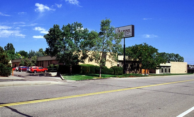
11425 W I 70 Frontage Rd N, Wheat Ridge, CO 80033

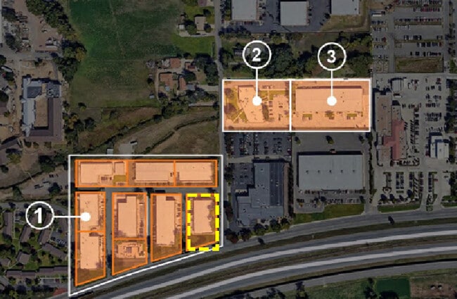

NEARBY LISTINGS FOR SALE OR LEASE
Property Detail
11425 W I 70 Frontage Rd N
Denver-Aurora-Lakewood, CO
Wheat Ridge Industrial Park
39-163-03-009
SECTION 16 TOWNSHIP 03 RANGE 69 SUBDIVISIONCD 830600 SUBDIVISIONNAME WHEAT RIDGE INDUSTRIAL PARK BLOCK LOT 0006 SIZE: 42253 TRACT VALUE: .970
Industrialgeneral
Jefferson
X
Colorado
08059C0192F
6
2023
0.97 AC
2024
Northwest Denver
010502
Denver
16,946 SF
DEMOGRAPHICS near 11425 W I 70 Frontage Rd N
1 Mile
3 Mile
5 Mile
2024 Total Population
7,530
91,355
241,577
2029 Population
7,610
90,840
239,918
Pop Growth 2024-2029
+ 1.06%
(0.56%)
(0.69%)
Average Age
42
42
41
2024 Total Households
3,544
39,503
102,184
HH Growth 2024-2029
+ 0.93%
(0.63%)
(0.74%)
Median Household Inc
$85,964
$87,256
$88,617
Avg Household Size
2.10
2.30
2.30
2024 Avg HH Vehicles
2.00
2.00
2.00
Median Home Value
$616,808
$596,208
$580,589
Median Year Built
1994
1972
1974
Nearby Places
Map Layers
Map Styles
 Street
 Aerial
- Restaurants
- Banks
- Shops
- Fitness
- Groceries
PUBLIC TRANSPORTATION
COMMUTER RAIL
DRIVE
WALK
Distance
3 min
15 min
0.8 mi
DRIVE
WALK
Distance
4 min
1.2 mi
AIRPORT
Denver International
DRIVE
WALK
Distance
Denver International
40 min
29.9 mi
SALE & LEASE HISTORY
LISTING DATE
SALE/LEASE

Aug 24, 2018
For Lease
Nearby Properties
Address
Land Use
TOTAL SIZE
Lot Size
Zoning
Address
Land Use
TOTAL SIZE
Lot Size
Zoning
830,160 SF
26.93 AC
Address
Land Use
TOTAL SIZE
Lot Size
Zoning
269,013 SF
31.89 AC
Address
Land Use
TOTAL SIZE
Lot Size
Zoning
111,673 SF
29.06 AC
Address
Land Use
TOTAL SIZE
Lot Size
Zoning
298,150 SF
24.21 AC
Address
Land Use
TOTAL SIZE
Lot Size
Zoning
187,095 SF
23.42 AC
Address
Land Use
TOTAL SIZE
Lot Size
Zoning
187,745 SF
16.25 AC
Address
Land Use
TOTAL SIZE
Lot Size
Zoning
353,286 SF
14.49 AC
Address
Land Use
TOTAL SIZE
Lot Size
Zoning
227,132 SF
11.95 AC
Address
Land Use
TOTAL SIZE
Lot Size
Zoning
365,230 SF
12.51 AC
Address
Land Use
TOTAL SIZE
Lot Size
Zoning
389,561 SF
10.73 AC
Address
Land Use
TOTAL SIZE
Lot Size
Zoning
131,135 SF
2.83 AC
Address
Land Use
TOTAL SIZE
Lot Size
Zoning
262,699 SF
13.10 AC
A2
Address
Land Use
TOTAL SIZE
Lot Size
Zoning
330,357 SF
15.16 AC
Address
Land Use
TOTAL SIZE
Lot Size
Zoning
363,989 SF
30.10 AC
Address
Land Use
TOTAL SIZE
Lot Size
Zoning
241,243 SF
9.08 AC
Address
Land Use
TOTAL SIZE
Lot Size
Zoning
101,761 SF
4.34 AC
Address
Land Use
TOTAL SIZE
Lot Size
Zoning
142,200 SF
9.82 AC
Address
Land Use
TOTAL SIZE
Lot Size
Zoning
520,896 SF
24.42 AC
I1
Address
Land Use
TOTAL SIZE
Lot Size
Zoning
2,997 SF
5.28 AC
Address
Land Use
TOTAL SIZE
Lot Size
Zoning
163,361 SF
17.09 AC
Address
Land Use
TOTAL SIZE
Lot Size
Zoning
125,884 SF
8.88 AC
Address
Land Use
TOTAL SIZE
Lot Size
Zoning
91,734 SF
9.69 AC
Address
Land Use
TOTAL SIZE
Lot Size
Zoning
144,325 SF
13.22 AC
Address
Land Use
TOTAL SIZE
Lot Size
Zoning
109,401 SF
12.19 AC
Address
Land Use
TOTAL SIZE
Lot Size
Zoning
114,348 SF
3 AC
Address
Land Use
TOTAL SIZE
Lot Size
Zoning
139,913 SF
2.87 AC
Address
Land Use
TOTAL SIZE
Lot Size
Zoning
121,389 SF
3.58 AC
Address
Land Use
TOTAL SIZE
Lot Size
Zoning
130,662 SF
9.67 AC
Address
Land Use
TOTAL SIZE
Lot Size
Zoning
223,338 SF
9.42 AC
I1
Address
Land Use
TOTAL SIZE
Lot Size
Zoning
149,760 SF
8.64 AC
The World's #1 Commercial Real Estate Marketplace
Connect with us
© 2026 CoStar Group
The information above has been obtained from sources believed reliable. While we do not doubt its accuracy we have not verified it and make no guarantee, warranty or representation about it. It is your responsibility to independently confirm its accuracy and completeness. Any projections, opinions, assumptions, or estimates used are for example only and do not represent the current or future performance of the property. The value of this transaction to you depends on tax and other factors which should be evaluated by your tax, financial, and legal advisors. You and your advisors should conduct a careful, independent investigation of the property to determine to your satisfaction the suitability of the property for your needs.