Property Record
11455 Westmoor Approx Dr, Westminster, CO 80021
NEARBY LISTINGS FOR SALE OR LEASE
Property Detail
11455 Westmoor Approx Dr
Denver-Aurora-Centennial, CO
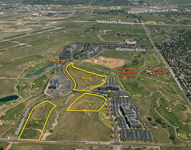
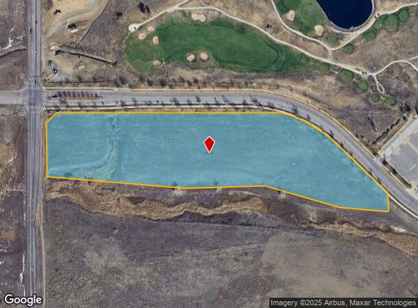
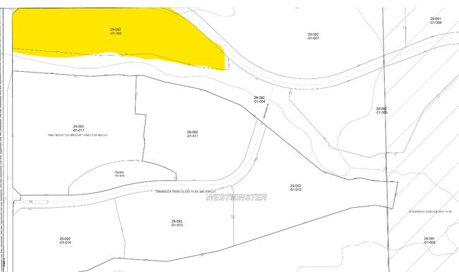
Westmoor Technology Park
29-092-01-003
SECTION 09 TOWNSHIP 02 RANGE 69 QTR NW SUBDIVISIONCD 826550 SUBDIVISIONNAME WESTMOOR TECHNOLOGY PARK BLOCK 004 LOT 0001 SIZE: 445807 TRACT VALUE: 10.234
Commercialnec
Jefferson
A
Colorado
08059C0070F
1
2023
10.23 AC
2024
Northwest Denver
009824
Denver
DEMOGRAPHICS near 11455 Westmoor Approx Dr
1 mile
3 mile
5 mile
2024 Total Population
3,593
49,391
152,848
2029 Population
3,548
50,953
156,253
Pop Growth 2024-2029
(1.25%)
+ 3.16%
+ 2.23%
Average Age
40
39
40
2024 Total Households
1,387
21,181
61,674
HH Growth 2024-2029
(0.87%)
+ 3.85%
+ 2.51%
Median Household Inc
$110,769
$96,059
$105,157
Avg Household Size
2.50
2.30
2.40
2024 Avg HH Vehicles
2.00
2.00
2.00
Median Home Value
$428,833
$479,478
$552,357
Median Year Built
1982
1993
1990
Nearby Places
Map Layers
Map Styles
 Street
 Aerial
Transit
 Traffic
 Biking
Places
Listings with unknown addresses are not visible on the map
- Restaurants
- Banks
- Shops
- Fitness
- Groceries
PUBLIC TRANSPORTATION
COMMUTER RAIL
Olde Town Arvada W-Bound (Union Station to Wheat Ridge Ward Station - Regional Transportation District)
Drive
Walk
Distance
Olde Town Arvada W-Bound (Union Station to Wheat Ridge Ward Station - Regional Transportation District)
17 min
9.7 mi
AIRPORT
Denver International
Drive
Walk
Distance
Denver International
43 min
36.5 mi
Freight Ports
Tulsa Port Of Catoosa
Drive
Walk
Distance
Tulsa Port Of Catoosa
744 min
720.5 mi
SALE & LEASE HISTORY
LISTING DATE
SALE/LEASE

Dec 16, 2016
For Sale
Nearby Properties
Address
Land Use
TOTAL SIZE
Lot Size
Zoning
Address
Land Use
TOTAL SIZE
Lot Size
Zoning
776,625 SF
41.29 AC
PUD
Address
Land Use
TOTAL SIZE
Lot Size
Zoning
431,902 SF
17.63 AC
Address
Land Use
TOTAL SIZE
Lot Size
Zoning
305,331 SF
14.41 AC
PUD
Address
Land Use
TOTAL SIZE
Lot Size
Zoning
117,775 SF
34.58 AC
GA; PUD
Address
Land Use
TOTAL SIZE
Lot Size
Zoning
57.62 AC
Address
Land Use
TOTAL SIZE
Lot Size
Zoning
211,191 SF
30.46 AC
Address
Land Use
TOTAL SIZE
Lot Size
Zoning
254,500 SF
13.42 AC
PUD
Address
Land Use
TOTAL SIZE
Lot Size
Zoning
49.69 AC
Address
Land Use
TOTAL SIZE
Lot Size
Zoning
41.05 AC
Address
Land Use
TOTAL SIZE
Lot Size
Zoning
233.17 AC
A
Address
Land Use
TOTAL SIZE
Lot Size
Zoning
209,009 SF
22.30 AC
Address
Land Use
TOTAL SIZE
Lot Size
Zoning
320,771 SF
18.60 AC
PUD
Address
Land Use
TOTAL SIZE
Lot Size
Zoning
254,500 SF
13 AC
PUD
Address
Land Use
TOTAL SIZE
Lot Size
Zoning
130,769 SF
18.61 AC
PUD
Address
Land Use
TOTAL SIZE
Lot Size
Zoning
643,992 SF
13.24 AC
PUD
Address
Land Use
TOTAL SIZE
Lot Size
Zoning
212,852 SF
12.82 AC
Address
Land Use
TOTAL SIZE
Lot Size
Zoning
187,920 SF
10.57 AC
PUD
Address
Land Use
TOTAL SIZE
Lot Size
Zoning
281,167 SF
19.52 AC
Address
Land Use
TOTAL SIZE
Lot Size
Zoning
159,724 SF
8.11 AC
Address
Land Use
TOTAL SIZE
Lot Size
Zoning
19.16 AC
Address
Land Use
TOTAL SIZE
Lot Size
Zoning
25.01 AC
Address
Land Use
TOTAL SIZE
Lot Size
Zoning
81.89 AC
A
Address
Land Use
TOTAL SIZE
Lot Size
Zoning
577,088 SF
18.94 AC
PUD
Address
Land Use
TOTAL SIZE
Lot Size
Zoning
211,827 SF
25.67 AC
Address
Land Use
TOTAL SIZE
Lot Size
Zoning
1,968.53 AC
Address
Land Use
TOTAL SIZE
Lot Size
Zoning
22.16 AC
Address
Land Use
TOTAL SIZE
Lot Size
Zoning
55.43 AC
A
Address
Land Use
TOTAL SIZE
Lot Size
Zoning
154,700 SF
9.03 AC
PUD
Address
Land Use
TOTAL SIZE
Lot Size
Zoning
528,256 SF
3.87 AC
PUD
Address
Land Use
TOTAL SIZE
Lot Size
Zoning
15.09 AC
The World's #1 Commercial Real Estate Marketplace
Connect with us
© 2026 CoStar Group
The information above has been obtained from sources believed reliable. While we do not doubt its accuracy we have not verified it and make no guarantee, warranty or representation about it. It is your responsibility to independently confirm its accuracy and completeness. Any projections, opinions, assumptions, or estimates used are for example only and do not represent the current or future performance of the property. The value of this transaction to you depends on tax and other factors which should be evaluated by your tax, financial, and legal advisors. You and your advisors should conduct a careful, independent investigation of the property to determine to your satisfaction the suitability of the property for your needs.