Property Record
1146 N Alma School Rd, Mesa, AZ 85201


Save to a Folder
{{folder.Name}}
{{folder.ListingIds.length}} Properties
{{folder.ListingIds.length}} Property
Create a New Folder
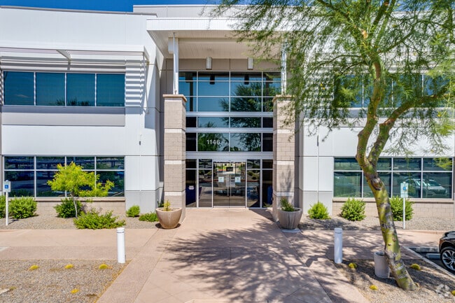
Property Detail
1146 N Alma School Rd
135-33-587
MESA RIVERVIEW PARCEL 1 LOT 34 MCR 1081-30
Officebuilding
Maricopa
PEP
Arizona
C and X Area of minimal flood hazard, usually depicted on FIRMs as above the 500-year flood level.
34
2025
5.88 AC
2025
Mesa East
421201
Phoenix
83,150 SF
Phoenix-Mesa-Chandler, AZ
NEARBY LISTINGS FOR SALE OR LEASE
DEMOGRAPHICS near 1146 N Alma School Rd
1 mile
3 mile
5 mile
2025 Total Population
8,942
132,029
352,107
2030 Population
9,208
137,849
366,362
Pop Growth 2025-2030
+ 2.97%
+ 4.41%
+ 4.05%
Average Age
37
36
36
2025 Total Households
3,282
53,117
138,010
HH Growth 2025-2030
+ 2.99%
+ 4.52%
+ 4.32%
Median Household Inc
$84,246
$59,007
$69,346
Avg Household Size
2.60
2.40
2.40
2025 Avg HH Vehicles
2.00
2.00
2.00
Median Home Value
$414,483
$345,521
$425,411
Median Year Built
1976
1982
1980
Nearby Places
Map Layers
Map Styles
 Street
 Aerial
Layers
 Traffic
 Biking
Places
Listings with unknown addresses are not visible on the map
- Restaurants
- Banks
- Shops
- Fitness
- Groceries
PUBLIC TRANSPORTATION
AIRPORT
Phoenix Sky Harbor International
Drive
Walk
Distance
Phoenix Sky Harbor International
16 min
10.0 mi
SALE & LEASE HISTORY
LISTING DATE
SALE/LEASE

Sep 25, 2016
For Lease
Jul 19, 2021
For Lease
Feb 08, 2018
For Lease
Aug 04, 2022
For Lease
Nearby Properties
Address
Land Use
TOTAL SIZE
Lot Size
Zoning
Address
Land Use
TOTAL SIZE
Lot Size
Zoning
8.79 AC
PF
Address
Land Use
TOTAL SIZE
Lot Size
Zoning
197,454 SF
18.97 AC
PF
Address
Land Use
TOTAL SIZE
Lot Size
Zoning
401,437 SF
17.70 AC
C-R
Address
Land Use
TOTAL SIZE
Lot Size
Zoning
377,442 SF
0.21 AC
C-DT
Address
Land Use
TOTAL SIZE
Lot Size
Zoning
564,649 SF
7.19 AC
RCC
Address
Land Use
TOTAL SIZE
Lot Size
Zoning
448,308 SF
6.30 AC
GID
Address
Land Use
TOTAL SIZE
Lot Size
Zoning
267,023 SF
19.58 AC
PEP
Address
Land Use
TOTAL SIZE
Lot Size
Zoning
782,618 SF
6.70 AC
PAD
Address
Land Use
TOTAL SIZE
Lot Size
Zoning
485,625 SF
45.99 AC
PF
Address
Land Use
TOTAL SIZE
Lot Size
Zoning
32,619 SF
2.40 AC
C-G
Address
Land Use
TOTAL SIZE
Lot Size
Zoning
435,896 SF
3.40 AC
PCC2
Address
Land Use
TOTAL SIZE
Lot Size
Zoning
501,927 SF
8.13 AC
GC
Address
Land Use
TOTAL SIZE
Lot Size
Zoning
407,570 SF
6.22 AC
PEP
Address
Land Use
TOTAL SIZE
Lot Size
Zoning
23,030 SF
0.99 AC
M-H
Address
Land Use
TOTAL SIZE
Lot Size
Zoning
454,015 SF
10.03 AC
DB1
Address
Land Use
TOTAL SIZE
Lot Size
Zoning
322,662 SF
9.29 AC
R-6
Address
Land Use
TOTAL SIZE
Lot Size
Zoning
1.46 AC
C-G
Address
Land Use
TOTAL SIZE
Lot Size
Zoning
526,950 SF
6.35 AC
PAD
Address
Land Use
TOTAL SIZE
Lot Size
Zoning
302,962 SF
6.58 AC
HID
Address
Land Use
TOTAL SIZE
Lot Size
Zoning
160,533 SF
7.59 AC
GC
Address
Land Use
TOTAL SIZE
Lot Size
Zoning
239,532 SF
9.94 AC
PCC-1
Address
Land Use
TOTAL SIZE
Lot Size
Zoning
387,531 SF
18.47 AC
M-H
Address
Land Use
TOTAL SIZE
Lot Size
Zoning
478,411 SF
4.07 AC
CDT
Address
Land Use
TOTAL SIZE
Lot Size
Zoning
247,808 SF
5.85 AC
MU4
Address
Land Use
TOTAL SIZE
Lot Size
Zoning
210,613 SF
15.50 AC
I-1
Address
Land Use
TOTAL SIZE
Lot Size
Zoning
337,024 SF
5.93 AC
GID
Address
Land Use
TOTAL SIZE
Lot Size
Zoning
199,472 SF
4.79 AC
C-DT
Address
Land Use
TOTAL SIZE
Lot Size
Zoning
152,199 SF
21.96 AC
C-G
Address
Land Use
TOTAL SIZE
Lot Size
Zoning
236,345 SF
10.28 AC
LC
Address
Land Use
TOTAL SIZE
Lot Size
Zoning
166,182 SF
11.71 AC
C-R
The World's #1 Commercial Real Estate Marketplace
Connect with us
© 2026 CoStar Group
The information above has been obtained from sources believed reliable. While we do not doubt its accuracy we have not verified it and make no guarantee, warranty or representation about it. It is your responsibility to independently confirm its accuracy and completeness. Any projections, opinions, assumptions, or estimates used are for example only and do not represent the current or future performance of the property. The value of this transaction to you depends on tax and other factors which should be evaluated by your tax, financial, and legal advisors. You and your advisors should conduct a careful, independent investigation of the property to determine to your satisfaction the suitability of the property for your needs.