Property Record
11506 Oxnard St, North Hollywood, CA 91606

Current Lease Availabilities
NEARBY LISTINGS FOR SALE OR LEASE
Property Detail
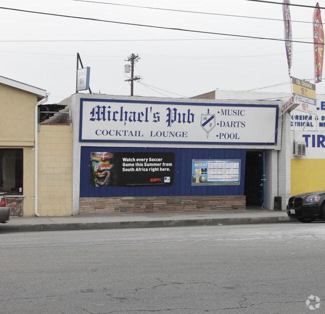
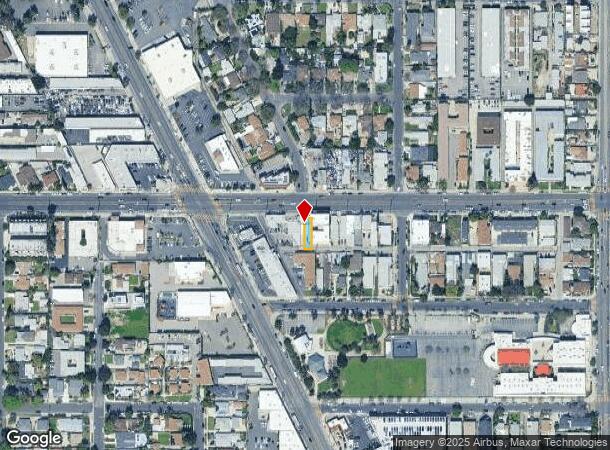
11506 Oxnard St
Los Angeles-Long Beach-Glendale, CA
9658
2338-010-013
TRACT # 9658 LOT 29
Restaurantbuilding
Los Angeles
X
California
06037C1320F
29
2024
0.06 AC
2025
North Hollywood
124102
Los Angeles
1,500 SF
DEMOGRAPHICS near 11506 Oxnard St
1 Mile
3 Mile
5 Mile
2024 Total Population
43,501
290,311
595,428
2029 Population
42,528
282,496
578,513
Pop Growth 2024-2029
(2.24%)
(2.69%)
(2.84%)
Average Age
38
40
40
2024 Total Households
16,680
113,828
226,479
HH Growth 2024-2029
(2.28%)
(2.85%)
(3.03%)
Median Household Inc
$57,947
$74,450
$76,973
Avg Household Size
2.50
2.50
2.50
2024 Avg HH Vehicles
2.00
2.00
2.00
Median Home Value
$771,728
$853,348
$869,932
Median Year Built
1965
1966
1966
Nearby Places
Map Layers
Map Styles
 Street
 Aerial
- Restaurants
- Banks
- Shops
- Fitness
- Groceries
PUBLIC TRANSPORTATION
TRANSIT/SUBWAY
North Hollywood Station (Orange Line - Los Angeles County Metropolitan Transportation Authority (Metro), Red Line - Los Angeles County Metropolitan Transportation Authority (Metro))
DRIVE
WALK
Distance
North Hollywood Station (Orange Line - Los Angeles County Metropolitan Transportation Authority (Metro), Red Line - Los Angeles County Metropolitan Transportation Authority (Metro))
1 min
16 min
0.9 mi
COMMUTER RAIL
Burbank-Bob Hope Airport (Ventura County Line - Southern California Regional Rail Authority (Metrolink))
DRIVE
WALK
Distance
Burbank-Bob Hope Airport (Ventura County Line - Southern California Regional Rail Authority (Metrolink))
6 min
3.2 mi
Burbank Airport - North (Av Line) Metrolink Station (Metrolink Antelope Valley Line - Metrolink Trains)
DRIVE
WALK
Distance
Burbank Airport - North (Av Line) Metrolink Station (Metrolink Antelope Valley Line - Metrolink Trains)
8 min
5.2 mi
AIRPORT
Bob Hope
DRIVE
WALK
Distance
Bob Hope
6 min
3.3 mi
Los Angeles International
DRIVE
WALK
Distance
Los Angeles International
35 min
23.9 mi
Long Beach (Daugherty Field)
DRIVE
WALK
Distance
Long Beach (Daugherty Field)
49 min
36.1 mi
Freight Ports
Port of Long Beach
DRIVE
WALK
Distance
Port of Long Beach
51 min
37.6 mi
Nearby Properties
Address
Land Use
TOTAL SIZE
Lot Size
Zoning
Address
Land Use
TOTAL SIZE
Lot Size
Zoning
65,532 SF
67.90 AC
LAM11/2*
Address
Land Use
TOTAL SIZE
Lot Size
Zoning
849,801 SF
59.25 AC
BUM2
Address
Land Use
TOTAL SIZE
Lot Size
Zoning
518,067 SF
17.27 AC
LAC4
Address
Land Use
TOTAL SIZE
Lot Size
Zoning
690,600 SF
6.57 AC
LACM
Address
Land Use
TOTAL SIZE
Lot Size
Zoning
696,128 SF
2.42 AC
BUC3*
Address
Land Use
TOTAL SIZE
Lot Size
Zoning
43,558 SF
30.11 AC
BUMI-C2*
Address
Land Use
TOTAL SIZE
Lot Size
Zoning
529,249 SF
5.42 AC
LAC4
Address
Land Use
TOTAL SIZE
Lot Size
Zoning
432,232 SF
7.17 AC
BUM2
Address
Land Use
TOTAL SIZE
Lot Size
Zoning
354,068 SF
2.72 AC
LAR4
Address
Land Use
TOTAL SIZE
Lot Size
Zoning
80,158 SF
37.04 AC
LAM2
Address
Land Use
TOTAL SIZE
Lot Size
Zoning
336,041 SF
2.05 AC
LAC4
Address
Land Use
TOTAL SIZE
Lot Size
Zoning
462,896 SF
1.38 AC
BUR4*
Address
Land Use
TOTAL SIZE
Lot Size
Zoning
362,863 SF
1.82 AC
BUMZ
Address
Land Use
TOTAL SIZE
Lot Size
Zoning
346,186 SF
11.72 AC
BUM2*
Address
Land Use
TOTAL SIZE
Lot Size
Zoning
380,276 SF
7.18 AC
LAR4
Address
Land Use
TOTAL SIZE
Lot Size
Zoning
232,965 SF
3.78 AC
LAC4
Address
Land Use
TOTAL SIZE
Lot Size
Zoning
388,171 SF
2.42 AC
LAC4
Address
Land Use
TOTAL SIZE
Lot Size
Zoning
283,018 SF
9.45 AC
LAMR2
Address
Land Use
TOTAL SIZE
Lot Size
Zoning
286,880 SF
2.58 AC
LARAS4
Address
Land Use
TOTAL SIZE
Lot Size
Zoning
182,061 SF
1.99 AC
LAC4
Address
Land Use
TOTAL SIZE
Lot Size
Zoning
227,746 SF
4.03 AC
LAC4
Address
Land Use
TOTAL SIZE
Lot Size
Zoning
152,445 SF
1.05 AC
LAC4
Address
Land Use
TOTAL SIZE
Lot Size
Zoning
279,574 SF
4.01 AC
BUM2*
Address
Land Use
TOTAL SIZE
Lot Size
Zoning
144,285 SF
1.72 AC
LAC2
Address
Land Use
TOTAL SIZE
Lot Size
Zoning
201,944 SF
1.14 AC
LAC4
Address
Land Use
TOTAL SIZE
Lot Size
Zoning
157,475 SF
2.10 AC
LAC2
Address
Land Use
TOTAL SIZE
Lot Size
Zoning
132,652 SF
0.76 AC
LAC2
Address
Land Use
TOTAL SIZE
Lot Size
Zoning
68,150 SF
13.88 AC
LARD1.5
Address
Land Use
TOTAL SIZE
Lot Size
Zoning
221,276 SF
1.37 AC
LAC4
The World's #1 Commercial Real Estate Marketplace
Connect with us
© 2025 CoStar Group
The information above has been obtained from sources believed reliable. While we do not doubt its accuracy we have not verified it and make no guarantee, warranty or representation about it. It is your responsibility to independently confirm its accuracy and completeness. Any projections, opinions, assumptions, or estimates used are for example only and do not represent the current or future performance of the property. The value of this transaction to you depends on tax and other factors which should be evaluated by your tax, financial, and legal advisors. You and your advisors should conduct a careful, independent investigation of the property to determine to your satisfaction the suitability of the property for your needs.