Property Record
11541 E Appleby Rd, Chandler, AZ 85286
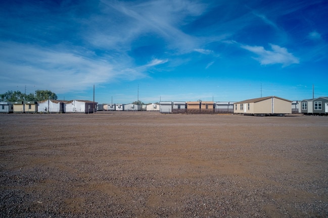
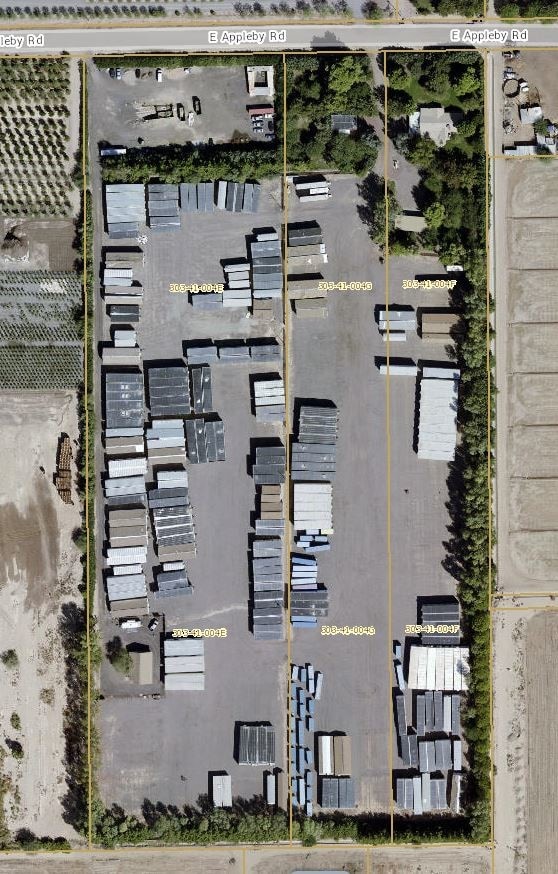
Property Detail
11541 E Appleby Rd
303-41-004F
PT W2 E2 E2 NE4 SW4 SEC 15 DAF COM CTR SD SEC 15 TH W 164.67F TO TPOB TH S 1322.85F TH W 164.86F TH N 1322.85F TH E 164.67F TPOB P/F 05-1278068 EX N 25F P/F 16-0598984
Commercialnec
Maricopa
RU43
Arizona
C and X Area of minimal flood hazard, usually depicted on FIRMs as above the 500-year flood level.
4.91 AC
2025
Chandler
2025
Phoenix
812400
Phoenix-Mesa-Chandler, AZ
2,554 SF
NEARBY LISTINGS FOR SALE OR LEASE
DEMOGRAPHICS near 11541 E Appleby Rd
1 mile
3 mile
5 mile
2025 Total Population
9,587
95,991
233,754
2030 Population
10,007
99,761
243,131
Pop Growth 2025-2030
+ 4.38%
+ 3.93%
+ 4.01%
Average Age
37
40
41
2025 Total Households
3,210
34,630
85,098
HH Growth 2025-2030
+ 4.58%
+ 4.09%
+ 4.11%
Median Household Inc
$148,432
$127,632
$112,091
Avg Household Size
2.90
2.70
2.70
2025 Avg HH Vehicles
2.00
2.00
2.00
Median Home Value
$638,163
$675,873
$587,871
Median Year Built
2009
2004
2001
Nearby Places
Map Layers
Map Styles
 Street
 Aerial
Transit
 Traffic
 Biking
Places
Listings with unknown addresses are not visible on the map
- Restaurants
- Banks
- Shops
- Fitness
- Groceries
PUBLIC TRANSPORTATION
AIRPORT
Phoenix-Mesa Gateway
Drive
Walk
Distance
Phoenix-Mesa Gateway
23 min
12.6 mi
Phoenix Sky Harbor International
Drive
Walk
Distance
Phoenix Sky Harbor International
32 min
22.5 mi
Freight Ports
Port of San Diego
Drive
Walk
Distance
Port of San Diego
398 min
363.4 mi
SALE & LEASE HISTORY
LISTING DATE
SALE/LEASE

Dec 05, 2017
For Sale
Nearby Properties
Address
Land Use
TOTAL SIZE
Lot Size
Zoning
Address
Land Use
TOTAL SIZE
Lot Size
Zoning
10.02 AC
Address
Land Use
TOTAL SIZE
Lot Size
Zoning
30,414 SF
97.19 AC
PAD
Address
Land Use
TOTAL SIZE
Lot Size
Zoning
434,857 SF
36.73 AC
PF
Address
Land Use
TOTAL SIZE
Lot Size
Zoning
1.83 AC
Address
Land Use
TOTAL SIZE
Lot Size
Zoning
288,023 SF
48.20 AC
PAD
Address
Land Use
TOTAL SIZE
Lot Size
Zoning
498,377 SF
29.12 AC
Address
Land Use
TOTAL SIZE
Lot Size
Zoning
1.64 AC
Address
Land Use
TOTAL SIZE
Lot Size
Zoning
263,599 SF
18.33 AC
PAD
Address
Land Use
TOTAL SIZE
Lot Size
Zoning
416,098 SF
22.48 AC
Address
Land Use
TOTAL SIZE
Lot Size
Zoning
363,785 SF
46.73 AC
Address
Land Use
TOTAL SIZE
Lot Size
Zoning
374,847 SF
20.84 AC
PAD
Address
Land Use
TOTAL SIZE
Lot Size
Zoning
563,460 SF
33.65 AC
Address
Land Use
TOTAL SIZE
Lot Size
Zoning
465,645 SF
30.78 AC
PAD
Address
Land Use
TOTAL SIZE
Lot Size
Zoning
444,707 SF
21.62 AC
I-2
Address
Land Use
TOTAL SIZE
Lot Size
Zoning
329,305 SF
18.06 AC
PAD
Address
Land Use
TOTAL SIZE
Lot Size
Zoning
308,238 SF
36.64 AC
PAD
Address
Land Use
TOTAL SIZE
Lot Size
Zoning
324,283 SF
18.75 AC
PAD
Address
Land Use
TOTAL SIZE
Lot Size
Zoning
180,117 SF
28.41 AC
PF
Address
Land Use
TOTAL SIZE
Lot Size
Zoning
199,808 SF
48.05 AC
PAD
Address
Land Use
TOTAL SIZE
Lot Size
Zoning
316,658 SF
47.91 AC
PAD
Address
Land Use
TOTAL SIZE
Lot Size
Zoning
325,445 SF
15.28 AC
PAD
Address
Land Use
TOTAL SIZE
Lot Size
Zoning
383,461 SF
25.76 AC
PAD
Address
Land Use
TOTAL SIZE
Lot Size
Zoning
319,061 SF
18.51 AC
PAD
Address
Land Use
TOTAL SIZE
Lot Size
Zoning
263,645 SF
17.83 AC
Address
Land Use
TOTAL SIZE
Lot Size
Zoning
78,327 SF
11.28 AC
PAD
Address
Land Use
TOTAL SIZE
Lot Size
Zoning
157,467 SF
25.91 AC
PAD
Address
Land Use
TOTAL SIZE
Lot Size
Zoning
8,307 SF
234.90 AC
AG
Address
Land Use
TOTAL SIZE
Lot Size
Zoning
220,607 SF
15.91 AC
PAD
Address
Land Use
TOTAL SIZE
Lot Size
Zoning
202,139 SF
12.08 AC
PAD
Address
Land Use
TOTAL SIZE
Lot Size
Zoning
83,457 SF
28.46 AC
PAD
The World's #1 Commercial Real Estate Marketplace
Connect with us
© 2026 CoStar Group
The information above has been obtained from sources believed reliable. While we do not doubt its accuracy we have not verified it and make no guarantee, warranty or representation about it. It is your responsibility to independently confirm its accuracy and completeness. Any projections, opinions, assumptions, or estimates used are for example only and do not represent the current or future performance of the property. The value of this transaction to you depends on tax and other factors which should be evaluated by your tax, financial, and legal advisors. You and your advisors should conduct a careful, independent investigation of the property to determine to your satisfaction the suitability of the property for your needs.