Property Record
11541 S Pulaski Rd, Alsip, IL 60803
NEARBY LISTINGS FOR SALE OR LEASE
Property Detail
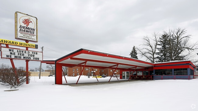
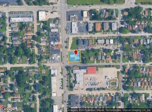
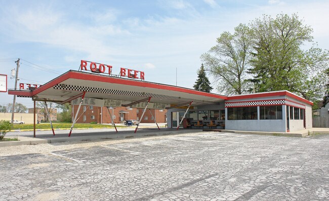
11541 S Pulaski Rd
Chicago-Naperville-Elgin, IL-IN-WI
Atwoods Add To Washington Heights
24-23-304-009-0000
(ATWOODS) ADD TO (WASHINGTON)(HEIGHTS) SUB N100ACS OF SW & N50ACS OF WH SE OF SEC 23-37-13
Commercialbuilding
Cook
X
Illinois
17031C0636K
25,26
2023
0.39 AC
2024
Near South Cook
823304
Chicago
2,562 SF
DEMOGRAPHICS near 11541 S Pulaski Rd
1 Mile
3 Mile
5 Mile
2024 Total Population
17,215
140,084
399,766
2029 Population
16,661
136,522
389,184
Pop Growth 2024-2029
(3.22%)
(2.54%)
(2.65%)
Average Age
40
41
41
2024 Total Households
6,748
54,469
147,682
HH Growth 2024-2029
(3.53%)
(2.78%)
(2.93%)
Median Household Inc
$75,443
$73,606
$66,993
Avg Household Size
2.50
2.50
2.60
2024 Avg HH Vehicles
2.00
2.00
2.00
Median Home Value
$229,619
$239,594
$214,264
Median Year Built
1961
1962
1959
Nearby Places
Map Layers
Map Styles
 Street
 Aerial
- Restaurants
- Banks
- Shops
- Fitness
- Groceries
PUBLIC TRANSPORTATION
COMMUTER RAIL
119Th Street Station (Rock Island District Line - Northeast Illinois Regional Commuter Railroad (Metra))
DRIVE
WALK
Distance
119Th Street Station (Rock Island District Line - Northeast Illinois Regional Commuter Railroad (Metra))
7 min
3.0 mi
Morgan Park - 115Th Street Station (Rock Island District Line - Northeast Illinois Regional Commuter Railroad (Metra))
DRIVE
WALK
Distance
Morgan Park - 115Th Street Station (Rock Island District Line - Northeast Illinois Regional Commuter Railroad (Metra))
7 min
3.8 mi
AIRPORT
Chicago Midway International
DRIVE
WALK
Distance
Chicago Midway International
16 min
9.3 mi
Chicago O'Hare International
DRIVE
WALK
Distance
Chicago O'Hare International
47 min
33.5 mi
Freight Ports
Port Milwaukee
DRIVE
WALK
Distance
Port Milwaukee
128 min
105.3 mi
SALE & LEASE HISTORY
LISTING DATE
SALE/LEASE

Feb 14, 2018
For Sale
Nearby Properties
Address
Land Use
TOTAL SIZE
Lot Size
Zoning
Address
Land Use
TOTAL SIZE
Lot Size
Zoning
13.59 AC
MU
Address
Land Use
TOTAL SIZE
Lot Size
Zoning
23.81 AC
Address
Land Use
TOTAL SIZE
Lot Size
Zoning
307,335 SF
24.17 AC
PD 770
Address
Land Use
TOTAL SIZE
Lot Size
Zoning
48,792 SF
8.71 AC
RT-4
Address
Land Use
TOTAL SIZE
Lot Size
Zoning
240,300 SF
3.72 AC
Address
Land Use
TOTAL SIZE
Lot Size
Zoning
63,930 SF
3.49 AC
PD 181
Address
Land Use
TOTAL SIZE
Lot Size
Zoning
495,815 SF
20.78 AC
Address
Land Use
TOTAL SIZE
Lot Size
Zoning
101,169 SF
13.07 AC
Address
Land Use
TOTAL SIZE
Lot Size
Zoning
Address
Land Use
TOTAL SIZE
Lot Size
Zoning
401,021 SF
27.42 AC
Address
Land Use
TOTAL SIZE
Lot Size
Zoning
421,052 SF
26.15 AC
Address
Land Use
TOTAL SIZE
Lot Size
Zoning
510,332 SF
23.97 AC
Address
Land Use
TOTAL SIZE
Lot Size
Zoning
149,902 SF
3.62 AC
Address
Land Use
TOTAL SIZE
Lot Size
Zoning
5.66 AC
Address
Land Use
TOTAL SIZE
Lot Size
Zoning
152,306 SF
13.40 AC
Address
Land Use
TOTAL SIZE
Lot Size
Zoning
129,837 SF
10.44 AC
PD 770
Address
Land Use
TOTAL SIZE
Lot Size
Zoning
185,748 SF
15.30 AC
Address
Land Use
TOTAL SIZE
Lot Size
Zoning
405,045 SF
14.49 AC
Address
Land Use
TOTAL SIZE
Lot Size
Zoning
113,963 SF
10.55 AC
Address
Land Use
TOTAL SIZE
Lot Size
Zoning
Address
Land Use
TOTAL SIZE
Lot Size
Zoning
869,275 SF
24.34 AC
Address
Land Use
TOTAL SIZE
Lot Size
Zoning
283,947 SF
13.27 AC
Address
Land Use
TOTAL SIZE
Lot Size
Zoning
320,038 SF
13.04 AC
Address
Land Use
TOTAL SIZE
Lot Size
Zoning
98,506 SF
7.66 AC
Address
Land Use
TOTAL SIZE
Lot Size
Zoning
100,496 SF
9.96 AC
Address
Land Use
TOTAL SIZE
Lot Size
Zoning
48,192 SF
2.01 AC
Address
Land Use
TOTAL SIZE
Lot Size
Zoning
0.15 AC
Address
Land Use
TOTAL SIZE
Lot Size
Zoning
0.15 AC
Address
Land Use
TOTAL SIZE
Lot Size
Zoning
105,150 SF
4 AC
Address
Land Use
TOTAL SIZE
Lot Size
Zoning
67,488 SF
10 AC
The World's #1 Commercial Real Estate Marketplace
Connect with us
© 2025 CoStar Group
The information above has been obtained from sources believed reliable. While we do not doubt its accuracy we have not verified it and make no guarantee, warranty or representation about it. It is your responsibility to independently confirm its accuracy and completeness. Any projections, opinions, assumptions, or estimates used are for example only and do not represent the current or future performance of the property. The value of this transaction to you depends on tax and other factors which should be evaluated by your tax, financial, and legal advisors. You and your advisors should conduct a careful, independent investigation of the property to determine to your satisfaction the suitability of the property for your needs.