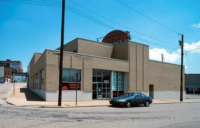
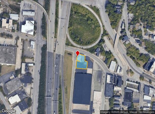
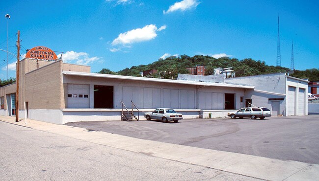
Property Record
1155 Harrison Ave, Cincinnati, OH 45214
NEARBY LISTINGS FOR SALE OR LEASE
Property Detail
1155 Harrison Ave
Cincinnati, OH-KY-IN
Harvey Coppins Sub
184-0006-0115
1155 HARRISON AVE 95 X 170 IRRPT LOTS 5-6 HARVEY COPPINS SUB PARS 115 TH 122 CONS
Warehouse
Hamilton
X
Ohio
21037C0010E
5-6
2024
0.42 AC
2024
Central/Midtown
026300
Cincinnati/Dayton
9,500 SF
DEMOGRAPHICS near 1155 Harrison Ave
1 Mile
3 Mile
5 Mile
2024 Total Population
18,738
150,892
344,022
2029 Population
18,955
153,550
347,347
Pop Growth 2024-2029
+ 1.16%
+ 1.76%
+ 0.97%
Average Age
32
35
37
2024 Total Households
7,842
67,372
150,176
HH Growth 2024-2029
+ 1.34%
+ 1.96%
+ 1.01%
Median Household Inc
$26,033
$39,533
$46,349
Avg Household Size
2.10
2.00
2.10
2024 Avg HH Vehicles
1.00
1.00
1.00
Median Home Value
$186,795
$202,146
$182,071
Median Year Built
1948
1950
1952
Nearby Places
Map Layers
Map Styles
 Street
 Aerial
- Restaurants
- Banks
- Shops
- Fitness
- Groceries
PUBLIC TRANSPORTATION
TRANSIT/SUBWAY
Brewery District Station, Elm & Henry (Streetcar - OTR - Banks - Southwest Ohio Regional Transit Authority)
DRIVE
WALK
Distance
Brewery District Station, Elm & Henry (Streetcar - OTR - Banks - Southwest Ohio Regional Transit Authority)
3 min
17 min
0.9 mi
Findlay Market-Elm Station, Elm & Glass Alley (Streetcar - OTR - Banks - Southwest Ohio Regional Transit Authority)
DRIVE
WALK
Distance
Findlay Market-Elm Station, Elm & Glass Alley (Streetcar - OTR - Banks - Southwest Ohio Regional Transit Authority)
3 min
20 min
1.1 mi
COMMUTER RAIL
Cincinnati Union Terminal (Cardinal - Amtrak)
DRIVE
WALK
Distance
Cincinnati Union Terminal (Cardinal - Amtrak)
4 min
1.4 mi
AIRPORT
Cincinnati/Northern Kentucky International
DRIVE
WALK
Distance
Cincinnati/Northern Kentucky International
29 min
15.5 mi
Freight Ports
Port of Toledo
DRIVE
WALK
Distance
Port of Toledo
240 min
204.7 mi
Nearby Properties
Address
Land Use
TOTAL SIZE
Lot Size
Zoning
Address
Land Use
TOTAL SIZE
Lot Size
Zoning
77.73 AC
IR
Address
Land Use
TOTAL SIZE
Lot Size
Zoning
6.35 AC
IR
Address
Land Use
TOTAL SIZE
Lot Size
Zoning
39.99 AC
MG
Address
Land Use
TOTAL SIZE
Lot Size
Zoning
11.82 AC
Address
Land Use
TOTAL SIZE
Lot Size
Zoning
19.36 AC
Address
Land Use
TOTAL SIZE
Lot Size
Zoning
17.10 AC
DD
Address
Land Use
TOTAL SIZE
Lot Size
Zoning
1.97 AC
DD
Address
Land Use
TOTAL SIZE
Lot Size
Zoning
11.41 AC
IR
Address
Land Use
TOTAL SIZE
Lot Size
Zoning
22.45 AC
Address
Land Use
TOTAL SIZE
Lot Size
Zoning
60,750 SF
1.52 AC
Address
Land Use
TOTAL SIZE
Lot Size
Zoning
2.60 AC
Address
Land Use
TOTAL SIZE
Lot Size
Zoning
9.55 AC
Address
Land Use
TOTAL SIZE
Lot Size
Zoning
3.09 AC
Address
Land Use
TOTAL SIZE
Lot Size
Zoning
2.80 AC
IR
Address
Land Use
TOTAL SIZE
Lot Size
Zoning
3.40 AC
IR
Address
Land Use
TOTAL SIZE
Lot Size
Zoning
89,500 SF
0.58 AC
Address
Land Use
TOTAL SIZE
Lot Size
Zoning
Address
Land Use
TOTAL SIZE
Lot Size
Zoning
290,233 SF
Address
Land Use
TOTAL SIZE
Lot Size
Zoning
3.51 AC
DD
Address
Land Use
TOTAL SIZE
Lot Size
Zoning
9,962 SF
712 AC
Address
Land Use
TOTAL SIZE
Lot Size
Zoning
Address
Land Use
TOTAL SIZE
Lot Size
Zoning
9.14 AC
Address
Land Use
TOTAL SIZE
Lot Size
Zoning
298,611 SF
Address
Land Use
TOTAL SIZE
Lot Size
Zoning
7.14 AC
Address
Land Use
TOTAL SIZE
Lot Size
Zoning
256,000 SF
Address
Land Use
TOTAL SIZE
Lot Size
Zoning
1.95 AC
Address
Land Use
TOTAL SIZE
Lot Size
Zoning
Address
Land Use
TOTAL SIZE
Lot Size
Zoning
263,300 SF
1.74 AC
Address
Land Use
TOTAL SIZE
Lot Size
Zoning
2.46 AC
Address
Land Use
TOTAL SIZE
Lot Size
Zoning
844,128 SF
1.22 AC
DD
The World's #1 Commercial Real Estate Marketplace
Connect with us
© 2025 CoStar Group
The information above has been obtained from sources believed reliable. While we do not doubt its accuracy we have not verified it and make no guarantee, warranty or representation about it. It is your responsibility to independently confirm its accuracy and completeness. Any projections, opinions, assumptions, or estimates used are for example only and do not represent the current or future performance of the property. The value of this transaction to you depends on tax and other factors which should be evaluated by your tax, financial, and legal advisors. You and your advisors should conduct a careful, independent investigation of the property to determine to your satisfaction the suitability of the property for your needs.