Property Record
116 Pawtucket Blvd, Tyngsboro, MA 01879
NEARBY LISTINGS FOR SALE OR LEASE
Property Detail
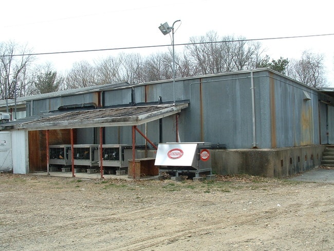
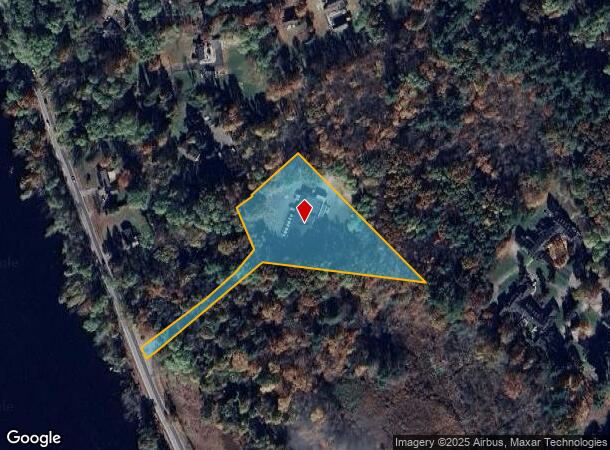
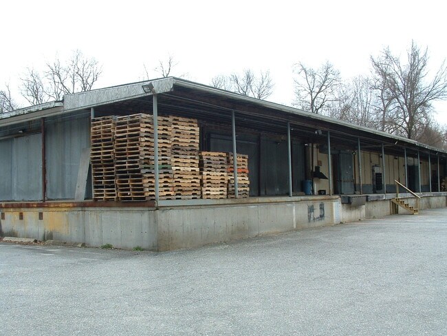
116 Pawtucket Blvd
Commercialbuilding
Middlesex
AE
Massachusetts
25017C0117F
1.90 AC
2025
Groton/Townsend
2025
Boston
313102
Boston-Cambridge-Newton, MA-NH
6,820 SF
TYNG-000027-000055
DEMOGRAPHICS near 116 Pawtucket Blvd
1 Mile
3 Mile
5 Mile
2024 Total Population
3,190
38,186
155,036
2029 Population
3,163
37,853
153,389
Pop Growth 2024-2029
(0.85%)
(0.87%)
(1.06%)
Average Age
42
42
40
2024 Total Households
1,254
14,526
57,296
HH Growth 2024-2029
(0.96%)
(1.04%)
(1.02%)
Median Household Inc
$100,818
$99,329
$86,490
Avg Household Size
2.50
2.60
2.50
2024 Avg HH Vehicles
2.00
2.00
2.00
Median Home Value
$444,612
$426,613
$428,056
Median Year Built
1991
1982
1970
Nearby Places
Map Layers
Map Styles
 Street
 Aerial
- Restaurants
- Banks
- Shops
- Fitness
- Groceries
PUBLIC TRANSPORTATION
COMMUTER RAIL
Lowell (Lowell Line - Massachusetts Bay Transportation Authority Commuter Rail (Purple Line))
DRIVE
WALK
Distance
Lowell (Lowell Line - Massachusetts Bay Transportation Authority Commuter Rail (Purple Line))
12 min
6.2 mi
AIRPORT
Manchester Boston Regional
DRIVE
WALK
Distance
Manchester Boston Regional
36 min
23.9 mi
General Edward Lawrence Logan International
DRIVE
WALK
Distance
General Edward Lawrence Logan International
56 min
40.6 mi
Freight Ports
Port of Boston
DRIVE
WALK
Distance
Port of Boston
57 min
40.3 mi
Nearby Properties
Address
Land Use
TOTAL SIZE
Lot Size
Zoning
Address
Land Use
TOTAL SIZE
Lot Size
Zoning
23,251 SF
18.20 AC
SMF
Address
Land Use
TOTAL SIZE
Lot Size
Zoning
59.09 AC
SSF
Address
Land Use
TOTAL SIZE
Lot Size
Zoning
68.15 AC
R1
Address
Land Use
TOTAL SIZE
Lot Size
Zoning
63,768 SF
8.83 AC
SMU
Address
Land Use
TOTAL SIZE
Lot Size
Zoning
33.01 AC
R3
Address
Land Use
TOTAL SIZE
Lot Size
Zoning
44.39 AC
SMU
Address
Land Use
TOTAL SIZE
Lot Size
Zoning
199.97 AC
B2
Address
Land Use
TOTAL SIZE
Lot Size
Zoning
45.10 AC
R1
Address
Land Use
TOTAL SIZE
Lot Size
Zoning
8.30 AC
B3
Address
Land Use
TOTAL SIZE
Lot Size
Zoning
135,324 SF
70.07 AC
R1
Address
Land Use
TOTAL SIZE
Lot Size
Zoning
90,463 SF
8.56 AC
RA
Address
Land Use
TOTAL SIZE
Lot Size
Zoning
177.27 AC
R1
Address
Land Use
TOTAL SIZE
Lot Size
Zoning
2.71 AC
SMF
Address
Land Use
TOTAL SIZE
Lot Size
Zoning
12.26 AC
P
Address
Land Use
TOTAL SIZE
Lot Size
Zoning
31.92 AC
RB
Address
Land Use
TOTAL SIZE
Lot Size
Zoning
91,202 SF
12.65 AC
SMU
Address
Land Use
TOTAL SIZE
Lot Size
Zoning
4.33 AC
R3
Address
Land Use
TOTAL SIZE
Lot Size
Zoning
42,419 SF
2.80 AC
SSF
Address
Land Use
TOTAL SIZE
Lot Size
Zoning
50,000 SF
33.40 AC
IA
Address
Land Use
TOTAL SIZE
Lot Size
Zoning
8.20 AC
SSF
Address
Land Use
TOTAL SIZE
Lot Size
Zoning
71,911 SF
31.55 AC
SSF
Address
Land Use
TOTAL SIZE
Lot Size
Zoning
15.86 AC
B3
Address
Land Use
TOTAL SIZE
Lot Size
Zoning
3.77 AC
B3
Address
Land Use
TOTAL SIZE
Lot Size
Zoning
1.66 AC
SMF
Address
Land Use
TOTAL SIZE
Lot Size
Zoning
8.30 AC
R1
Address
Land Use
TOTAL SIZE
Lot Size
Zoning
576 SF
19.97 AC
SMU
Address
Land Use
TOTAL SIZE
Lot Size
Zoning
9.92 AC
SSF
Address
Land Use
TOTAL SIZE
Lot Size
Zoning
17.86 AC
I1
Address
Land Use
TOTAL SIZE
Lot Size
Zoning
1.38 AC
SMF
Address
Land Use
TOTAL SIZE
Lot Size
Zoning
63,138 SF
0.68 AC
I1
The World's #1 Commercial Real Estate Marketplace
Connect with us
© 2025 CoStar Group
The information above has been obtained from sources believed reliable. While we do not doubt its accuracy we have not verified it and make no guarantee, warranty or representation about it. It is your responsibility to independently confirm its accuracy and completeness. Any projections, opinions, assumptions, or estimates used are for example only and do not represent the current or future performance of the property. The value of this transaction to you depends on tax and other factors which should be evaluated by your tax, financial, and legal advisors. You and your advisors should conduct a careful, independent investigation of the property to determine to your satisfaction the suitability of the property for your needs.