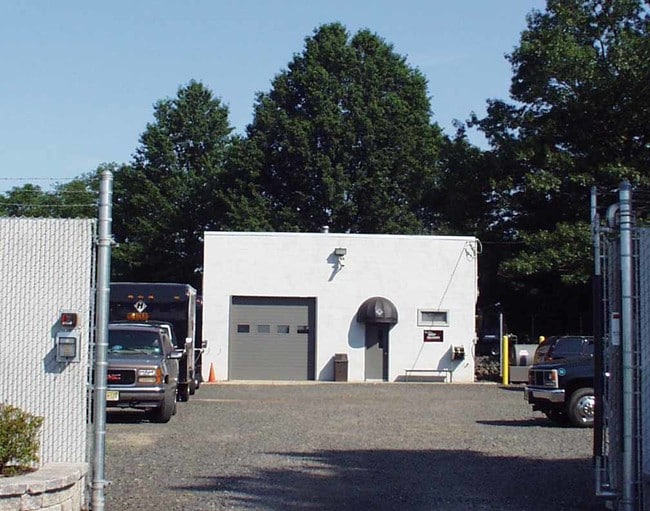
Property Record
1160 Us Highway 202 S, Branchburg, NJ 08876

NEARBY LISTINGS FOR SALE OR LEASE
Property Detail
1160 Us Highway 202 S
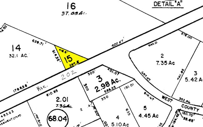
05-00061-0000-00015
ADDITIONAL LOTS: 2734+1980
Officebuilding
Somerset
X
New Jersey
34035C0137E
15
2024
1.02 AC
2025
Princeton North
053602
Northern New Jersey
3,312 SF
Newark, NJ-PA
DEMOGRAPHICS near 1160 Us Highway 202 S
1 Mile
3 Mile
5 Mile
2024 Total Population
2,807
24,140
74,442
2029 Population
2,769
24,004
74,593
Pop Growth 2024-2029
(1.35%)
(0.56%)
+ 0.20%
Average Age
43
43
42
2024 Total Households
1,059
8,929
27,524
HH Growth 2024-2029
(1.42%)
(0.62%)
+ 0.21%
Median Household Inc
$168,518
$155,803
$138,460
Avg Household Size
2.60
2.70
2.60
2024 Avg HH Vehicles
2.00
2.00
2.00
Median Home Value
$532,967
$502,694
$478,543
Median Year Built
1983
1985
1983
Nearby Places
Map Layers
Map Styles
 Street
 Aerial
- Restaurants
- Banks
- Shops
- Fitness
- Groceries
PUBLIC TRANSPORTATION
COMMUTER RAIL
North Branch (Raritan Valley Line - NJ Transit Commuter Rail (NJ Transit))
DRIVE
WALK
Distance
North Branch (Raritan Valley Line - NJ Transit Commuter Rail (NJ Transit))
12 min
5.0 mi
Raritan (Raritan Valley Line - NJ Transit Commuter Rail (NJ Transit))
DRIVE
WALK
Distance
Raritan (Raritan Valley Line - NJ Transit Commuter Rail (NJ Transit))
10 min
6.1 mi
AIRPORT
Trenton Mercer
DRIVE
WALK
Distance
Trenton Mercer
46 min
27.0 mi
Newark Liberty International
DRIVE
WALK
Distance
Newark Liberty International
51 min
40.2 mi
Freight Ports
New York Container Terminal
DRIVE
WALK
Distance
New York Container Terminal
52 min
39.3 mi
Nearby Properties
Address
Land Use
TOTAL SIZE
Lot Size
Zoning
Address
Land Use
TOTAL SIZE
Lot Size
Zoning
63.86 AC
I2
Address
Land Use
TOTAL SIZE
Lot Size
Zoning
29.74 AC
I-2
Address
Land Use
TOTAL SIZE
Lot Size
Zoning
47.50 AC
M1
Address
Land Use
TOTAL SIZE
Lot Size
Zoning
28.76 AC
I-IP
Address
Land Use
TOTAL SIZE
Lot Size
Zoning
54.31 AC
P-2
Address
Land Use
TOTAL SIZE
Lot Size
Zoning
24.04 AC
RMU
Address
Land Use
TOTAL SIZE
Lot Size
Zoning
10.33 AC
I-2
Address
Land Use
TOTAL SIZE
Lot Size
Zoning
12.58 AC
I-2
Address
Land Use
TOTAL SIZE
Lot Size
Zoning
38.79 AC
I-1
Address
Land Use
TOTAL SIZE
Lot Size
Zoning
20.18 AC
I-1
Address
Land Use
TOTAL SIZE
Lot Size
Zoning
25.25 AC
I2
Address
Land Use
TOTAL SIZE
Lot Size
Zoning
23.11 AC
I-1
Address
Land Use
TOTAL SIZE
Lot Size
Zoning
22.84 AC
I-1
Address
Land Use
TOTAL SIZE
Lot Size
Zoning
12.15 AC
I-2
Address
Land Use
TOTAL SIZE
Lot Size
Zoning
1,356 SF
5.05 AC
RS2
Address
Land Use
TOTAL SIZE
Lot Size
Zoning
18,288 SF
3.78 AC
I-IP
Address
Land Use
TOTAL SIZE
Lot Size
Zoning
8.69 AC
I-2
Address
Land Use
TOTAL SIZE
Lot Size
Zoning
12.83 AC
I-1
Address
Land Use
TOTAL SIZE
Lot Size
Zoning
1,987 SF
3.17 AC
RS2
Address
Land Use
TOTAL SIZE
Lot Size
Zoning
5.98 AC
I-2
Address
Land Use
TOTAL SIZE
Lot Size
Zoning
58.40 AC
M1
Address
Land Use
TOTAL SIZE
Lot Size
Zoning
8.30 AC
I
Address
Land Use
TOTAL SIZE
Lot Size
Zoning
4.90 AC
I2
Address
Land Use
TOTAL SIZE
Lot Size
Zoning
8.51 AC
S1
Address
Land Use
TOTAL SIZE
Lot Size
Zoning
6.32 AC
I-IP
Address
Land Use
TOTAL SIZE
Lot Size
Zoning
4.50 AC
P-2
Address
Land Use
TOTAL SIZE
Lot Size
Zoning
8.40 AC
I&IP
Address
Land Use
TOTAL SIZE
Lot Size
Zoning
9.02 AC
CF
Address
Land Use
TOTAL SIZE
Lot Size
Zoning
10.82 AC
CF
Address
Land Use
TOTAL SIZE
Lot Size
Zoning
9.54 AC
I-IP
The World's #1 Commercial Real Estate Marketplace
Connect with us
© 2025 CoStar Group
The information above has been obtained from sources believed reliable. While we do not doubt its accuracy we have not verified it and make no guarantee, warranty or representation about it. It is your responsibility to independently confirm its accuracy and completeness. Any projections, opinions, assumptions, or estimates used are for example only and do not represent the current or future performance of the property. The value of this transaction to you depends on tax and other factors which should be evaluated by your tax, financial, and legal advisors. You and your advisors should conduct a careful, independent investigation of the property to determine to your satisfaction the suitability of the property for your needs.