Property Record
11603 Interstate 10 E, Baytown, TX 77523
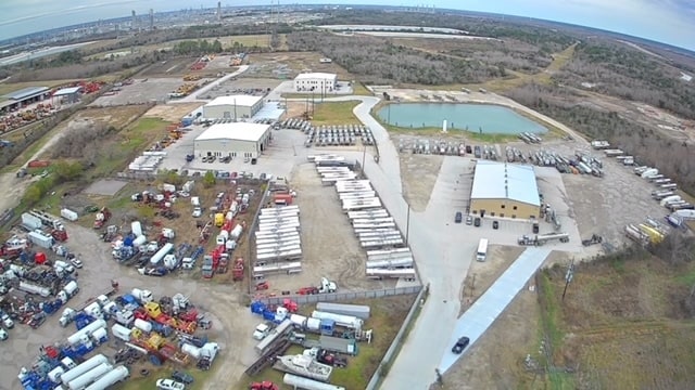
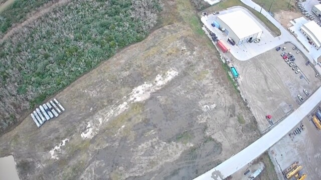
Property Detail
11603 Interstate 10 E
00321-03400-00100-090300
321 TR 40-2 C C SCHOOL
Industrialgeneral
CHAMBERS
B and X Area of moderate flood hazard, usually the area between the limits of the 100-year and 500-year floods.
Texas
2025
10.72 AC
2025
Northeast Outlier
710100
Houston
8,000 SF
Houston-Pasadena-The Woodlands, TX
NEARBY LISTINGS FOR SALE OR LEASE
DEMOGRAPHICS near 11603 Interstate 10 E
1 mile
3 mile
5 mile
2024 Total Population
512
21,625
49,426
2029 Population
771
32,495
71,648
Pop Growth 2024-2029
+ 50.59%
+ 50.27%
+ 44.96%
Average Age
34
35
36
2024 Total Households
160
6,861
15,959
HH Growth 2024-2029
+ 51.25%
+ 50.53%
+ 45.10%
Median Household Inc
$119,317
$118,011
$117,780
Avg Household Size
3.20
3.20
3.10
2024 Avg HH Vehicles
2.00
2.00
2.00
Median Home Value
$339,062
$313,588
$321,031
Median Year Built
2010
2010
2009
Nearby Places
Map Layers
Map Styles
 Street
 Aerial
Transit
 Traffic
 Biking
Places
Listings with unknown addresses are not visible on the map
- Restaurants
- Banks
- Shops
- Fitness
- Groceries
PUBLIC TRANSPORTATION
AIRPORT
William P Hobby
Drive
Walk
Distance
William P Hobby
52 min
35.8 mi
George Bush Intcntl/Houston
Drive
Walk
Distance
George Bush Intcntl/Houston
49 min
39.9 mi
Freight Ports
Port of Houston
Drive
Walk
Distance
Port of Houston
39 min
27.8 mi
SALE & LEASE HISTORY
LISTING DATE
SALE/LEASE

Sep 26, 2018
For Sale
Feb 01, 2025
For Sale
Nearby Properties
Address
Land Use
TOTAL SIZE
Lot Size
Zoning
Address
Land Use
TOTAL SIZE
Lot Size
Zoning
0.58 AC
Address
Land Use
TOTAL SIZE
Lot Size
Zoning
63,224 SF
738.31 AC
Address
Land Use
TOTAL SIZE
Lot Size
Zoning
738.47 AC
Address
Land Use
TOTAL SIZE
Lot Size
Zoning
463.62 AC
Address
Land Use
TOTAL SIZE
Lot Size
Zoning
738.31 AC
Address
Land Use
TOTAL SIZE
Lot Size
Zoning
Address
Land Use
TOTAL SIZE
Lot Size
Zoning
Address
Land Use
TOTAL SIZE
Lot Size
Zoning
738.47 AC
Address
Land Use
TOTAL SIZE
Lot Size
Zoning
194,400 SF
53.79 AC
Address
Land Use
TOTAL SIZE
Lot Size
Zoning
133,873 SF
12.26 AC
Address
Land Use
TOTAL SIZE
Lot Size
Zoning
22,375 SF
12.13 AC
Address
Land Use
TOTAL SIZE
Lot Size
Zoning
58,493 SF
18.49 AC
Address
Land Use
TOTAL SIZE
Lot Size
Zoning
738.47 AC
Address
Land Use
TOTAL SIZE
Lot Size
Zoning
11,189 SF
7.40 AC
Address
Land Use
TOTAL SIZE
Lot Size
Zoning
3,900 SF
42.94 AC
Address
Land Use
TOTAL SIZE
Lot Size
Zoning
13,927 SF
23.39 AC
Address
Land Use
TOTAL SIZE
Lot Size
Zoning
9,087 SF
6.98 AC
Address
Land Use
TOTAL SIZE
Lot Size
Zoning
222,375 SF
42.92 AC
Address
Land Use
TOTAL SIZE
Lot Size
Zoning
34,504 SF
9.19 AC
Address
Land Use
TOTAL SIZE
Lot Size
Zoning
42.79 AC
Address
Land Use
TOTAL SIZE
Lot Size
Zoning
187,383 SF
18.95 AC
Address
Land Use
TOTAL SIZE
Lot Size
Zoning
9,627 SF
6.91 AC
Address
Land Use
TOTAL SIZE
Lot Size
Zoning
2,239 SF
9.15 AC
Address
Land Use
TOTAL SIZE
Lot Size
Zoning
46.88 AC
Address
Land Use
TOTAL SIZE
Lot Size
Zoning
21,000 SF
51.28 AC
Address
Land Use
TOTAL SIZE
Lot Size
Zoning
68.73 AC
Address
Land Use
TOTAL SIZE
Lot Size
Zoning
24.90 AC
Address
Land Use
TOTAL SIZE
Lot Size
Zoning
34.88 AC
Address
Land Use
TOTAL SIZE
Lot Size
Zoning
86,209 SF
13.40 AC
The World's #1 Commercial Real Estate Marketplace
Connect with us
© 2026 CoStar Group
The information above has been obtained from sources believed reliable. While we do not doubt its accuracy we have not verified it and make no guarantee, warranty or representation about it. It is your responsibility to independently confirm its accuracy and completeness. Any projections, opinions, assumptions, or estimates used are for example only and do not represent the current or future performance of the property. The value of this transaction to you depends on tax and other factors which should be evaluated by your tax, financial, and legal advisors. You and your advisors should conduct a careful, independent investigation of the property to determine to your satisfaction the suitability of the property for your needs.