Property Record
1164 Burris Blvd, Lincolnton, NC 28092


Save to a Folder
{{folder.Name}}
{{folder.ListingIds.length}} Properties
{{folder.ListingIds.length}} Property
Create a New Folder
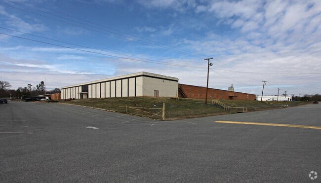
Property Detail
1164 Burris Blvd
01332
PLANT #2 RD 1449
Manufacturinglight
Lincoln
GMC
North Carolina
B and X Area of moderate flood hazard, usually the area between the limits of the 100-year and 500-year floods.
37.47 AC
2025
Lincoln County
2025
Charlotte
070400
Charlotte-Concord-Gastonia, NC-SC
361,982 SF
NEARBY LISTINGS FOR SALE OR LEASE
DEMOGRAPHICS near 1164 Burris Blvd
1 mile
3 mile
5 mile
2025 Total Population
2,490
15,352
32,119
2030 Population
2,762
16,907
35,211
Pop Growth 2025-2030
+ 10.92%
+ 10.13%
+ 9.63%
Average Age
42
43
42
2025 Total Households
1,076
6,414
13,073
HH Growth 2025-2030
+ 11.06%
+ 10.21%
+ 9.72%
Median Household Inc
$38,509
$53,856
$58,036
Avg Household Size
2.30
2.30
2.40
2025 Avg HH Vehicles
2.00
2.00
2.00
Median Home Value
$171,428
$282,685
$278,716
Median Year Built
1966
1978
1984
Nearby Places
Map Layers
Map Styles
 Street
 Aerial
Layers
 Traffic
 Biking
Places
Listings with unknown addresses are not visible on the map
- Restaurants
- Banks
- Shops
- Fitness
- Groceries
PUBLIC TRANSPORTATION
AIRPORT
Charlotte/Douglas International
Drive
Walk
Distance
Charlotte/Douglas International
53 min
32.6 mi
Concord-Padgett Regional
Drive
Walk
Distance
Concord-Padgett Regional
65 min
42.9 mi
SALE & LEASE HISTORY
LISTING DATE
SALE/LEASE

Jan 15, 2021
For Lease
Nearby Properties
Address
Land Use
TOTAL SIZE
Lot Size
Zoning
Address
Land Use
TOTAL SIZE
Lot Size
Zoning
88,878 SF
7.21 AC
O-I
Address
Land Use
TOTAL SIZE
Lot Size
Zoning
99,626 SF
21.55 AC
R-SF
Address
Land Use
TOTAL SIZE
Lot Size
Zoning
322,560 SF
132.94 AC
I-G
Address
Land Use
TOTAL SIZE
Lot Size
Zoning
118,694 SF
25.90 AC
R-10
Address
Land Use
TOTAL SIZE
Lot Size
Zoning
45,354 SF
50.76 AC
R-10
Address
Land Use
TOTAL SIZE
Lot Size
Zoning
53,152 SF
3.97 AC
G-B CD
Address
Land Use
TOTAL SIZE
Lot Size
Zoning
189,220 SF
23.64 AC
P-B CU
Address
Land Use
TOTAL SIZE
Lot Size
Zoning
1,488 SF
10.65 AC
O-I CU
Address
Land Use
TOTAL SIZE
Lot Size
Zoning
10,120 SF
23.38 AC
G-B & P-B
Address
Land Use
TOTAL SIZE
Lot Size
Zoning
42,405 SF
34.47 AC
GMC
Address
Land Use
TOTAL SIZE
Lot Size
Zoning
2,047 SF
46.35 AC
RMF
Address
Land Use
TOTAL SIZE
Lot Size
Zoning
39,860 SF
3.71 AC
O-I
Address
Land Use
TOTAL SIZE
Lot Size
Zoning
4,475 SF
14.98 AC
R-15
Address
Land Use
TOTAL SIZE
Lot Size
Zoning
8,770 SF
11.21 AC
P-B
Address
Land Use
TOTAL SIZE
Lot Size
Zoning
52,000 SF
10.06 AC
O-I
Address
Land Use
TOTAL SIZE
Lot Size
Zoning
120,810 SF
16.90 AC
G-B CU
Address
Land Use
TOTAL SIZE
Lot Size
Zoning
66,527 SF
2.10 AC
R-15
Address
Land Use
TOTAL SIZE
Lot Size
Zoning
125,620 SF
16.65 AC
I-G
Address
Land Use
TOTAL SIZE
Lot Size
Zoning
220,297 SF
41.47 AC
I-G
Address
Land Use
TOTAL SIZE
Lot Size
Zoning
40,203 SF
3.37 AC
P-B
Address
Land Use
TOTAL SIZE
Lot Size
Zoning
144,596 SF
11.45 AC
I-G
Address
Land Use
TOTAL SIZE
Lot Size
Zoning
41,016 SF
4 AC
G-B
Address
Land Use
TOTAL SIZE
Lot Size
Zoning
42,882 SF
10.52 AC
P-B
Address
Land Use
TOTAL SIZE
Lot Size
Zoning
63,404 SF
26 AC
GMC
Address
Land Use
TOTAL SIZE
Lot Size
Zoning
36,100 SF
3.38 AC
R-8
Address
Land Use
TOTAL SIZE
Lot Size
Zoning
522,930 SF
25.71 AC
GMC & O-I
Address
Land Use
TOTAL SIZE
Lot Size
Zoning
39,474 SF
1.39 AC
C-B
Address
Land Use
TOTAL SIZE
Lot Size
Zoning
132,221 SF
7.16 AC
P-B
Address
Land Use
TOTAL SIZE
Lot Size
Zoning
41,025 SF
23.14 AC
R-15
Address
Land Use
TOTAL SIZE
Lot Size
Zoning
59,178 SF
13.65 AC
R-25
The World's #1 Commercial Real Estate Marketplace
Connect with us
© 2026 CoStar Group
The information above has been obtained from sources believed reliable. While we do not doubt its accuracy we have not verified it and make no guarantee, warranty or representation about it. It is your responsibility to independently confirm its accuracy and completeness. Any projections, opinions, assumptions, or estimates used are for example only and do not represent the current or future performance of the property. The value of this transaction to you depends on tax and other factors which should be evaluated by your tax, financial, and legal advisors. You and your advisors should conduct a careful, independent investigation of the property to determine to your satisfaction the suitability of the property for your needs.