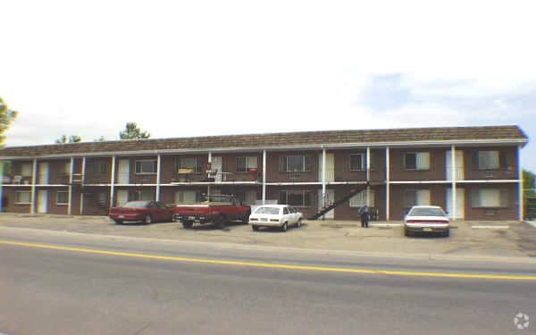
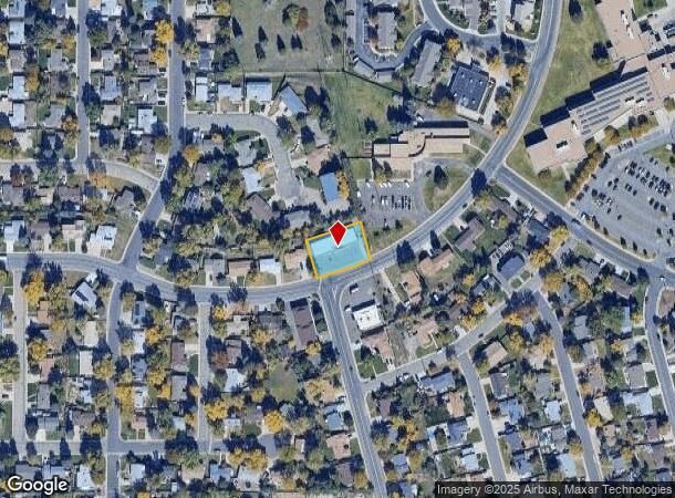
Property Record
11677 W 62Nd Ave, Arvada, CO 80004
NEARBY LISTINGS FOR SALE OR LEASE
Property Detail
11677 W 62Nd Ave
Denver-Aurora-Centennial, CO
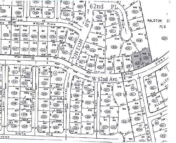
Allendale 12Th Flg
39-081-01-033
SECTION 08 TOWNSHIP 03 RANGE 69 QTR NE SUBDIVISIONCD 016400 SUBDIVISIONNAME ALLENDALE 12TH FLG BLOCK LOT 1028 SIZE: 8930 TRACT VALUE: .205 SECTION 08 TOWNSHIP 03 RANGE 69 QTR NE SUBDIVISIONCD 016400 SUBDIVISIONNAME ALLENDALE 12TH FLG BLOCK LOT 1029 S
Multifamilydwelling
Jefferson
X
Colorado
08059C0192F
1028
2023
0.39 AC
2024
Allendale Area
010306
Denver
8,568 SF
DEMOGRAPHICS near 11677 W 62Nd Ave
1 Mile
3 Mile
5 Mile
2024 Total Population
15,308
91,955
218,144
2029 Population
15,171
91,026
216,481
Pop Growth 2024-2029
(0.89%)
(1.01%)
(0.76%)
Average Age
43
42
42
2024 Total Households
6,251
38,061
89,648
HH Growth 2024-2029
(1.01%)
(1.07%)
(0.80%)
Median Household Inc
$92,665
$96,105
$92,418
Avg Household Size
2.40
2.40
2.40
2024 Avg HH Vehicles
2.00
2.00
2.00
Median Home Value
$519,985
$589,836
$557,485
Median Year Built
1976
1977
1976
Nearby Places
Map Layers
Map Styles
 Street
 Aerial
- Restaurants
- Banks
- Shops
- Fitness
- Groceries
PUBLIC TRANSPORTATION
AIRPORT
Denver International
DRIVE
WALK
Distance
Denver International
42 min
31.5 mi
Nearby Properties
Address
Land Use
TOTAL SIZE
Lot Size
Zoning
Address
Land Use
TOTAL SIZE
Lot Size
Zoning
830,160 SF
26.93 AC
Address
Land Use
TOTAL SIZE
Lot Size
Zoning
269,013 SF
31.89 AC
Address
Land Use
TOTAL SIZE
Lot Size
Zoning
253,643 SF
50.87 AC
A2
Address
Land Use
TOTAL SIZE
Lot Size
Zoning
365,230 SF
12.51 AC
Address
Land Use
TOTAL SIZE
Lot Size
Zoning
389,561 SF
10.73 AC
Address
Land Use
TOTAL SIZE
Lot Size
Zoning
215,878 SF
11.82 AC
A2
Address
Land Use
TOTAL SIZE
Lot Size
Zoning
131,135 SF
2.83 AC
Address
Land Use
TOTAL SIZE
Lot Size
Zoning
262,699 SF
13.10 AC
A2
Address
Land Use
TOTAL SIZE
Lot Size
Zoning
363,989 SF
30.10 AC
Address
Land Use
TOTAL SIZE
Lot Size
Zoning
101,761 SF
4.34 AC
Address
Land Use
TOTAL SIZE
Lot Size
Zoning
142,200 SF
9.82 AC
Address
Land Use
TOTAL SIZE
Lot Size
Zoning
520,896 SF
24.42 AC
I1
Address
Land Use
TOTAL SIZE
Lot Size
Zoning
149,115 SF
18 AC
Address
Land Use
TOTAL SIZE
Lot Size
Zoning
91,734 SF
9.69 AC
Address
Land Use
TOTAL SIZE
Lot Size
Zoning
130,662 SF
9.67 AC
Address
Land Use
TOTAL SIZE
Lot Size
Zoning
223,338 SF
9.42 AC
I1
Address
Land Use
TOTAL SIZE
Lot Size
Zoning
82,055 SF
19.39 AC
Address
Land Use
TOTAL SIZE
Lot Size
Zoning
78,494 SF
5.68 AC
Address
Land Use
TOTAL SIZE
Lot Size
Zoning
68,300 SF
6 AC
Address
Land Use
TOTAL SIZE
Lot Size
Zoning
174,853 SF
14.68 AC
Address
Land Use
TOTAL SIZE
Lot Size
Zoning
169,525 SF
2.93 AC
Address
Land Use
TOTAL SIZE
Lot Size
Zoning
67,520 SF
6.46 AC
Address
Land Use
TOTAL SIZE
Lot Size
Zoning
51,987 SF
15.23 AC
PD
Address
Land Use
TOTAL SIZE
Lot Size
Zoning
83,684 SF
8.15 AC
Address
Land Use
TOTAL SIZE
Lot Size
Zoning
150,321 SF
6.52 AC
Address
Land Use
TOTAL SIZE
Lot Size
Zoning
224,923 SF
33.71 AC
Address
Land Use
TOTAL SIZE
Lot Size
Zoning
201,582 SF
5.78 AC
Address
Land Use
TOTAL SIZE
Lot Size
Zoning
22,524 SF
3.74 AC
Address
Land Use
TOTAL SIZE
Lot Size
Zoning
265,676 SF
2.03 AC
Address
Land Use
TOTAL SIZE
Lot Size
Zoning
67,879 SF
9.91 AC
A2
The World's #1 Commercial Real Estate Marketplace
Connect with us
© 2026 CoStar Group
The information above has been obtained from sources believed reliable. While we do not doubt its accuracy we have not verified it and make no guarantee, warranty or representation about it. It is your responsibility to independently confirm its accuracy and completeness. Any projections, opinions, assumptions, or estimates used are for example only and do not represent the current or future performance of the property. The value of this transaction to you depends on tax and other factors which should be evaluated by your tax, financial, and legal advisors. You and your advisors should conduct a careful, independent investigation of the property to determine to your satisfaction the suitability of the property for your needs.