Property Record
11680 Hayden Rd, Manassas, VA 20109
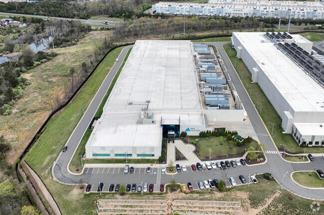

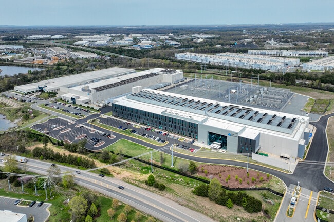
Property Detail
11680 Hayden Rd
7596-47-5780
PCL A2
Datacentre
Prince William
M2
Virginia
AE The base floodplain where base flood elevations are provided. AE Zones are now used on new format FIRMs instead of A1-A30 Zones.
12 AC
2024
Rt 29/I-66 Corridor
2025
Washington, DC
901409
Washington-Arlington-Alexandria, DC-VA-MD-WV
165,230 SF
NEARBY LISTINGS FOR SALE OR LEASE
DEMOGRAPHICS near 11680 Hayden Rd
1 mile
3 mile
5 mile
2025 Total Population
5,725
68,847
164,519
2030 Population
5,874
70,688
168,311
Pop Growth 2025-2030
+ 2.60%
+ 2.67%
+ 2.30%
Average Age
35
35
37
2025 Total Households
2,063
21,920
51,327
HH Growth 2025-2030
+ 2.52%
+ 2.66%
+ 2.34%
Median Household Inc
$133,540
$113,395
$123,833
Avg Household Size
2.70
3.10
3.10
2025 Avg HH Vehicles
2.00
2.00
2.00
Median Home Value
$577,356
$497,844
$524,822
Median Year Built
2004
1994
1994
Nearby Places
Map Layers
Map Styles
 Street
 Aerial
Layers
 Traffic
 Biking
Places
Listings with unknown addresses are not visible on the map
- Restaurants
- Banks
- Shops
- Fitness
- Groceries
PUBLIC TRANSPORTATION
COMMUTER RAIL
Drive
Walk
Distance
13 min
5.0 mi
Drive
Walk
Distance
13 min
5.3 mi
AIRPORT
Washington Dulles International
Drive
Walk
Distance
Washington Dulles International
37 min
21.8 mi
Ronald Reagan Washington Ntl
Drive
Walk
Distance
Ronald Reagan Washington Ntl
51 min
36.4 mi
Nearby Properties
Address
Land Use
TOTAL SIZE
Lot Size
Zoning
Address
Land Use
TOTAL SIZE
Lot Size
Zoning
866,820 SF
253.92 AC
M2
Address
Land Use
TOTAL SIZE
Lot Size
Zoning
482,223 SF
28.10 AC
PBD
Address
Land Use
TOTAL SIZE
Lot Size
Zoning
389,649 SF
11.82 AC
M2
Address
Land Use
TOTAL SIZE
Lot Size
Zoning
233,757 SF
15.54 AC
PBD
Address
Land Use
TOTAL SIZE
Lot Size
Zoning
223,757 SF
15.92 AC
PBD
Address
Land Use
TOTAL SIZE
Lot Size
Zoning
216,067 SF
15.85 AC
PBD
Address
Land Use
TOTAL SIZE
Lot Size
Zoning
213,320 SF
31.06 AC
PBD
Address
Land Use
TOTAL SIZE
Lot Size
Zoning
305,510 SF
22.72 AC
M2
Address
Land Use
TOTAL SIZE
Lot Size
Zoning
269,091 SF
32.31 AC
M2
Address
Land Use
TOTAL SIZE
Lot Size
Zoning
224,652 SF
12.05 AC
PBD
Address
Land Use
TOTAL SIZE
Lot Size
Zoning
241,249 SF
12.58 AC
PBD
Address
Land Use
TOTAL SIZE
Lot Size
Zoning
325,918 SF
41.38 AC
M2
Address
Land Use
TOTAL SIZE
Lot Size
Zoning
281,000 SF
10.08 AC
PBD
Address
Land Use
TOTAL SIZE
Lot Size
Zoning
259,200 SF
14.22 AC
PBD
Address
Land Use
TOTAL SIZE
Lot Size
Zoning
181.29 AC
M1
Address
Land Use
TOTAL SIZE
Lot Size
Zoning
230,706 SF
13.94 AC
PMD
Address
Land Use
TOTAL SIZE
Lot Size
Zoning
117.22 AC
M1
Address
Land Use
TOTAL SIZE
Lot Size
Zoning
719,742 SF
62.13 AC
M2
Address
Land Use
TOTAL SIZE
Lot Size
Zoning
656,797 SF
Address
Land Use
TOTAL SIZE
Lot Size
Zoning
115,600 SF
10.06 AC
M1
Address
Land Use
TOTAL SIZE
Lot Size
Zoning
123,534 SF
7.85 AC
M1
Address
Land Use
TOTAL SIZE
Lot Size
Zoning
824,085 SF
120.07 AC
MIXED
Address
Land Use
TOTAL SIZE
Lot Size
Zoning
112.48 AC
M2
Address
Land Use
TOTAL SIZE
Lot Size
Zoning
247,608 SF
19.50 AC
PBD
Address
Land Use
TOTAL SIZE
Lot Size
Zoning
127,000 SF
12.40 AC
M2
Address
Land Use
TOTAL SIZE
Lot Size
Zoning
312,931 SF
83 AC
M2
Address
Land Use
TOTAL SIZE
Lot Size
Zoning
127,700 SF
7.92 AC
M1
Address
Land Use
TOTAL SIZE
Lot Size
Zoning
409,252 SF
18.75 AC
M2
Address
Land Use
TOTAL SIZE
Lot Size
Zoning
258,716 SF
58.54 AC
M1
The World's #1 Commercial Real Estate Marketplace
Connect with us
© 2026 CoStar Group
The information above has been obtained from sources believed reliable. While we do not doubt its accuracy we have not verified it and make no guarantee, warranty or representation about it. It is your responsibility to independently confirm its accuracy and completeness. Any projections, opinions, assumptions, or estimates used are for example only and do not represent the current or future performance of the property. The value of this transaction to you depends on tax and other factors which should be evaluated by your tax, financial, and legal advisors. You and your advisors should conduct a careful, independent investigation of the property to determine to your satisfaction the suitability of the property for your needs.