Property Record
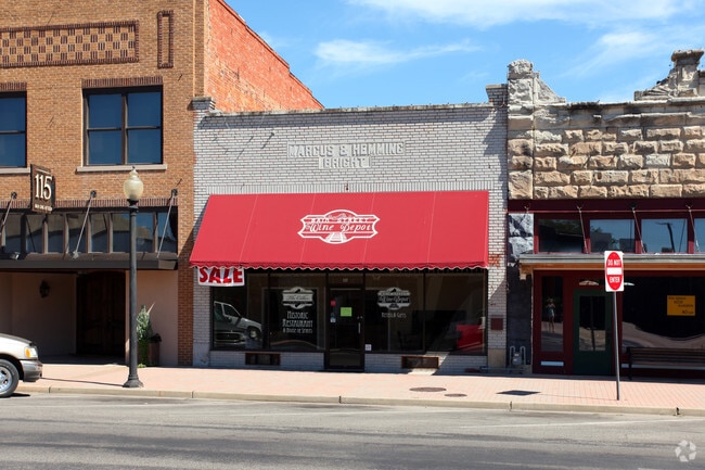
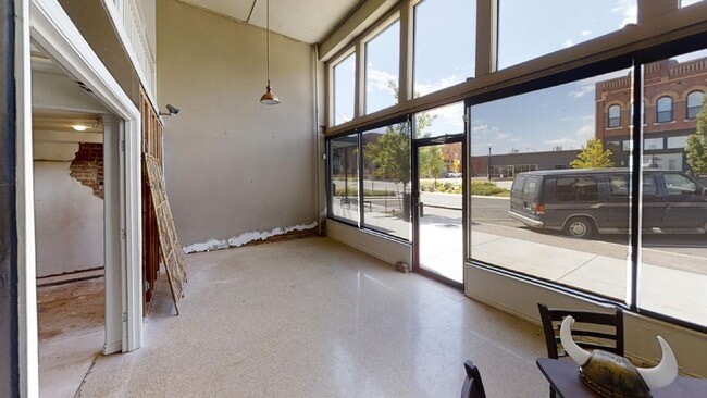
117 E Main St, Ardmore, OK 73401

Property Detail
117 E Main St
0010-00-323-012-0-001-00
ARDMORE LOTS & BLKS, BLK 323 LOT 12 (25X192X25X192)
Farmsupplyequipmentretail
Carter
C1
Oklahoma
B and X Area of moderate flood hazard, usually the area between the limits of the 100-year and 500-year floods.
12
2025
0.11 AC
2025
Oklahoma East Area
892900
Other Market Areas
1,675 SF
Ardmore, OK
NEARBY LISTINGS FOR SALE OR LEASE
-
-
-
-
No Photo
-
-
-
-
View all Ardmore listings for sale on LoopNet.com
DEMOGRAPHICS near 117 E Main St
1 mile
3 mile
5 mile
2025 Total Population
8,225
23,965
28,999
2030 Population
8,501
24,565
29,696
Pop Growth 2025-2030
+ 3.36%
+ 2.50%
+ 2.40%
Average Age
39
41
41
2025 Total Households
3,253
9,685
11,589
HH Growth 2025-2030
+ 3.32%
+ 2.46%
+ 2.38%
Median Household Inc
$41,941
$50,346
$54,900
Avg Household Size
2.30
2.30
2.40
2025 Avg HH Vehicles
2.00
2.00
2.00
Median Home Value
$109,533
$167,960
$184,634
Median Year Built
1953
1966
1971
Nearby Places
Map Layers
Map Styles
 Street
 Aerial
Layers
 Traffic
 Biking
Places
Listings with unknown addresses are not visible on the map
- Restaurants
- Banks
- Shops
- Fitness
- Groceries
PUBLIC TRANSPORTATION
COMMUTER RAIL
Drive
Walk
Distance
2 min
2 min
0.1 mi
SALE & LEASE HISTORY
LISTING DATE
SALE/LEASE

Jun 08, 2020
For Sale
Jan 26, 2021
For Sale
Nearby Properties
Address
Land Use
TOTAL SIZE
Lot Size
Zoning
Address
Land Use
TOTAL SIZE
Lot Size
Zoning
2,565 SF
5.42 AC
C1
Address
Land Use
TOTAL SIZE
Lot Size
Zoning
3,090 SF
17.88 AC
Address
Land Use
TOTAL SIZE
Lot Size
Zoning
768 SF
108.27 AC
C1
Address
Land Use
TOTAL SIZE
Lot Size
Zoning
1,020 SF
34.64 AC
C1
Address
Land Use
TOTAL SIZE
Lot Size
Zoning
120 SF
1.80 AC
C1
Address
Land Use
TOTAL SIZE
Lot Size
Zoning
2,859 SF
0.94 AC
C1
Address
Land Use
TOTAL SIZE
Lot Size
Zoning
2,018 SF
12.23 AC
Address
Land Use
TOTAL SIZE
Lot Size
Zoning
1,593 SF
10.52 AC
C1
Address
Land Use
TOTAL SIZE
Lot Size
Zoning
6,148 SF
3.34 AC
C1
Address
Land Use
TOTAL SIZE
Lot Size
Zoning
1,324 SF
3.13 AC
C1
Address
Land Use
TOTAL SIZE
Lot Size
Zoning
828 SF
12.24 AC
C1
Address
Land Use
TOTAL SIZE
Lot Size
Zoning
3,655 SF
4.90 AC
C1
Address
Land Use
TOTAL SIZE
Lot Size
Zoning
6,348 SF
7.69 AC
C1
Address
Land Use
TOTAL SIZE
Lot Size
Zoning
5,290 SF
2.75 AC
C1
Address
Land Use
TOTAL SIZE
Lot Size
Zoning
27,476 SF
12.53 AC
C1
Address
Land Use
TOTAL SIZE
Lot Size
Zoning
44,073 SF
17.07 AC
C1
Address
Land Use
TOTAL SIZE
Lot Size
Zoning
62,600 SF
5.15 AC
Address
Land Use
TOTAL SIZE
Lot Size
Zoning
3,188 SF
2.75 AC
C1
Address
Land Use
TOTAL SIZE
Lot Size
Zoning
25 SF
197.79 AC
C1
Address
Land Use
TOTAL SIZE
Lot Size
Zoning
1,225 SF
4.36 AC
C1
Address
Land Use
TOTAL SIZE
Lot Size
Zoning
4,294 SF
2.56 AC
C1
Address
Land Use
TOTAL SIZE
Lot Size
Zoning
1,040 SF
38.87 AC
C1
Address
Land Use
TOTAL SIZE
Lot Size
Zoning
18,185 SF
3.65 AC
C1
Address
Land Use
TOTAL SIZE
Lot Size
Zoning
1,479 SF
2.33 AC
C1
Address
Land Use
TOTAL SIZE
Lot Size
Zoning
224 SF
6.98 AC
C1
Address
Land Use
TOTAL SIZE
Lot Size
Zoning
11,856 SF
5.33 AC
R1
Address
Land Use
TOTAL SIZE
Lot Size
Zoning
60 SF
10.72 AC
C1
Address
Land Use
TOTAL SIZE
Lot Size
Zoning
41,201 SF
6.96 AC
C1
Address
Land Use
TOTAL SIZE
Lot Size
Zoning
408 SF
2.76 AC
Address
Land Use
TOTAL SIZE
Lot Size
Zoning
3,167 SF
2.73 AC
C1
The World's #1 Commercial Real Estate Marketplace
Connect with us
© 2026 CoStar Group
The information above has been obtained from sources believed reliable. While we do not doubt its accuracy we have not verified it and make no guarantee, warranty or representation about it. It is your responsibility to independently confirm its accuracy and completeness. Any projections, opinions, assumptions, or estimates used are for example only and do not represent the current or future performance of the property. The value of this transaction to you depends on tax and other factors which should be evaluated by your tax, financial, and legal advisors. You and your advisors should conduct a careful, independent investigation of the property to determine to your satisfaction the suitability of the property for your needs.