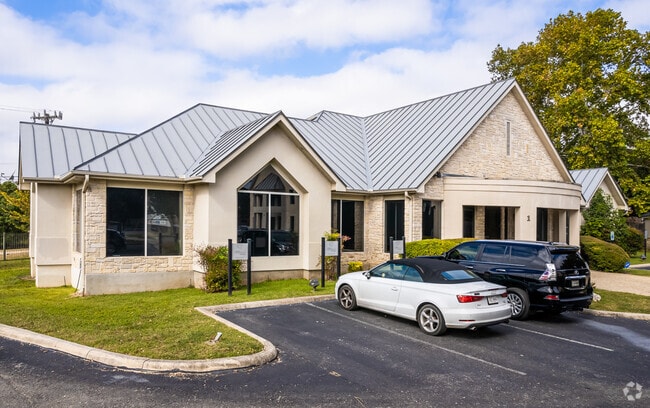
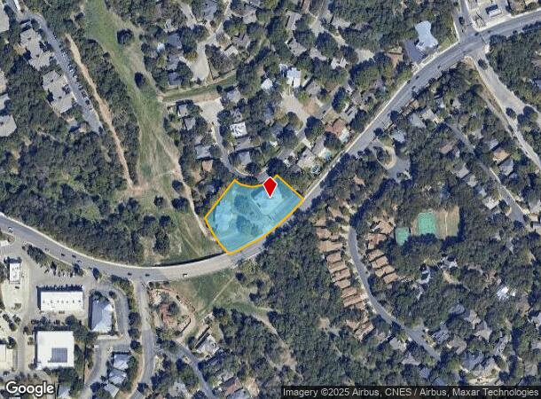
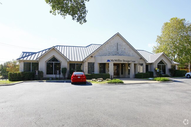
Property Record
1175 W Bitters Rd, San Antonio, TX 78216
NEARBY LISTINGS FOR SALE OR LEASE
Property Detail
1175 W Bitters Rd
San Antonio-New Braunfels, TX
Hidden Forest Sub Bl 17720 Un
17720-015-0660
NCB 17720 BLK 15 LOT 66 (HIDDEN FOREST UT-14)
Officebuilding
Bexar
X
Texas
48029C0235G
66
2024
1.49 AC
2025
North Central
191702
San Antonio
15,452 SF
DEMOGRAPHICS near 1175 W Bitters Rd
1 mile
3 mile
5 mile
2024 Total Population
10,343
91,481
231,607
2029 Population
10,896
97,180
246,276
Pop Growth 2024-2029
+ 5.35%
+ 6.23%
+ 6.33%
Average Age
40
40
39
2024 Total Households
4,721
40,258
99,874
HH Growth 2024-2029
+ 5.61%
+ 6.44%
+ 6.57%
Median Household Inc
$85,474
$76,539
$72,360
Avg Household Size
2.20
2.20
2.30
2024 Avg HH Vehicles
2.00
2.00
2.00
Median Home Value
$350,438
$353,151
$312,230
Median Year Built
1989
1988
1989
Nearby Places
Map Layers
Map Styles
 Street
 Aerial
Transit
 Traffic
 Biking
Places
Listings with unknown addresses are not visible on the map
- Restaurants
- Banks
- Shops
- Fitness
- Groceries
PUBLIC TRANSPORTATION
AIRPORT
San Antonio International
Drive
Walk
Distance
San Antonio International
9 min
5.6 mi
Freight Ports
Calhoun Port
Drive
Walk
Distance
Calhoun Port
192 min
160.3 mi
SALE & LEASE HISTORY
LISTING DATE
SALE/LEASE

Sep 27, 2021
For Lease
Oct 31, 2017
For Lease
Nearby Properties
Address
Land Use
TOTAL SIZE
Lot Size
Zoning
Address
Land Use
TOTAL SIZE
Lot Size
Zoning
338,255 SF
29.62 AC
Address
Land Use
TOTAL SIZE
Lot Size
Zoning
480,363 SF
28.52 AC
Address
Land Use
TOTAL SIZE
Lot Size
Zoning
292,126 SF
12.86 AC
Address
Land Use
TOTAL SIZE
Lot Size
Zoning
559,808 SF
24.43 AC
Address
Land Use
TOTAL SIZE
Lot Size
Zoning
308,375 SF
15.77 AC
Address
Land Use
TOTAL SIZE
Lot Size
Zoning
347,053 SF
12.94 AC
Address
Land Use
TOTAL SIZE
Lot Size
Zoning
295,141 SF
15.40 AC
Address
Land Use
TOTAL SIZE
Lot Size
Zoning
177,316 SF
19.83 AC
Address
Land Use
TOTAL SIZE
Lot Size
Zoning
641,471 SF
41.71 AC
Address
Land Use
TOTAL SIZE
Lot Size
Zoning
209,715 SF
22.91 AC
Address
Land Use
TOTAL SIZE
Lot Size
Zoning
327,760 SF
18.75 AC
Address
Land Use
TOTAL SIZE
Lot Size
Zoning
138,292 SF
17.91 AC
Address
Land Use
TOTAL SIZE
Lot Size
Zoning
289,271 SF
16.87 AC
Address
Land Use
TOTAL SIZE
Lot Size
Zoning
69,860 SF
20.10 AC
Address
Land Use
TOTAL SIZE
Lot Size
Zoning
234,914 SF
16.29 AC
Address
Land Use
TOTAL SIZE
Lot Size
Zoning
347,053 SF
12.94 AC
Address
Land Use
TOTAL SIZE
Lot Size
Zoning
223,288 SF
17.01 AC
Address
Land Use
TOTAL SIZE
Lot Size
Zoning
353,293 SF
18.74 AC
Address
Land Use
TOTAL SIZE
Lot Size
Zoning
152,676 SF
13.74 AC
Address
Land Use
TOTAL SIZE
Lot Size
Zoning
99,301 SF
13.49 AC
Address
Land Use
TOTAL SIZE
Lot Size
Zoning
33,045 SF
23.63 AC
Address
Land Use
TOTAL SIZE
Lot Size
Zoning
273,257 SF
17.62 AC
Address
Land Use
TOTAL SIZE
Lot Size
Zoning
240,711 SF
16.77 AC
Address
Land Use
TOTAL SIZE
Lot Size
Zoning
143,164 SF
30.79 AC
Address
Land Use
TOTAL SIZE
Lot Size
Zoning
190,879 SF
14.48 AC
Address
Land Use
TOTAL SIZE
Lot Size
Zoning
360,836 SF
16.87 AC
Address
Land Use
TOTAL SIZE
Lot Size
Zoning
402,327 SF
16.65 AC
Address
Land Use
TOTAL SIZE
Lot Size
Zoning
158,818 SF
4.33 AC
Address
Land Use
TOTAL SIZE
Lot Size
Zoning
291,920 SF
16.33 AC
Address
Land Use
TOTAL SIZE
Lot Size
Zoning
329,440 SF
14.89 AC
The World's #1 Commercial Real Estate Marketplace
Connect with us
© 2026 CoStar Group
The information above has been obtained from sources believed reliable. While we do not doubt its accuracy we have not verified it and make no guarantee, warranty or representation about it. It is your responsibility to independently confirm its accuracy and completeness. Any projections, opinions, assumptions, or estimates used are for example only and do not represent the current or future performance of the property. The value of this transaction to you depends on tax and other factors which should be evaluated by your tax, financial, and legal advisors. You and your advisors should conduct a careful, independent investigation of the property to determine to your satisfaction the suitability of the property for your needs.