Property Record
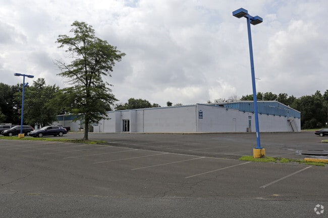
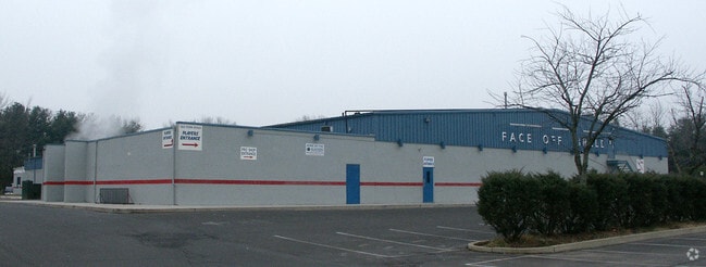
1185 York Rd, Warminster, PA 18974

Property Detail
1185 York Rd
49-009-086
5.6455 AC ES SR263 1454 N OF T334
Skatingrink
Bucks
C
Pennsylvania
B and X Area of moderate flood hazard, usually the area between the limits of the 100-year and 500-year floods.
5.65 AC
2024
Lower Bucks County
2025
Philadelphia
101609
Philadelphia-Camden-Wilmington, PA-NJ-DE-MD
58,107 SF
NEARBY LISTINGS FOR SALE OR LEASE
DEMOGRAPHICS near 1185 York Rd
1 mile
3 mile
5 mile
2025 Total Population
10,179
68,770
152,123
2030 Population
10,232
69,555
154,138
Pop Growth 2025-2030
+ 0.52%
+ 1.14%
+ 1.32%
Average Age
45
44
44
2025 Total Households
3,962
26,514
57,902
HH Growth 2025-2030
+ 0.53%
+ 1.16%
+ 1.42%
Median Household Inc
$102,088
$108,007
$111,430
Avg Household Size
2.50
2.50
2.50
2025 Avg HH Vehicles
2.00
2.00
2.00
Median Home Value
$422,914
$455,212
$472,359
Median Year Built
1976
1977
1976
Nearby Places
Map Layers
Map Styles
 Street
 Aerial
Transit
 Traffic
 Biking
Places
Listings with unknown addresses are not visible on the map
- Restaurants
- Banks
- Shops
- Fitness
- Groceries
PUBLIC TRANSPORTATION
COMMUTER RAIL
Warminster (R2 - Southeastern Pennsylvania Transportation Authority Regional Rail (SEPTA Regional Rail))
Drive
Walk
Distance
Warminster (R2 - Southeastern Pennsylvania Transportation Authority Regional Rail (SEPTA Regional Rail))
5 min
2.7 mi
Hatboro (R2 - Southeastern Pennsylvania Transportation Authority Regional Rail (SEPTA Regional Rail))
Drive
Walk
Distance
Hatboro (R2 - Southeastern Pennsylvania Transportation Authority Regional Rail (SEPTA Regional Rail))
8 min
4.0 mi
AIRPORT
Trenton Mercer
Drive
Walk
Distance
Trenton Mercer
35 min
20.2 mi
Philadelphia International
Drive
Walk
Distance
Philadelphia International
59 min
34.8 mi
Freight Ports
Port of Philadelphia
Drive
Walk
Distance
Port of Philadelphia
37 min
20.5 mi
Nearby Properties
Address
Land Use
TOTAL SIZE
Lot Size
Zoning
Address
Land Use
TOTAL SIZE
Lot Size
Zoning
110,198 SF
12.18 AC
R2
Address
Land Use
TOTAL SIZE
Lot Size
Zoning
94,059 SF
19.22 AC
R4
Address
Land Use
TOTAL SIZE
Lot Size
Zoning
240,682 SF
4.81 AC
HI
Address
Land Use
TOTAL SIZE
Lot Size
Zoning
162,363 SF
2.72 AC
HI
Address
Land Use
TOTAL SIZE
Lot Size
Zoning
257,048 SF
36.13 AC
C
Address
Land Use
TOTAL SIZE
Lot Size
Zoning
34,588 SF
4 AC
C2
Address
Land Use
TOTAL SIZE
Lot Size
Zoning
58,318 SF
20.12 AC
R4
Address
Land Use
TOTAL SIZE
Lot Size
Zoning
322,194 SF
37.79 AC
Address
Land Use
TOTAL SIZE
Lot Size
Zoning
4,687 SF
4.15 AC
GC2
Address
Land Use
TOTAL SIZE
Lot Size
Zoning
29,308 SF
15.96 AC
I
Address
Land Use
TOTAL SIZE
Lot Size
Zoning
89,732 SF
12.31 AC
I1
Address
Land Use
TOTAL SIZE
Lot Size
Zoning
72,852 SF
21.24 AC
R2
Address
Land Use
TOTAL SIZE
Lot Size
Zoning
59,133 SF
6.67 AC
LC3
Address
Land Use
TOTAL SIZE
Lot Size
Zoning
116,399 SF
6.48 AC
GC2
Address
Land Use
TOTAL SIZE
Lot Size
Zoning
56,668 SF
3.68 AC
R4
Address
Land Use
TOTAL SIZE
Lot Size
Zoning
89,344 SF
9.69 AC
R2
Address
Land Use
TOTAL SIZE
Lot Size
Zoning
25,021 SF
10.82 AC
I
Address
Land Use
TOTAL SIZE
Lot Size
Zoning
249,396 SF
18.70 AC
I
Address
Land Use
TOTAL SIZE
Lot Size
Zoning
125,391 SF
14.03 AC
OBD
Address
Land Use
TOTAL SIZE
Lot Size
Zoning
54,890 SF
9.37 AC
I2
Address
Land Use
TOTAL SIZE
Lot Size
Zoning
170,644 SF
26.62 AC
CBD
Address
Land Use
TOTAL SIZE
Lot Size
Zoning
3,600 SF
16 AC
GC2
Address
Land Use
TOTAL SIZE
Lot Size
Zoning
15,568 SF
7.86 AC
GC2
Address
Land Use
TOTAL SIZE
Lot Size
Zoning
97,622 SF
12.86 AC
CBD
Address
Land Use
TOTAL SIZE
Lot Size
Zoning
29,485 SF
2.40 AC
GC2
Address
Land Use
TOTAL SIZE
Lot Size
Zoning
34,720 SF
3.09 AC
GC2
Address
Land Use
TOTAL SIZE
Lot Size
Zoning
140,444 SF
15.31 AC
I
Address
Land Use
TOTAL SIZE
Lot Size
Zoning
73,663 SF
14.84 AC
MF-1
Address
Land Use
TOTAL SIZE
Lot Size
Zoning
43,392 SF
2.90 AC
R4
Address
Land Use
TOTAL SIZE
Lot Size
Zoning
25,347 SF
1.32 AC
R2
The World's #1 Commercial Real Estate Marketplace
Connect with us
© 2026 CoStar Group
The information above has been obtained from sources believed reliable. While we do not doubt its accuracy we have not verified it and make no guarantee, warranty or representation about it. It is your responsibility to independently confirm its accuracy and completeness. Any projections, opinions, assumptions, or estimates used are for example only and do not represent the current or future performance of the property. The value of this transaction to you depends on tax and other factors which should be evaluated by your tax, financial, and legal advisors. You and your advisors should conduct a careful, independent investigation of the property to determine to your satisfaction the suitability of the property for your needs.