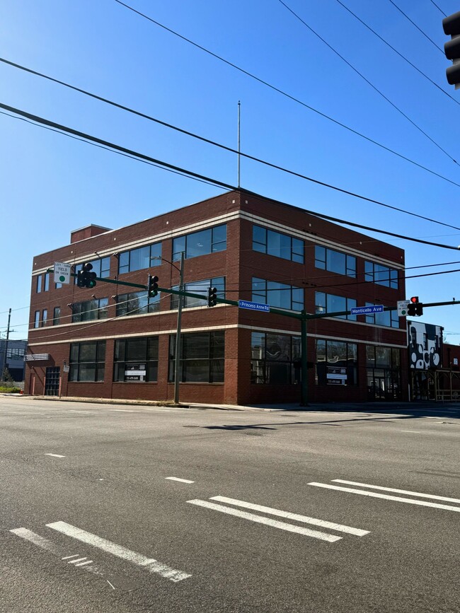
Property Record
119 E Princess Anne Rd, Norfolk, VA 23510


Save to a Folder
{{folder.Name}}
{{folder.ListingIds.length}} Properties
{{folder.ListingIds.length}} Property
Create a New Folder
Current Lease Availabilities
Property Detail
119 E Princess Anne Rd
41350050
10-11-12 BLK 2
Storebuilding
Norfolk City
G1
Virginia
AE The base floodplain where base flood elevations are provided. AE Zones are now used on new format FIRMs instead of A1-A30 Zones.
0.20 AC
2025
Downtown Norfolk
2025
Hampton Roads
004001
Virginia Beach-Chesapeake-Norfolk, VA-NC
22,500 SF
NEARBY LISTINGS FOR SALE OR LEASE
DEMOGRAPHICS near 119 E Princess Anne Rd
1 mile
3 mile
5 mile
2025 Total Population
22,965
111,019
253,555
2030 Population
22,706
109,938
251,011
Pop Growth 2025-2030
(1.13%)
(0.97%)
(1.00%)
Average Age
37
37
37
2025 Total Households
11,676
45,654
101,831
HH Growth 2025-2030
(1.27%)
(1.15%)
(1.16%)
Median Household Inc
$64,339
$60,033
$61,165
Avg Household Size
1.90
2.20
2.30
2025 Avg HH Vehicles
1.00
1.00
2.00
Median Home Value
$440,997
$308,682
$280,093
Median Year Built
1971
1962
1964
Nearby Places
Map Layers
Map Styles
 Street
 Aerial
Layers
 Traffic
 Biking
Places
Listings with unknown addresses are not visible on the map
- Restaurants
- Banks
- Shops
- Fitness
- Groceries
PUBLIC TRANSPORTATION
TRANSIT/SUBWAY
Monticello (Tide Light Rail - Hampton Roads Transit (HRT))
Drive
Walk
Distance
Monticello (Tide Light Rail - Hampton Roads Transit (HRT))
2 min
13 min
0.7 mi
York Street / Freemason (Tide Light Rail - Hampton Roads Transit (HRT))
Drive
Walk
Distance
York Street / Freemason (Tide Light Rail - Hampton Roads Transit (HRT))
3 min
15 min
0.8 mi
MacArthur Square (Tide Light Rail - Hampton Roads Transit (HRT))
Drive
Walk
Distance
MacArthur Square (Tide Light Rail - Hampton Roads Transit (HRT))
3 min
19 min
1.0 mi
COMMUTER RAIL
Drive
Walk
Distance
4 min
1.8 mi
AIRPORT
Norfolk International
Drive
Walk
Distance
Norfolk International
13 min
6.3 mi
Newport News/Williamsburg International
Drive
Walk
Distance
Newport News/Williamsburg International
44 min
27.7 mi
Freight Ports
Virginia Port Authority - Portsmouth
Drive
Walk
Distance
Virginia Port Authority - Portsmouth
12 min
4.0 mi
Nearby Properties
Address
Land Use
TOTAL SIZE
Lot Size
Zoning
Address
Land Use
TOTAL SIZE
Lot Size
Zoning
331,760 SF
24.97 AC
Address
Land Use
TOTAL SIZE
Lot Size
Zoning
5,704 SF
4.67 AC
D2
Address
Land Use
TOTAL SIZE
Lot Size
Zoning
85,756 SF
3.59 AC
D5
Address
Land Use
TOTAL SIZE
Lot Size
Zoning
421,540 SF
2.37 AC
Address
Land Use
TOTAL SIZE
Lot Size
Zoning
192,422 SF
10.70 AC
D4
Address
Land Use
TOTAL SIZE
Lot Size
Zoning
250,766 SF
31.14 AC
NMU
Address
Land Use
TOTAL SIZE
Lot Size
Zoning
390,960 SF
4.43 AC
Address
Land Use
TOTAL SIZE
Lot Size
Zoning
390,960 SF
4.43 AC
Address
Land Use
TOTAL SIZE
Lot Size
Zoning
73,136 SF
5.34 AC
IN2
Address
Land Use
TOTAL SIZE
Lot Size
Zoning
55.11 AC
IN2
Address
Land Use
TOTAL SIZE
Lot Size
Zoning
92.17 AC
OSP
Address
Land Use
TOTAL SIZE
Lot Size
Zoning
421,856 SF
2.64 AC
D1
Address
Land Use
TOTAL SIZE
Lot Size
Zoning
971,654 SF
6.01 AC
D2
Address
Land Use
TOTAL SIZE
Lot Size
Zoning
310,912 SF
3.94 AC
Address
Land Use
TOTAL SIZE
Lot Size
Zoning
689,954 SF
63.25 AC
Address
Land Use
TOTAL SIZE
Lot Size
Zoning
473,072 SF
9.72 AC
SD
Address
Land Use
TOTAL SIZE
Lot Size
Zoning
68,643 SF
24.68 AC
Address
Land Use
TOTAL SIZE
Lot Size
Zoning
192,270 SF
1.99 AC
D2
Address
Land Use
TOTAL SIZE
Lot Size
Zoning
126,088 SF
4.91 AC
C2
Address
Land Use
TOTAL SIZE
Lot Size
Zoning
363,974 SF
1.49 AC
Address
Land Use
TOTAL SIZE
Lot Size
Zoning
66,718 SF
4.09 AC
D5
Address
Land Use
TOTAL SIZE
Lot Size
Zoning
4.92 AC
IN1
Address
Land Use
TOTAL SIZE
Lot Size
Zoning
356,598 SF
1.84 AC
D2
Address
Land Use
TOTAL SIZE
Lot Size
Zoning
50,384 SF
0.74 AC
Address
Land Use
TOTAL SIZE
Lot Size
Zoning
291,748 SF
3.40 AC
G1
Address
Land Use
TOTAL SIZE
Lot Size
Zoning
91,982 SF
22.78 AC
IN1
Address
Land Use
TOTAL SIZE
Lot Size
Zoning
79,577 SF
3.04 AC
C2
Address
Land Use
TOTAL SIZE
Lot Size
Zoning
35,091 SF
0.71 AC
Address
Land Use
TOTAL SIZE
Lot Size
Zoning
197,074 SF
6.69 AC
Address
Land Use
TOTAL SIZE
Lot Size
Zoning
640,920 SF
3.67 AC
HCEF
The World's #1 Commercial Real Estate Marketplace
Connect with us
© 2026 CoStar Group
The information above has been obtained from sources believed reliable. While we do not doubt its accuracy we have not verified it and make no guarantee, warranty or representation about it. It is your responsibility to independently confirm its accuracy and completeness. Any projections, opinions, assumptions, or estimates used are for example only and do not represent the current or future performance of the property. The value of this transaction to you depends on tax and other factors which should be evaluated by your tax, financial, and legal advisors. You and your advisors should conduct a careful, independent investigation of the property to determine to your satisfaction the suitability of the property for your needs.