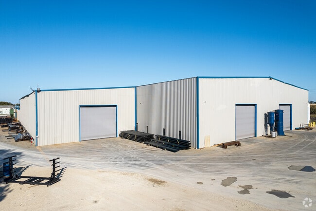
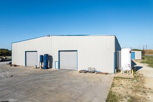
Property Record
11919 Interstate 35 N, Sanger, TX 76266

Save to a Folder
{{folder.Name}}
{{folder.ListingIds.length}} Properties
{{folder.ListingIds.length}} Property
Create a New Folder
Property Detail
11919 Interstate 35 N
R152061
A0002A J. AYERS, TR 20A, 4.453 ACRES, OLD DCAD TR 6,7(1A)
Commercialnec
Denton
B and X Area of moderate flood hazard, usually the area between the limits of the 100-year and 500-year floods.
Texas
2024
4.45 AC
2025
Outlying Denton County
020207
Dallas/Ft Worth
90,800 SF
Dallas-Fort Worth-Arlington, TX
NEARBY LISTINGS FOR SALE OR LEASE
-
-
View all Sanger listings for sale on LoopNet.com
DEMOGRAPHICS near 11919 Interstate 35 N
1 mile
3 mile
5 mile
2025 Total Population
195
6,027
31,578
2030 Population
221
6,842
35,988
Pop Growth 2025-2030
+ 13.33%
+ 13.52%
+ 13.97%
Average Age
39
38
38
2025 Total Households
72
2,181
11,226
HH Growth 2025-2030
+ 13.89%
+ 13.76%
+ 14.21%
Median Household Inc
$102,500
$98,064
$95,953
Avg Household Size
2.60
2.80
2.80
2025 Avg HH Vehicles
2.00
2.00
2.00
Median Home Value
$565,789
$336,916
$353,999
Median Year Built
2006
2001
2004
Nearby Places
Map Layers
Map Styles
 Street
 Aerial
Layers
 Traffic
 Biking
Places
Listings with unknown addresses are not visible on the map
- Restaurants
- Banks
- Shops
- Fitness
- Groceries
PUBLIC TRANSPORTATION
AIRPORT
Dallas-Fort Worth International
Drive
Walk
Distance
Dallas-Fort Worth International
45 min
36.8 mi
Nearby Properties
Address
Land Use
TOTAL SIZE
Lot Size
Zoning
Address
Land Use
TOTAL SIZE
Lot Size
Zoning
247,171 SF
20.30 AC
Address
Land Use
TOTAL SIZE
Lot Size
Zoning
1,094 SF
104.42 AC
Address
Land Use
TOTAL SIZE
Lot Size
Zoning
81,684 SF
13.35 AC
Address
Land Use
TOTAL SIZE
Lot Size
Zoning
75.95 AC
Address
Land Use
TOTAL SIZE
Lot Size
Zoning
102.50 AC
Address
Land Use
TOTAL SIZE
Lot Size
Zoning
66.67 AC
Address
Land Use
TOTAL SIZE
Lot Size
Zoning
1,153,213 SF
81.58 AC
Address
Land Use
TOTAL SIZE
Lot Size
Zoning
45.51 AC
Address
Land Use
TOTAL SIZE
Lot Size
Zoning
48,064 SF
4.34 AC
Address
Land Use
TOTAL SIZE
Lot Size
Zoning
48,977 SF
33.20 AC
Address
Land Use
TOTAL SIZE
Lot Size
Zoning
109,416 SF
10.77 AC
Address
Land Use
TOTAL SIZE
Lot Size
Zoning
71,906 SF
69.06 AC
Address
Land Use
TOTAL SIZE
Lot Size
Zoning
63.99 AC
Address
Land Use
TOTAL SIZE
Lot Size
Zoning
15,230 SF
40 AC
Address
Land Use
TOTAL SIZE
Lot Size
Zoning
1,217 SF
31.24 AC
Address
Land Use
TOTAL SIZE
Lot Size
Zoning
14,528 SF
9.39 AC
Address
Land Use
TOTAL SIZE
Lot Size
Zoning
2,475 SF
112.83 AC
Address
Land Use
TOTAL SIZE
Lot Size
Zoning
3,050 SF
42.34 AC
Address
Land Use
TOTAL SIZE
Lot Size
Zoning
118.85 AC
Address
Land Use
TOTAL SIZE
Lot Size
Zoning
8,011 SF
247.32 AC
Address
Land Use
TOTAL SIZE
Lot Size
Zoning
23.88 AC
Address
Land Use
TOTAL SIZE
Lot Size
Zoning
25,200 SF
14.35 AC
Address
Land Use
TOTAL SIZE
Lot Size
Zoning
85.17 AC
Address
Land Use
TOTAL SIZE
Lot Size
Zoning
2,949 SF
13.81 AC
Address
Land Use
TOTAL SIZE
Lot Size
Zoning
34,252 SF
2.79 AC
12A
Address
Land Use
TOTAL SIZE
Lot Size
Zoning
67,297 SF
9.32 AC
Address
Land Use
TOTAL SIZE
Lot Size
Zoning
8,769 SF
66.57 AC
Address
Land Use
TOTAL SIZE
Lot Size
Zoning
21,250 SF
3.45 AC
Address
Land Use
TOTAL SIZE
Lot Size
Zoning
500 SF
27.23 AC
The World's #1 Commercial Real Estate Marketplace
Connect with us
© 2026 CoStar Group
The information above has been obtained from sources believed reliable. While we do not doubt its accuracy we have not verified it and make no guarantee, warranty or representation about it. It is your responsibility to independently confirm its accuracy and completeness. Any projections, opinions, assumptions, or estimates used are for example only and do not represent the current or future performance of the property. The value of this transaction to you depends on tax and other factors which should be evaluated by your tax, financial, and legal advisors. You and your advisors should conduct a careful, independent investigation of the property to determine to your satisfaction the suitability of the property for your needs.