Property Record
I35, Sanger, TX 76266

Save to a Folder
{{folder.Name}}
{{folder.ListingIds.length}} Properties
{{folder.ListingIds.length}} Property
Create a New Folder
Property Detail
I35
Dallas-Fort Worth-Arlington, TX
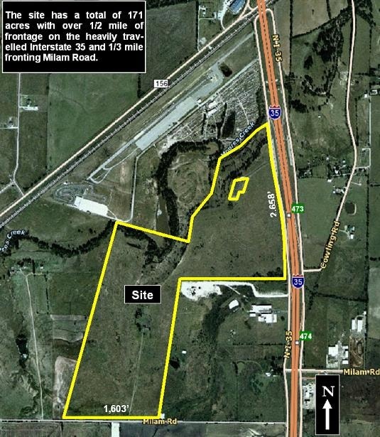
A0002A J. AYERS, TR 45, 63.991 ACRES, (SANGER ISD)
R57683
DENTON
Vacantlandnec
Texas
A Areas with a 1% annual chance of flooding and a 26% chance of flooding over the life of a 30-year mortgage.
63.99 AC
0
Denton
2025
Dallas/Ft Worth
020207
NEARBY LISTINGS FOR SALE OR LEASE
DEMOGRAPHICS near I35
1 mile
3 mile
5 mile
2025 Total Population
193
2,650
40,389
2030 Population
219
3,049
46,114
Pop Growth 2025-2030
+ 13.47%
+ 15.06%
+ 14.17%
Average Age
38
38
38
2025 Total Households
74
919
14,666
HH Growth 2025-2030
+ 14.86%
+ 15.13%
+ 14.39%
Median Household Inc
$94,642
$106,437
$91,889
Avg Household Size
2.60
2.80
2.70
2025 Avg HH Vehicles
2.00
2.00
2.00
Median Home Value
$499,999
$389,868
$334,614
Median Year Built
2010
2008
2001
Nearby Places
Map Layers
Map Styles
 Street
 Aerial
Layers
 Traffic
 Biking
Places
Listings with unknown addresses are not visible on the map
- Restaurants
- Banks
- Shops
- Fitness
- Groceries
PUBLIC TRANSPORTATION
COMMUTER RAIL
Downtown Denton Transit Center (A-train - Denton County Transportation Authority)
Drive
Walk
Distance
Downtown Denton Transit Center (A-train - Denton County Transportation Authority)
13 min
8.3 mi
AIRPORT
Dallas-Fort Worth International
Drive
Walk
Distance
Dallas-Fort Worth International
41 min
34.4 mi
Freight Ports
Tulsa Port of Inola
Drive
Walk
Distance
Tulsa Port of Inola
303 min
267.1 mi
Nearby Properties
Address
Land Use
TOTAL SIZE
Lot Size
Zoning
Address
Land Use
TOTAL SIZE
Lot Size
Zoning
374,520 SF
23.62 AC
Address
Land Use
TOTAL SIZE
Lot Size
Zoning
247,171 SF
20.30 AC
Address
Land Use
TOTAL SIZE
Lot Size
Zoning
66,330 SF
30 AC
Address
Land Use
TOTAL SIZE
Lot Size
Zoning
1,094 SF
104.42 AC
Address
Land Use
TOTAL SIZE
Lot Size
Zoning
81,684 SF
13.35 AC
Address
Land Use
TOTAL SIZE
Lot Size
Zoning
75.95 AC
Address
Land Use
TOTAL SIZE
Lot Size
Zoning
102.50 AC
Address
Land Use
TOTAL SIZE
Lot Size
Zoning
18,198 SF
16.98 AC
Address
Land Use
TOTAL SIZE
Lot Size
Zoning
66.67 AC
Address
Land Use
TOTAL SIZE
Lot Size
Zoning
1,153,213 SF
81.58 AC
Address
Land Use
TOTAL SIZE
Lot Size
Zoning
45.51 AC
Address
Land Use
TOTAL SIZE
Lot Size
Zoning
48,977 SF
33.20 AC
Address
Land Use
TOTAL SIZE
Lot Size
Zoning
71,906 SF
69.06 AC
Address
Land Use
TOTAL SIZE
Lot Size
Zoning
90,800 SF
4.45 AC
Address
Land Use
TOTAL SIZE
Lot Size
Zoning
15,230 SF
40 AC
Address
Land Use
TOTAL SIZE
Lot Size
Zoning
1,217 SF
31.24 AC
Address
Land Use
TOTAL SIZE
Lot Size
Zoning
14,528 SF
9.39 AC
Address
Land Use
TOTAL SIZE
Lot Size
Zoning
2,475 SF
112.83 AC
Address
Land Use
TOTAL SIZE
Lot Size
Zoning
3,050 SF
42.34 AC
Address
Land Use
TOTAL SIZE
Lot Size
Zoning
118.85 AC
Address
Land Use
TOTAL SIZE
Lot Size
Zoning
8,011 SF
247.32 AC
Address
Land Use
TOTAL SIZE
Lot Size
Zoning
23.88 AC
Address
Land Use
TOTAL SIZE
Lot Size
Zoning
25,200 SF
14.35 AC
Address
Land Use
TOTAL SIZE
Lot Size
Zoning
85.17 AC
Address
Land Use
TOTAL SIZE
Lot Size
Zoning
9,591 SF
9.52 AC
Address
Land Use
TOTAL SIZE
Lot Size
Zoning
2,949 SF
13.81 AC
Address
Land Use
TOTAL SIZE
Lot Size
Zoning
12,212 SF
7.56 AC
Address
Land Use
TOTAL SIZE
Lot Size
Zoning
8,769 SF
66.57 AC
Address
Land Use
TOTAL SIZE
Lot Size
Zoning
35.69 AC
The World's #1 Commercial Real Estate Marketplace
Connect with us
© 2026 CoStar Group
The information above has been obtained from sources believed reliable. While we do not doubt its accuracy we have not verified it and make no guarantee, warranty or representation about it. It is your responsibility to independently confirm its accuracy and completeness. Any projections, opinions, assumptions, or estimates used are for example only and do not represent the current or future performance of the property. The value of this transaction to you depends on tax and other factors which should be evaluated by your tax, financial, and legal advisors. You and your advisors should conduct a careful, independent investigation of the property to determine to your satisfaction the suitability of the property for your needs.