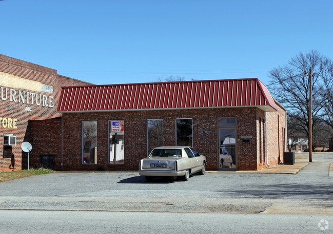
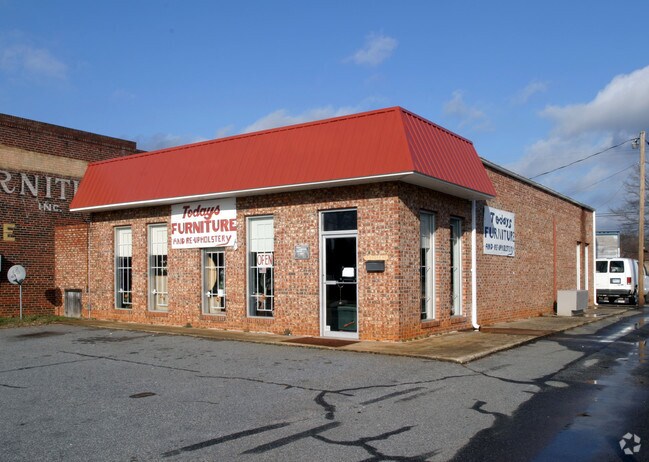
Property Record
12 Groce Rd, Lyman, SC 29365

Property Detail
12 Groce Rd
5-15-07-096.02
E SIDE GROCE RD S OF US HWY 29 PB 62-664
Commercialnec
Spartanburg
B and X Area of moderate flood hazard, usually the area between the limits of the 100-year and 500-year floods.
South Carolina
2024
0.25 AC
2025
Upper Spartanburg Cty
023104
Greenville/Spartanburg
6,950 SF
Spartanburg, SC
NEARBY LISTINGS FOR SALE OR LEASE
DEMOGRAPHICS near 12 Groce Rd
1 mile
3 mile
5 mile
2025 Total Population
3,825
22,662
53,125
2030 Population
4,289
25,288
59,280
Pop Growth 2025-2030
+ 12.13%
+ 11.59%
+ 11.59%
Average Age
38
38
38
2025 Total Households
1,481
8,487
19,572
HH Growth 2025-2030
+ 12.22%
+ 11.59%
+ 11.72%
Median Household Inc
$58,554
$63,268
$67,484
Avg Household Size
2.60
2.60
2.60
2025 Avg HH Vehicles
2.00
2.00
2.00
Median Home Value
$250,446
$245,387
$257,514
Median Year Built
1989
1995
1998
Nearby Places
Map Layers
Map Styles
 Street
 Aerial
Transit
 Traffic
 Biking
Places
Listings with unknown addresses are not visible on the map
- Restaurants
- Banks
- Shops
- Fitness
- Groceries
PUBLIC TRANSPORTATION
AIRPORT
Greenville Spartanburg International
Drive
Walk
Distance
Greenville Spartanburg International
13 min
8.1 mi
Nearby Properties
Address
Land Use
TOTAL SIZE
Lot Size
Zoning
Address
Land Use
TOTAL SIZE
Lot Size
Zoning
451,000 SF
47.03 AC
Address
Land Use
TOTAL SIZE
Lot Size
Zoning
185,745 SF
14.17 AC
Address
Land Use
TOTAL SIZE
Lot Size
Zoning
Address
Land Use
TOTAL SIZE
Lot Size
Zoning
2,528 SF
14.74 AC
Address
Land Use
TOTAL SIZE
Lot Size
Zoning
102.67 AC
Address
Land Use
TOTAL SIZE
Lot Size
Zoning
33.57 AC
Address
Land Use
TOTAL SIZE
Lot Size
Zoning
26,472 SF
3.90 AC
Address
Land Use
TOTAL SIZE
Lot Size
Zoning
1,964,569 SF
46.64 AC
Address
Land Use
TOTAL SIZE
Lot Size
Zoning
1,798 SF
9.63 AC
Address
Land Use
TOTAL SIZE
Lot Size
Zoning
28.26 AC
Address
Land Use
TOTAL SIZE
Lot Size
Zoning
67,938 SF
8.02 AC
Address
Land Use
TOTAL SIZE
Lot Size
Zoning
Address
Land Use
TOTAL SIZE
Lot Size
Zoning
3,105 SF
6.12 AC
Address
Land Use
TOTAL SIZE
Lot Size
Zoning
Address
Land Use
TOTAL SIZE
Lot Size
Zoning
31,301 SF
5 AC
Address
Land Use
TOTAL SIZE
Lot Size
Zoning
242,400 SF
10.30 AC
Address
Land Use
TOTAL SIZE
Lot Size
Zoning
Address
Land Use
TOTAL SIZE
Lot Size
Zoning
Address
Land Use
TOTAL SIZE
Lot Size
Zoning
3,166 SF
6.26 AC
Address
Land Use
TOTAL SIZE
Lot Size
Zoning
101,366 SF
13.63 AC
Address
Land Use
TOTAL SIZE
Lot Size
Zoning
3,373 SF
1.22 AC
Address
Land Use
TOTAL SIZE
Lot Size
Zoning
3,314 SF
0.58 AC
Address
Land Use
TOTAL SIZE
Lot Size
Zoning
4,325 SF
0.34 AC
Address
Land Use
TOTAL SIZE
Lot Size
Zoning
16,050 SF
26.33 AC
Address
Land Use
TOTAL SIZE
Lot Size
Zoning
10,684 SF
11.39 AC
Address
Land Use
TOTAL SIZE
Lot Size
Zoning
3,340 SF
0.19 AC
Address
Land Use
TOTAL SIZE
Lot Size
Zoning
3,066 SF
0.58 AC
Address
Land Use
TOTAL SIZE
Lot Size
Zoning
3,157 SF
0.34 AC
Address
Land Use
TOTAL SIZE
Lot Size
Zoning
71,373 SF
5.18 AC
Address
Land Use
TOTAL SIZE
Lot Size
Zoning
4,504 SF
0.43 AC
The World's #1 Commercial Real Estate Marketplace
Connect with us
© 2026 CoStar Group
The information above has been obtained from sources believed reliable. While we do not doubt its accuracy we have not verified it and make no guarantee, warranty or representation about it. It is your responsibility to independently confirm its accuracy and completeness. Any projections, opinions, assumptions, or estimates used are for example only and do not represent the current or future performance of the property. The value of this transaction to you depends on tax and other factors which should be evaluated by your tax, financial, and legal advisors. You and your advisors should conduct a careful, independent investigation of the property to determine to your satisfaction the suitability of the property for your needs.