Property Record
120 Chestnut St, North Easton, MA 02356
This Property Is For Sale
NEARBY LISTINGS FOR SALE OR LEASE
Property Detail
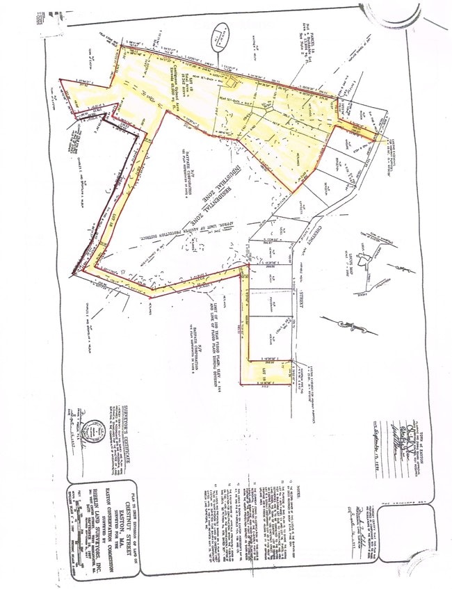
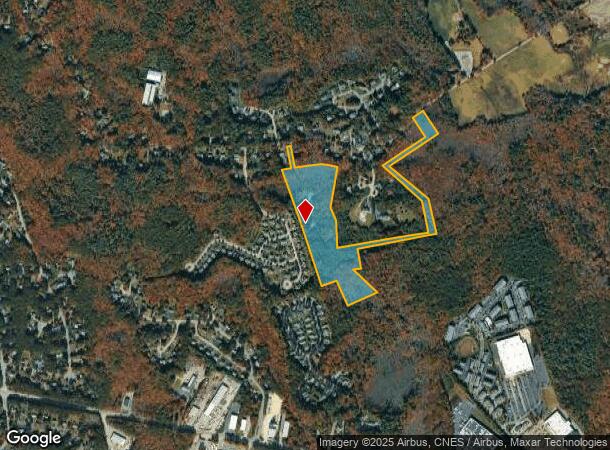
120 Chestnut St
Providence-Warwick, RI-MA
Bristol
EAST-000009R-000020
Massachusetts
Sfr
19.34 AC
AE
Attleboro/New Bedford
25021C0370E
Boston
2,176 SF
DEMOGRAPHICS near 120 Chestnut St
1 Mile
3 Mile
5 Mile
2024 Total Population
3,144
25,508
70,156
2029 Population
3,196
25,441
69,805
Pop Growth 2024-2029
+ 1.65%
(0.26%)
(0.50%)
Average Age
41
41
41
2024 Total Households
1,218
9,170
25,542
HH Growth 2024-2029
+ 1.72%
(0.28%)
(0.44%)
Median Household Inc
$118,142
$136,622
$116,702
Avg Household Size
2.60
2.70
2.60
2024 Avg HH Vehicles
2.00
2.00
2.00
Median Home Value
$643,186
$607,320
$548,634
Median Year Built
1994
1984
1979
Nearby Places
- Restaurants
- Banks
- Shops
- Fitness
- Groceries
PUBLIC TRANSPORTATION
COMMUTER RAIL
Mansfield (Foxboro Line (Special Events Only) - Massachusetts Bay Transportation Authority Commuter Rail (Purple Line), Providence/Stoughton Line - Massachusetts Bay Transportation Authority Commuter Rail (Purple Line))
DRIVE
WALK
Distance
Mansfield (Foxboro Line (Special Events Only) - Massachusetts Bay Transportation Authority Commuter Rail (Purple Line), Providence/Stoughton Line - Massachusetts Bay Transportation Authority Commuter Rail (Purple Line))
14 min
4.5 mi
Sharon (Providence/Stoughton Line - Massachusetts Bay Transportation Authority Commuter Rail (Purple Line))
DRIVE
WALK
Distance
Sharon (Providence/Stoughton Line - Massachusetts Bay Transportation Authority Commuter Rail (Purple Line))
21 min
7.7 mi
AIRPORT
General Edward Lawrence Logan International
DRIVE
WALK
Distance
General Edward Lawrence Logan International
54 min
33.5 mi
Rhode Island Tf Green International
DRIVE
WALK
Distance
Rhode Island Tf Green International
57 min
33.8 mi
Freight Ports
Port of Boston
DRIVE
WALK
Distance
Port of Boston
51 min
31.3 mi
Nearby Properties
Address
Land Use
TOTAL SIZE
Lot Size
Zoning
Address
Land Use
TOTAL SIZE
Lot Size
Zoning
20.33 AC
Address
Land Use
TOTAL SIZE
Lot Size
Zoning
Address
Land Use
TOTAL SIZE
Lot Size
Zoning
Address
Land Use
TOTAL SIZE
Lot Size
Zoning
22.56 AC
Address
Land Use
TOTAL SIZE
Lot Size
Zoning
270,179 SF
51 AC
Address
Land Use
TOTAL SIZE
Lot Size
Zoning
3,838 SF
1.11 AC
R80
Address
Land Use
TOTAL SIZE
Lot Size
Zoning
145,360 SF
11.80 AC
Address
Land Use
TOTAL SIZE
Lot Size
Zoning
Address
Land Use
TOTAL SIZE
Lot Size
Zoning
349,000 SF
61.70 AC
Address
Land Use
TOTAL SIZE
Lot Size
Zoning
105,664 SF
13.16 AC
Address
Land Use
TOTAL SIZE
Lot Size
Zoning
9.20 AC
Address
Land Use
TOTAL SIZE
Lot Size
Zoning
129,261 SF
12.87 AC
Address
Land Use
TOTAL SIZE
Lot Size
Zoning
103,765 SF
19.83 AC
Address
Land Use
TOTAL SIZE
Lot Size
Zoning
4.50 AC
Address
Land Use
TOTAL SIZE
Lot Size
Zoning
59.40 AC
Address
Land Use
TOTAL SIZE
Lot Size
Zoning
21.17 AC
Address
Land Use
TOTAL SIZE
Lot Size
Zoning
79,958 SF
2.90 AC
Address
Land Use
TOTAL SIZE
Lot Size
Zoning
15.28 AC
Address
Land Use
TOTAL SIZE
Lot Size
Zoning
601.06 AC
Address
Land Use
TOTAL SIZE
Lot Size
Zoning
2.50 AC
Address
Land Use
TOTAL SIZE
Lot Size
Zoning
773.37 AC
Address
Land Use
TOTAL SIZE
Lot Size
Zoning
4.60 AC
Address
Land Use
TOTAL SIZE
Lot Size
Zoning
4.90 AC
Address
Land Use
TOTAL SIZE
Lot Size
Zoning
39,527 SF
5.20 AC
Address
Land Use
TOTAL SIZE
Lot Size
Zoning
Address
Land Use
TOTAL SIZE
Lot Size
Zoning
6.09 AC
Address
Land Use
TOTAL SIZE
Lot Size
Zoning
199,572 SF
10.80 AC
Address
Land Use
TOTAL SIZE
Lot Size
Zoning
41,257 SF
13 AC
Address
Land Use
TOTAL SIZE
Lot Size
Zoning
46,246 SF
12.08 AC
Address
Land Use
TOTAL SIZE
Lot Size
Zoning
76.50 AC
R80
The World's #1 Commercial Real Estate Marketplace
Connect with us
© 2025 CoStar Group
The information above has been obtained from sources believed reliable. While we do not doubt its accuracy we have not verified it and make no guarantee, warranty or representation about it. It is your responsibility to independently confirm its accuracy and completeness. Any projections, opinions, assumptions, or estimates used are for example only and do not represent the current or future performance of the property. The value of this transaction to you depends on tax and other factors which should be evaluated by your tax, financial, and legal advisors. You and your advisors should conduct a careful, independent investigation of the property to determine to your satisfaction the suitability of the property for your needs.